
| PHILLIPS ARMY AIRFIELD (PVT) ABERDEEN PROVING GND MD |
| |
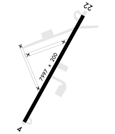
| Lat: N 3927.9 Long: W 07610.1 Elev: 45 Var: +10 Longest Runway: 7998 | ||
| Dept. ATIS: 124.42 Arr. ATIS: 124.42 Ground: 121.9 Tower: 126.15 | ||
| |||||
|
| Rwy | Rwy | |||||||
| 7998x200 | 7998' | 7998x200 | 7998' | |||||
| Runway ID | Single Wheel | Double Wheel | Double Tandem Wheel | Dual Double Wheel |
| 04/22 | N/A | N/A | N/A | N/A |
| These numbers are Advisory and are not limits. The Airport Manager should have more accurate Weight Limits | ||||
 Airport Diagram might not be current. | |
| Facility Name: | PHILLIPS AAF |
| City Name: | ABERDEEN PROVING GROUNDS(ABERDEEN) |
| County: | HARFORD |
| State abbrev: | MD |
| State Name: | MARYLAND |
| Ownership: | ARMY OWNED |
| Use: | PRIVATE |
| Owner's Name: | US ARMY ATCA-ASO |
| Address: | CAMERON STA |
| ALEXANDRIA, VA 22314 | |
| Owner's Phone: | |
| Manager's Name: | WARREN HADAWAY |
| Address: | |
| Phone: | 410-278-4902 |
| FAA Region: | EASTERN |
| FAA Field Office: | DCA |
| Date | Sunrise | Sunset |
|---|---|---|
| 09/24/21 Friday | 6:54 | 18:59 |
| 09/25/21 Saturday | 6:55 | 18:57 |
| 09/26/21 Sunday | 6:56 | 18:56 |
| 09/27/21 Monday | 6:57 | 18:54 |
| 09/28/21 Tuesday | 6:58 | 18:52 |
| 09/29/21 Wednesday | 6:59 | 18:51 |
| 09/30/21 Thursday | 7:00 | 18:49 |
| 10/01/21 Friday | 7:01 | 18:48 |
| 10/02/21 Saturday | 7:01 | 18:46 |
| 10/03/21 Sunday | 7:02 | 18:44 |
| 10/04/21 Monday | 7:03 | 18:43 |
| 10/05/21 Tuesday | 7:04 | 18:41 |
| 10/06/21 Wednesday | 7:05 | 18:40 |
| 10/07/21 Thursday | 7:06 | 18:38 |
| Airport Attendance Schedule | MON-FRI 1100-0200Z++, EXCP HOL |
| Airport Status | OPERATIONAL (This Status can change at any time - please check NOTAMS) |
| Airport Lighting Schedule | ACTVT REIL RWY 22; PAPI RWY 22; HIRL RWY 04/22, WHEN TWR CLSD BY PPR ONLY. |
| Airport Storage Available | NONE |
| Extra Services Available | NONE |
| Wind Indicator | NONE |
| Control Tower | YES |
| CTAF Frequency | |
| Unicom Frequency | |
| Rotating Beacon Color | SPLIT-CLEAR-GREEN (LIGHTED MILITARY AIRPORT) |
| Segmented Circle | NO |
| Landing Fee |
| Airport Inspected | No Inspection Data Available performed by the OWNER |
| Inspection Date | Unknown |
| Type of Fuel Available | None |
| Airframe Repair Service | None |
| Power Plant Repair Service | None |
| Latitude | N3927.9 |
| Longitude | W07610.1 (ESTIMATED) |
| Arpt Elevation | 44ft (SURVEYED) |
| Magnetic Variation | 10W |
| 2 miles S | of ABERDEEN PROVING GROUNDS(ABERDEEN) |
| Traffic Pattern Altitude | |
| Sectional Chart | WASHINGTON |
| Operations (Reported) | Yearly | Avg. Daily |
|---|---|---|
| General Aviation Transient | 0 | 0 |
| General Aviation Local | 0 | 0 |
| Air Taxi | 0 | 0 |
| Commerical | 0 | 0 |
| Commuter | 0 | 0 |
| Military | 0 | 0 |
| Aircraft based on Field | |
|---|---|
| General Aviation Singles | 0 |
| General Aviation Multi | 0 |
| Jet Aircraft | 0 |
| General Aviation Helicopters | 0 |
| Military Aircraft | 0 |
| Gliders | 0 |
| Ultralights | 0 |
| FSS on field | NO |
| FSS tie-in | LEESBURG |
| FSS Phone | 1-800-WX-BRIEF |
| Who issues Notams | DCA |
| Notam D service at airport | YES |
| ARTCC Name | WASHINGTON |
| Airport Certification | ACFT RESCUE AND FIRE FIGHTING PROTECTION NOT LCTD ON AFLD. |
| Aircraft Rescue & Firefighting Index | MISC: ARFF PROTECTION NOT LCTD ON AFLD. ARFF STN MAY NOT BE STAFFED DURG AFLD NON-OPR HRS. |
| Airport of Entry | No |
| Custom Landing Rights | No |
| Joint Civil/Military | No |
| Military Landing rights | No |
| MISC- AFLD SIGNS NSTD OR MISSING. AFLD MARKINGS FADED OR MISSING. |
| FOR CD WHEN ATCT IS CLSD CTC POTOMAC APCH AT 866-429-5882. |
| FUEL: J8. |
| OIL: 0-113-556(MIL). |
| REMARKS: AFLD OPR 1100-2300Z++ MON-FRI EXC HOL. TWR OPR 1300-2100Z++MON-FRI EXC HOL. |
| RSTD: 24 HR PPR ALL ACFT. TRAN ACFT LDG AT ANY SITE OTHER THAN ARPT BEFORE SR OR 1200Z++, WHICHEVER IS LATER OR AFTER SS IS PROH. DSN 298-3483/3074, C410-278-3483/3074. RWY 08/26 LTD TO 25,000 LB GWT. TOUCH AND GO LDG PROH WHILE VEH TEST IN PROGRESS, LO APCH ONLY. |
| CAUTION: IMPACT AREA 1300 YD 'S' OF RY 04/22 AND 2.5 MILES 'SW' OF DEP ENF OF RY 22. DEER HAZ. CTC TWR 15 MIN PRIOR TO ARR TO ARNG DEER SWEEP. IF TWR CLSD USE EXTREME CAUTION. |
| NS ABTMT: NOISE SENSITIVE AREA. USE NS ABTMT OPR PRO. |
| MISC: CLASS D AIRSPACE EFF 1230-2130Z++ MON-FRI, AND HOL WHEN TWR OPEN, OT CLASS E. |
| MISC: ARFF PROTECTION NOT LCTD ON AFLD. ARFF STN MAY NOT BE STAFFED DURG AFLD NON-OPR HRS. |
Airport Communications & Frequencies:
| ||||||||||||||||||||||||
| Runway: 04 | Runway: 22 | ||
| Mag heading: | N/A | Mag heading: | N/A |
| Rwy Slope: | .21% Up | Rwy Slope: | -.21% Down |
| Approach: | Approach: | ||
| Pattern: | Left Traffic | Pattern: | Left Traffic |
| Markings: | PRECISION INSTRUMENT | Markings: | PRECISION INSTRUMENT |
| Marking Condition: | GOOD | Marking Condition: | GOOD |
| Arresting Dev: | Arresting Dev: | ||
| Lat & Long: | N3927.3 W07610.5 | Lat. & Long.: | N3928.5 W07609.7 |
| Elev: | 27.6 ft. MSL | Elev: | 44.5 ft. MSL |
| TCH: | TCH: | 49 ft. AGL | |
| Visual Glide Path: | Visual Glide Path: | 3.00 degrees | |
| Displaced Threshold: | No | Displaced Threshold: | No |
| Touchdown Zone: | YES | Touchdown Zone: | YES |
| Touchdown Elev.: | 34.3 feet | Touchdown Elev.: | 44.5 feet |
| Visual Glide Slope: | Visual Glide Slope: | 4-Light PAPI on LEFT side of Runway | |
| RVR Equipment: | RVR Equipment: | ||
| RVV Equipment: | NO | RVV Equipment: | NO |
| Approach Lights: | Approach Lights: | ||
| REIL: | NO | REIL: | YES |
| Centerline Lights: | NO | Centerline Lights: | NO |
| Touchdown lights: | NO | Touchdown lights: | NO |
| Runway Category: | Runway Category: | ||
| Declared Distances: | Declared Distances: |
Thanks for using FltPlan.com
all rights reserved © 1999-2021 by Flight Plan LLC
