
| NAPA COUNTY NAPA CA |
| |
| Lat: N 3812.8 Long: W 12216.8 Elev: 36 Var: -15 Longest Runway: 5930 | ||
| Clr Del: 127.85 Dept. ATIS: 124.05 Arr. ATIS: 124.05 AWOS: 124.05 Ground: 121.7 Tower: 118.7 | ||
| ||||||||||||||||||||||||||||||||||||||||||||||||||||||||||||||
| ||||||||||||||||||||||||||||||||||||||||||||||||||||||||||||||
| ||||||||||||||||||||||||||||||||||||||||||||||||||||||||||||||
| ||||||||||||||||||||||||||||||||||||||||||||||||||||||||||||||
| FBOs at nearby airports who want your business: | |||||||||||||||||
| |||||||||||||||||
| Rwy | Rwy | |||||||
| 5930x150 | 5930' | 111.30 - 005° | 5930x150 | 5930' | ||||
| 2510x75 | 2510' | 2510x75 | 2510' | |||||
| 5008x150 | 5008' | 5008x150 | 5008' | |||||
| Runway ID | Single Wheel | Double Wheel | Double Tandem Wheel | Dual Double Wheel |
| 01L/19R | 102,000 | 134,000 | 120,000 | N/A |
| 01R/19L | 13,500 | N/A | N/A | N/A |
| 06/24 | 60,000 | 76,000 | 120,000 | N/A |
| These numbers are Advisory and are not limits. The Airport Manager should have more accurate Weight Limits | ||||
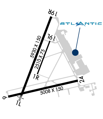 Airport Diagram might not be current. | |
| Facility Name: | NAPA COUNTY |
| City Name: | NAPA |
| County: | NAPA |
| State abbrev: | CA |
| State Name: | CALIFORNIA |
| Ownership: | PUBLICLY OWNED |
| Use: | OPEN TO THE PUBLIC |
| Owner's Name: | NAPA COUNTY |
| Address: | 2000 AIRPORT RD. |
| NAPA, CA 94558 | |
| Owner's Phone: | 707-253-4300 |
| Manager's Name: | MARK WITSOE |
| Address: | 2000 AIRPORT RD. |
| NAPA, CA 94558 | |
| Phone: | 707-253-4300 |
| FAA Region: | WESTERN-PACIFIC |
| FAA Field Office: | SFO |
| Date | Sunrise | Sunset |
|---|---|---|
| 06/08/26 Monday | 5:46 | 20:31 |
| 06/09/26 Tuesday | 5:46 | 20:31 |
| 06/10/26 Wednesday | 5:45 | 20:32 |
| 06/11/26 Thursday | 5:45 | 20:32 |
| 06/12/26 Friday | 5:45 | 20:33 |
| 06/13/26 Saturday | 5:45 | 20:33 |
| 06/14/26 Sunday | 5:45 | 20:34 |
| 06/15/26 Monday | 5:45 | 20:34 |
| 06/16/26 Tuesday | 5:45 | 20:34 |
| 06/17/26 Wednesday | 5:45 | 20:35 |
| 06/18/26 Thursday | 5:46 | 20:35 |
| 06/19/26 Friday | 5:46 | 20:35 |
| 06/20/26 Saturday | 5:46 | 20:35 |
| 06/21/26 Sunday | 5:46 | 20:36 |
| Airport Attendance Schedule | 7 Days A Week 0700-2000 |
| Airport Status | OPERATIONAL (This Status can change at any time - please check NOTAMS) |
| Airport Lighting Schedule | WHEN ATCT CLSD ACTVT MALS RWY 01L; REIL RWY 06; MIRL RWYS 01L/19R & RWY 06/24 - CTAF. PAPI RWY 19R OPR CONSLY. |
| Airport Storage Available | Tie Downs |
| Extra Services Available | Charter, Flight Instruction, Aircraft Rental, Aircraft Sales |
| Wind Indicator | YES - (lighted) |
| Control Tower | YES |
| CTAF Frequency | 118.700 |
| Unicom Frequency | 122.950 |
| Rotating Beacon Color | WG |
| Segmented Circle | YES |
| Landing Fee | YES; LDG FEE CHRGD TO ALL AIR TAXI, COML ACFT OPNS (EXCLDG FLT INSTRUCTION), AND TSNT ACFT WEIGHING MORE THAN 12500 LBS. |
| Airport Inspected | STATE - performed by STATE AERONAUTICAL PERSONNEL |
| Inspection Date | 09/05/2025 |
| Type of Fuel Available | Grade 100LL, JET A (freeze point -40C); -10FOR FUEL SVC 2100-0600 CALL 707-224-0887. |
| Airframe Repair Service | MAJOR |
| Power Plant Repair Service | MAJOR |
| Latitude | N3812.8 |
| Longitude | W12216.8 (ESTIMATED) |
| Arpt Elevation | 35ft (SURVEYED) |
| Magnetic Variation | 15E |
| 5 miles S | of NAPA |
| Traffic Pattern Altitude | |
| Sectional Chart | SAN FRANCISCO |
| Operations (Reported) | Yearly | Avg. Daily |
|---|---|---|
| General Aviation Transient | 0 | 0 |
| General Aviation Local | 0 | 0 |
| Air Taxi | 0 | 0 |
| Commerical | 0 | 0 |
| Commuter | 0 | 0 |
| Military | 0 | 0 |
| Aircraft based on Field | |
|---|---|
| General Aviation Singles | 0 |
| General Aviation Multi | 0 |
| Jet Aircraft | 0 |
| General Aviation Helicopters | 0 |
| Military Aircraft | 0 |
| Gliders | 0 |
| Ultralights | 0 |
| FSS on field | NO |
| FSS tie-in | OAKLAND |
| FSS Phone | 1-800-WX-BRIEF |
| Who issues Notams | APC |
| Notam D service at airport | YES |
| ARTCC Name | OAKLAND |
| Airport Certification | |
| Aircraft Rescue & Firefighting Index | None |
| Airport of Entry | No |
| Custom Landing Rights | No |
| Joint Civil/Military | No |
| Military Landing rights | YES |
| NATIONAL PLAN OF INTEGRATED AIRPORT SYSTEMS (NPIAS) |
| GRANT AGREEMENTS UNDER FAAP/ADAP/AIP |
| ASSURANCES PURSUANT TO TITLE VI, CIVIL RIGHTS ACT OF 1964 |
| ASPH TWYS STRENGTH 30,000 GWT SINGLE WHEEL. |
| ASPH APRONS STRENGTH 12500-30000 LBS GWT SINGLE WHEEL. |
| UNLGTD BRIDGE 1 NM S, 167 FT AGL |
| DUE TO AIRPORT PROXIMITY TO WETLANDS BIRDS ON AND INVOF THE AIRPORT YEAR AROUND WITH HIGHEST CONCENTRATION OF ACTIVITY OF BIRDS ON THE RYS DURING RAINY WEATHER. |
| FOR CD WHEN ATCT CLSD CTC OAKLAND ARTCC AT 510-745-3380. |
Airport Communications & Frequencies:
| |||||||||||||||||||||
| Runway: 01L | Runway: 19R | ||
| Mag heading: | 6° | Mag heading: | 186° |
| Rwy Slope: | .26% Up | Rwy Slope: | -.26% Down |
| Approach: | ILS/DME | Approach: | |
| Pattern: | Left Traffic | Pattern: | Right Traffic |
| Markings: | PRECISION INSTRUMENT | Markings: | NONPRECISION INSTRUMENT |
| Marking Condition: | GOOD | Marking Condition: | GOOD |
| Arresting Dev: | Arresting Dev: | ||
| Lat & Long: | N3812.5 W12217.1 | Lat. & Long.: | N3813.4 W12216.7 |
| Elev: | 14.5 ft. MSL | Elev: | 29.7 ft. MSL |
| TCH: | TCH: | 52 ft. AGL | |
| Visual Glide Path: | Visual Glide Path: | 3.25 degrees | |
| Displaced Threshold: | No | Displaced Threshold: | No |
| Touchdown Zone: | YES | Touchdown Zone: | YES |
| Touchdown Elev.: | 17.1 feet | Touchdown Elev.: | 29.7 feet |
| Visual Glide Slope: | Visual Glide Slope: | 4-Light PAPI on LEFT side of Runway | |
| RVR Equipment: | RVR Equipment: | ||
| RVV Equipment: | NO | RVV Equipment: | NO |
| Approach Lights: | MALS - 1,400 foot medium intensity approach lighting system | Approach Lights: | |
| REIL: | NO | REIL: | NO |
| Centerline Lights: | NO | Centerline Lights: | NO |
| Touchdown lights: | NO | Touchdown lights: | NO |
| Runway Category: | Precision Instrument Runway | Runway Category: | Runway with a Visual Approach |
| Declared Distances: | Declared Distances: |
| Runway: 01R | Runway: 19L | ||
| Mag heading: | 6° | Mag heading: | 186° |
| Rwy Slope: | .35% Up | Rwy Slope: | -.35% Down |
| Approach: | Approach: | ||
| Pattern: | Right Traffic | Pattern: | Left Traffic |
| Markings: | BASIC | Markings: | BASIC |
| Marking Condition: | GOOD | Marking Condition: | GOOD |
| Arresting Dev: | Arresting Dev: | ||
| Lat & Long: | N3812.7 W12216.9 | Lat. & Long.: | N3813.1 W12216.7 |
| Elev: | 12.5 ft. MSL | Elev: | 21.4 ft. MSL |
| TCH: | TCH: | ||
| Visual Glide Path: | Visual Glide Path: | ||
| Displaced Threshold: | No | Displaced Threshold: | No |
| Touchdown Zone: | YES | Touchdown Zone: | YES |
| Touchdown Elev.: | 21.4 feet | Touchdown Elev.: | 21.4 feet |
| Visual Glide Slope: | Visual Glide Slope: | ||
| RVR Equipment: | RVR Equipment: | ||
| RVV Equipment: | NO | RVV Equipment: | NO |
| Approach Lights: | Approach Lights: | ||
| REIL: | NO | REIL: | NO |
| Centerline Lights: | NO | Centerline Lights: | NO |
| Touchdown lights: | NO | Touchdown lights: | NO |
| Runway Category: | Runway with a Visual Approach | Runway Category: | Runway with a Visual Approach |
| Declared Distances: | Declared Distances: |
| Runway: 06 | Runway: 24 | ||
| Mag heading: | 62° | Mag heading: | 242° |
| Rwy Slope: | .42% Up | Rwy Slope: | -.42% Down |
| Approach: | Approach: | ||
| Pattern: | Left Traffic | Pattern: | Left Traffic |
| Markings: | NONPRECISION INSTRUMENT | Markings: | NONPRECISION INSTRUMENT |
| Marking Condition: | GOOD | Marking Condition: | GOOD |
| Arresting Dev: | Arresting Dev: | ||
| Lat & Long: | N3812.5 W12217.3 | Lat. & Long.: | N3812.7 W12216.3 |
| Elev: | 14.5 ft. MSL | Elev: | 35.5 ft. MSL |
| TCH: | TCH: | ||
| Visual Glide Path: | Visual Glide Path: | ||
| Displaced Threshold: | No | Displaced Threshold: | No |
| Touchdown Zone: | YES | Touchdown Zone: | YES |
| Touchdown Elev.: | 21.4 feet | Touchdown Elev.: | 35.5 feet |
| Visual Glide Slope: | Visual Glide Slope: | ||
| RVR Equipment: | RVR Equipment: | ||
| RVV Equipment: | NO | RVV Equipment: | NO |
| Approach Lights: | Approach Lights: | ||
| REIL: | YES | REIL: | NO |
| Centerline Lights: | NO | Centerline Lights: | NO |
| Touchdown lights: | NO | Touchdown lights: | NO |
| Runway Category: | Runway with a Non-precision Approach having visibility minimums greater than 3/4 mile | Runway Category: | Runway with a Visual Approach |
| Declared Distances: | Declared Distances: |
Thanks for using FltPlan.com
all rights reserved © 1999-2026 by Flight Plan LLC