
| CENTENNIAL DENVER CO |
| |
| Lat: N 3934.2 Long: W 10451.0 Elev: 5885 Var: -08 Longest Runway: 10001 | ||
| Clr Del: 128.6 Dept. ATIS: 120.3 Arr. ATIS: 120.3 Ground: 121.8 Tower: 118.9 | ||
| |||||||||||||||||||||||||||||||||||||||||||||||||||||||||||||||||||||
| |||||||||||||||||||||||||||||||||||||||||||||||||||||||||||||||||||||
| |||||||||||||||||||||||||||||||||||||||||||||||||||||||||||||||||||||
| |||||||||||||||||||||||||||||||||||||||||||||||||||||||||||||||||||||
| |||||||||||||||||||||||||||||||||||||||||||||||||||||||||||||||||||||
| |||||||||||||||||||||||||||||||||||||||||||||||||||||||||||||||||||||
| |||||||||||||||||||||||||||||||||||||||||||||||||||||||||||||||||||||
| |||||||||||||||||||||||||||||||||||||||||||||||||||||||||||||||||||||
| Rwy | Rwy | |||||||
| 4800x75 | 4400' | 4800x75 | 4800' | |||||
| 10001x100 | 10001' | 10001x100 | 10001' | 111.30 - 349° | ||||
| 7001x75 | 7001' | 7001x75 | 7001' | |||||
| Runway ID | Single Wheel | Double Wheel | Double Tandem Wheel | Dual Double Wheel |
| 10/28 | 12,500 | N/A | N/A | N/A |
| 17L/35R | 56,000 | 75,000 | N/A | N/A |
| 17R/35L | 30,000 | N/A | N/A | N/A |
| H1 | N/A | N/A | N/A | N/A |
| These numbers are Advisory and are not limits. The Airport Manager should have more accurate Weight Limits | ||||
 Airport Diagram might not be current. | |
| Facility Name: | CENTENNIAL |
| City Name: | DENVER |
| County: | ARAPAHOE |
| State abbrev: | CO |
| State Name: | COLORADO |
| Ownership: | PUBLICLY OWNED |
| Use: | OPEN TO THE PUBLIC |
| Owner's Name: | ARAPAHOE CO PUBLIC ARPT AUTH |
| Address: | 7800 S PEORIA ST |
| ENGLEWOOD, CO 80112 | |
| Owner's Phone: | 303-790-0598; AFT HRS PHONE (303) 877-7307. |
| Manager's Name: | ROBERT OLISLAGERS |
| Address: | 7800 SOUTH PEORIA ST |
| ENGLEWOOD, CO 80112 | |
| Phone: | 303-790-0598 |
| FAA Region: | NORTHWEST MOUNTAIN |
| FAA Field Office: | DEN |

| Date | Sunrise | Sunset |
|---|---|---|
| 09/24/21 Friday | 6:49 | 18:53 |
| 09/25/21 Saturday | 6:50 | 18:52 |
| 09/26/21 Sunday | 6:51 | 18:50 |
| 09/27/21 Monday | 6:52 | 18:49 |
| 09/28/21 Tuesday | 6:52 | 18:47 |
| 09/29/21 Wednesday | 6:53 | 18:45 |
| 09/30/21 Thursday | 6:54 | 18:44 |
| 10/01/21 Friday | 6:55 | 18:42 |
| 10/02/21 Saturday | 6:56 | 18:41 |
| 10/03/21 Sunday | 6:57 | 18:39 |
| 10/04/21 Monday | 6:58 | 18:37 |
| 10/05/21 Tuesday | 6:59 | 18:36 |
| 10/06/21 Wednesday | 7:00 | 18:34 |
| 10/07/21 Thursday | 7:01 | 18:33 |
| Airport Attendance Schedule | CONTINUOUS |
| Airport Status | OPERATIONAL (This Status can change at any time - please check NOTAMS) |
| Airport Lighting Schedule | SS-SR |
| Airport Storage Available | Tie Downs, Hanger |
| Extra Services Available | Air Ambulance, Avionics, Charter, Flight Instruction, Aircraft Rental, Aircraft Sales, Annual Surveying |
| Wind Indicator | YES - (lighted) |
| Control Tower | YES |
| CTAF Frequency | |
| Unicom Frequency | 122.950 |
| Rotating Beacon Color | CLEAR-GREEN (Light Land Airport) |
| Segmented Circle | NO |
| Landing Fee | NO |
| Airport Inspected | STATE - performed by STATE AERONAUTICAL PERSONNEL |
| Inspection Date | 07/13/2020 |
| Type of Fuel Available | Grade 100LL, JET A (freeze point -40C); -10SELF SERVE 100LL FUEL AVBL. |
| Airframe Repair Service | MAJOR |
| Power Plant Repair Service | MAJOR |
| Latitude | N3934.2 |
| Longitude | W10451.0 (ESTIMATED) |
| Arpt Elevation | 5884ft (SURVEYED) |
| Magnetic Variation | 08E |
| 15 miles SE | of DENVER |
| Traffic Pattern Altitude | |
| Sectional Chart | DENVER |
| Operations (Reported) | Yearly | Avg. Daily |
|---|---|---|
| General Aviation Transient | 145411 | 398 |
| General Aviation Local | 166742 | 457 |
| Air Taxi | 33042 | 91 |
| Commerical | 0 | 0 |
| Commuter | 0 | 0 |
| Military | 4646 | 13 |
| Aircraft based on Field | |
|---|---|
| General Aviation Singles | 585 |
| General Aviation Multi | 100 |
| Jet Aircraft | 144 |
| General Aviation Helicopters | 23 |
| Military Aircraft | 0 |
| Gliders | 1 |
| Ultralights | 0 |
| FSS on field | NO |
| FSS tie-in | DENVER |
| FSS Phone | 1-800-WX-BRIEF |
| Who issues Notams | APA |
| Notam D service at airport | YES |
| ARTCC Name | DENVER |
| Airport Certification | |
| Aircraft Rescue & Firefighting Index | None |
| Airport of Entry | No |
| Custom Landing Rights | No; US CUSTOMS USER FEE ARPT. |
| Joint Civil/Military | No |
| Military Landing rights | YES |
| NATIONAL PLAN OF INTEGRATED AIRPORT SYSTEMS (NPIAS) |
| GRANT AGREEMENTS UNDER FAAP/ADAP/AIP |
| ASSURANCES PURSUANT TO TITLE VI, CIVIL RIGHTS ACT OF 1964 |
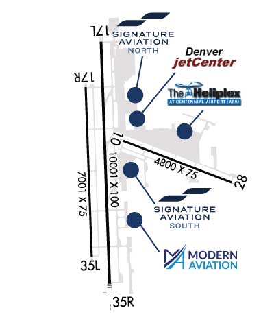
| ALL ACFT BLO CERTIFICATED 70000 LB MAX GROSS TKOF WT & STAGE III ACFT UP TO CERTIFICATED 75000 LB MAX GROSS TKOF WT MAY BE OPERATED; ONE-TIME EXCEPTIONS MAY BE AUZD BY EXEC DIR ON A CASE-BY-CASE BASIS. |
| NUMEROUS FLOOD LGTS LCTD 1/2 SM N OF THLD RY 17L SS-2400. |
| HELICOPTER OPS PLEASE CONTACT PREFERRED FBO FOR LANDING ZONE LOCATIONS. HELICOPTER OPS ON FRONT RAMP NOT ADVISED. |
| 24 HR. USER FEE CUSTOMS AVAILABLE. CONTACT AIRPORT FOR FEE INFORMATION. |
| NOISE ABATEMENT PROCEDURES IN EFFECT; CTC NOISE OFFICE 303-790-0598. |
| ADVISORY DENSITY ALTITUDE DISPLAYS LOCATED AT C-1,A-1, AND A-18. |
| TWY S2 CLSD INDEFINATELY |
| WATERFOWL ON & INVOF ARPT. |
| NMRS CRANES INVOF ARPT. |
| +190 FT TWR LCTD 1800 FT ENE OF RY 17L THLD. |
| RY 35R-CROSSWIND/BASE LEG NORTH OF LINCOLN AVE RY 17L CROSSWIND/BASE LEG SOUTH OF ARAPAHOE ROAD. RY 17R/35L CLSD TFC REMAIN S OF ARAPAHOE ROAD & E OF INTERSTATE 25. RY 10/28 AVOID NOISE SENSITIVE AREAS 1 MILE E & S OF RY. |
| RWY H1 TLOF LENGTH 50 FT; WIDTH 50 FT; FATO LENGTH 50 FT; WIDTH 50 FT; INGRESS/EGRESS 270 DEGREES. |
| RWY H1 HELI SVC 24 HRS CTC 303-799-0079. |
Airport Communications & Frequencies:
| |||||||||||||||||||||||||||
| Runway: 10 | Runway: 28 | ||
| Mag heading: | 103° | Mag heading: | 283° |
| Rwy Slope: | -.63% Down | Rwy Slope: | .63% Up |
| Approach: | Approach: | ||
| Pattern: | Left Traffic | Pattern: | Left Traffic |
| Markings: | NONPRECISION INSTRUMENT | Markings: | NONPRECISION INSTRUMENT |
| Marking Condition: | GOOD | Marking Condition: | GOOD |
| Arresting Dev: | Arresting Dev: | ||
| Lat & Long: | N3934.4 W10450.9 | Lat. & Long.: | N3934.1 W10449.9 |
| Elev: | 5824.1 ft. MSL | Elev: | 5793.8 ft. MSL |
| TCH: | 44 ft. AGL | TCH: | 41 ft. AGL |
| Visual Glide Path: | 3.00 degrees | Visual Glide Path: | 3.00 degrees |
| Displaced Threshold: | 400 feet | Displaced Threshold: | No |
| Touchdown Zone: | YES | Touchdown Zone: | YES |
| Touchdown Elev.: | 5821.6 feet | Touchdown Elev.: | 5812.7 feet |
| Visual Glide Slope: | 2-Light PAPI on LEFT side of Runway | Visual Glide Slope: | 2-Light PAPI on LEFT side of Runway |
| RVR Equipment: | RVR Equipment: | ||
| RVV Equipment: | NO | RVV Equipment: | NO |
| Approach Lights: | Approach Lights: | ||
| REIL: | NO | REIL: | YES |
| Centerline Lights: | NO | Centerline Lights: | NO |
| Touchdown lights: | NO | Touchdown lights: | NO |
| Runway Category: | Runway with a Visual Approach | Runway Category: | Runway with a Non-precision Approach |
| Declared Distances: | Declared Distances: | ||
| Obstructions: | Obstructions: | POLE | |
| Marked: | Marked: | NOT Marked/Lighted | |
| Clearance slope: | 20:1 | Clearance slope: | 25:1 |
| Obstruction height: | Obstruction height: | 54 feet AGL | |
| Dist. from runway: | Dist. from runway: | 1596 feet | |
| Centerline offset: | Centerline offset: | 414 feet left of centerline | |
| Comments: | Comments: |
| Runway: 17L | Runway: 35R | ||
| Mag heading: | 170° | Mag heading: | 350° |
| Rwy Slope: | .92% Up | Rwy Slope: | -.92% Down |
| Approach: | Approach: | ILS/DME | |
| Pattern: | Left Traffic | Pattern: | Right Traffic |
| Markings: | PRECISION INSTRUMENT | Markings: | PRECISION INSTRUMENT |
| Marking Condition: | GOOD | Marking Condition: | GOOD |
| Arresting Dev: | Arresting Dev: | ||
| Lat & Long: | N3935.0 W10451.1 | Lat. & Long.: | N3933.4 W10451.0 |
| Elev: | 5793.0 ft. MSL | Elev: | 5884.9 ft. MSL |
| TCH: | 47 ft. AGL | TCH: | 49 ft. AGL |
| Visual Glide Path: | 3.00 degrees | Visual Glide Path: | 3.00 degrees |
| Displaced Threshold: | No | Displaced Threshold: | No |
| Touchdown Zone: | YES | Touchdown Zone: | YES |
| Touchdown Elev.: | 5823.0 feet | Touchdown Elev.: | 5884.9 feet |
| Visual Glide Slope: | 4-Light PAPI on LEFT side of Runway | Visual Glide Slope: | 4-Light PAPI on LEFT side of Runway |
| RVR Equipment: | RVR Equipment: | ||
| RVV Equipment: | NO | RVV Equipment: | NO |
| Approach Lights: | Approach Lights: | MALSR - 1,400 foot medium intensity approach lighting system with runway alignment indicator lights | |
| REIL: | NO | REIL: | NO |
| Centerline Lights: | NO | Centerline Lights: | NO |
| Touchdown lights: | NO | Touchdown lights: | NO |
| Runway Category: | Precision Instrument Runway | Runway Category: | Precision Instrument Runway |
| Declared Distances: | Declared Distances: | ||
| Obstructions: | Obstructions: | PLINE | |
| Marked: | Marked: | LIGHTED | |
| Clearance slope: | 50:1 | Clearance slope: | 32:1 |
| Obstruction height: | Obstruction height: | 542 feet AGL | |
| Dist. from runway: | Dist. from runway: | 17874 feet | |
| Centerline offset: | Centerline offset: | 2716 feet left of centerline | |
| Comments: | Comments: |
| Runway: 17R | Runway: 35L | ||
| Mag heading: | 170° | Mag heading: | 350° |
| Rwy Slope: | .93% Up | Rwy Slope: | -.93% Down |
| Approach: | Approach: | ||
| Pattern: | Right Traffic | Pattern: | Left Traffic |
| Markings: | NONPRECISION INSTRUMENT | Markings: | NONPRECISION INSTRUMENT |
| Marking Condition: | GOOD | Marking Condition: | GOOD |
| Arresting Dev: | Arresting Dev: | ||
| Lat & Long: | N3934.7 W10451.2 | Lat. & Long.: | N3933.6 W10451.2 |
| Elev: | 5803.7 ft. MSL | Elev: | 5868.7 ft. MSL |
| TCH: | 41 ft. AGL | TCH: | 37 ft. AGL |
| Visual Glide Path: | 3.00 degrees | Visual Glide Path: | 3.00 degrees |
| Displaced Threshold: | No | Displaced Threshold: | No |
| Touchdown Zone: | YES | Touchdown Zone: | YES |
| Touchdown Elev.: | 5833.6 feet | Touchdown Elev.: | 5868.7 feet |
| Visual Glide Slope: | 4-Light PAPI on LEFT side of Runway | Visual Glide Slope: | 4-Light PAPI on RIGHT side of Runway |
| RVR Equipment: | RVR Equipment: | ||
| RVV Equipment: | NO | RVV Equipment: | NO |
| Approach Lights: | Approach Lights: | ||
| REIL: | YES | REIL: | YES |
| Centerline Lights: | NO | Centerline Lights: | NO |
| Touchdown lights: | NO | Touchdown lights: | NO |
| Runway Category: | Runway with a Visual Approach | Runway Category: | Runway with a Visual Approach |
| Declared Distances: | Declared Distances: | ||
| Obstructions: | Obstructions: | FENCE | |
| Marked: | Marked: | NOT Marked/Lighted | |
| Clearance slope: | 50:1 | Clearance slope: | 20:1 |
| Obstruction height: | Obstruction height: | 16 feet AGL | |
| Dist. from runway: | Dist. from runway: | 527 feet | |
| Centerline offset: | Centerline offset: | 215 feet left of centerline | |
| Comments: | Comments: |
Thanks for using FltPlan.com
all rights reserved © 1999-2021 by Flight Plan LLC