
| AVA BILL MARTIN MEMORIAL AVA MO |
| |
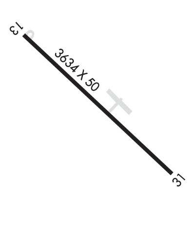
| Lat: N 3658.3 Long: W 09240.9 Elev: 1311 Var: -02 Longest Runway: 3634 | ||
| CTAF: 122.7 | ||
| |||||||||||||||||||||||||||||||||||||||||||||||||||||||||||||
| |||||||||||||||||||||||||||||||||||||||||||||||||||||||||||||
| Rwy | Rwy | |||||||
| 3634x50 | 3634' | 3634x50 | 3634' | |||||
| Runway ID | Single Wheel | Double Wheel | Double Tandem Wheel | Dual Double Wheel |
| 13/31 | N/A | N/A | N/A | N/A |
| These numbers are Advisory and are not limits. The Airport Manager should have more accurate Weight Limits | ||||
 Airport Diagram might not be current. | |
| Facility Name: | AVA BILL MARTIN MEML |
| City Name: | AVA |
| County: | DOUGLAS |
| State abbrev: | MO |
| State Name: | MISSOURI |
| Ownership: | PUBLICLY OWNED |
| Use: | OPEN TO THE PUBLIC |
| Owner's Name: | CITY OF AVA |
| Address: | 404 SOUTH JEFFERSON ST, P.O. BOX 967 |
| AVA, MO 65608 | |
| Owner's Phone: | 417-683-5516 |
| Manager's Name: | DAVID DAVIDSON |
| Address: | PO BOX 967 |
| AVA, MO 65608 | |
| Phone: | 417-683-3169 |
| FAA Region: | CENTRAL |
| FAA Field Office: | NONE |
| Date | Sunrise | Sunset |
|---|---|---|
| 09/24/21 Friday | 7:00 | 19:05 |
| 09/25/21 Saturday | 7:01 | 19:03 |
| 09/26/21 Sunday | 7:02 | 19:02 |
| 09/27/21 Monday | 7:02 | 19:00 |
| 09/28/21 Tuesday | 7:03 | 18:59 |
| 09/29/21 Wednesday | 7:04 | 18:57 |
| 09/30/21 Thursday | 7:05 | 18:56 |
| 10/01/21 Friday | 7:06 | 18:54 |
| 10/02/21 Saturday | 7:07 | 18:53 |
| 10/03/21 Sunday | 7:08 | 18:51 |
| 10/04/21 Monday | 7:08 | 18:50 |
| 10/05/21 Tuesday | 7:09 | 18:48 |
| 10/06/21 Wednesday | 7:10 | 18:47 |
| 10/07/21 Thursday | 7:11 | 18:46 |
| Airport Attendance Schedule | UNATTENDED |
| Airport Status | OPERATIONAL (This Status can change at any time - please check NOTAMS) |
| Airport Lighting Schedule | ACTVT MIRL RY 13/31 - CTAF. |
| Airport Storage Available | Tie Downs |
| Extra Services Available | Flight Instruction, Aircraft Rental |
| Wind Indicator | YES - (lighted) |
| Control Tower | NO |
| CTAF Frequency | 122.700 |
| Unicom Frequency | 122.700 |
| Rotating Beacon Color | CLEAR-GREEN (Light Land Airport) |
| Segmented Circle | Y-L |
| Landing Fee | NO |
| Airport Inspected | STATE - performed by STATE AERONAUTICAL PERSONNEL |
| Inspection Date | 08/13/2019 |
| Type of Fuel Available | Grade 100LL |
| Airframe Repair Service | MAJOR |
| Power Plant Repair Service | MAJOR |
| Latitude | N3658.3 |
| Longitude | W09240.9 (ESTIMATED) |
| Arpt Elevation | 1311ft (SURVEYED) |
| Magnetic Variation | 02E |
| 2 miles NW | of AVA |
| Traffic Pattern Altitude | |
| Sectional Chart | KANSAS CITY |
| Operations (Reported) | Yearly | Avg. Daily |
|---|---|---|
| General Aviation Transient | 1210 | 3 |
| General Aviation Local | 4860 | 13 |
| Air Taxi | 32 | 0 |
| Commerical | 0 | 0 |
| Commuter | 0 | 0 |
| Military | 520 | 1 |
| Aircraft based on Field | |
|---|---|
| General Aviation Singles | 8 |
| General Aviation Multi | 2 |
| Jet Aircraft | 0 |
| General Aviation Helicopters | 0 |
| Military Aircraft | 0 |
| Gliders | 0 |
| Ultralights | 0 |
| FSS on field | NO |
| FSS tie-in | COLUMBIA |
| FSS Phone | 1-800-WX-BRIEF |
| Who issues Notams | COU |
| Notam D service at airport | YES |
| ARTCC Name | KANSAS CITY |
| Airport Certification | |
| Aircraft Rescue & Firefighting Index | None |
| Airport of Entry | No |
| Custom Landing Rights | No |
| Joint Civil/Military | No |
| Military Landing rights | No |
| THIS AIRPORT HAS BEEN SURVEYED BY THE NATIONAL GEODETIC SURVEY. |
| NTSD RY SAFETY AREA BYD RY 13 END, INSUF LENGTH AND LARGE DROP OFF. |
| 100LL SELF SVC CREDIT CARD AVBL 24 HRS. |
| CLICK PCL 5 TIMES TO UNLOCK TERMINAL DOOR. |
| FOR CD CTC SPRINGFIELD APCH AT 417-868-5620/5619. |
Airport Communications & Frequencies:
|
| Runway: 13 | Runway: 31 | ||
| Mag heading: | 135° | Mag heading: | 315° |
| Rwy Slope: | .94% Up | Rwy Slope: | -.94% Down |
| Approach: | Approach: | ||
| Pattern: | Left Traffic | Pattern: | Left Traffic |
| Markings: | NONPRECISION INSTRUMENT | Markings: | NONPRECISION INSTRUMENT |
| Marking Condition: | GOOD | Marking Condition: | GOOD |
| Arresting Dev: | Arresting Dev: | ||
| Lat & Long: | N3658.5 W09241.2 | Lat. & Long.: | N3658.1 W09240.7 |
| Elev: | 1277.0 ft. MSL | Elev: | 1311.0 ft. MSL |
| TCH: | 34 ft. AGL | TCH: | |
| Visual Glide Path: | 3.00 degrees | Visual Glide Path: | |
| Displaced Threshold: | No | Displaced Threshold: | No |
| Touchdown Zone: | YES | Touchdown Zone: | YES |
| Touchdown Elev.: | 1277.0 feet | Touchdown Elev.: | 1311.0 feet |
| Visual Glide Slope: | 2-BOX SIMPLIFIED ABBREVIATED VISUAL APPROACH SLOPE INDICATOR ON LEFT SIDE OF RUNWAY | Visual Glide Slope: | |
| RVR Equipment: | RVR Equipment: | ||
| RVV Equipment: | NO | RVV Equipment: | NO |
| Approach Lights: | Approach Lights: | ||
| REIL: | NO | REIL: | NO |
| Centerline Lights: | NO | Centerline Lights: | NO |
| Touchdown lights: | NO | Touchdown lights: | NO |
| Runway Category: | Runway with a Non-precision Approach | Runway Category: | Runway with a Non-precision Approach |
| Declared Distances: | Declared Distances: | ||
| Obstructions: | TREES | Obstructions: | |
| Marked: | NOT Marked/Lighted | Marked: | |
| Clearance slope: | 1:1 | Clearance slope: | 20:1 |
| Obstruction height: | 33 feet AGL | Obstruction height: | |
| Dist. from runway: | 235 feet | Dist. from runway: | |
| Centerline offset: | 197 right of centerline | Centerline offset: | |
| Comments: | TREES 10-35' TALL, 10-175' FROM RUNWAY END, 150-250 FT RIGHT | Comments: |
Thanks for using FltPlan.com
all rights reserved © 1999-2021 by Flight Plan LLC

