
| ARCO-BUTTE COUNTY ARCO ID |
| |
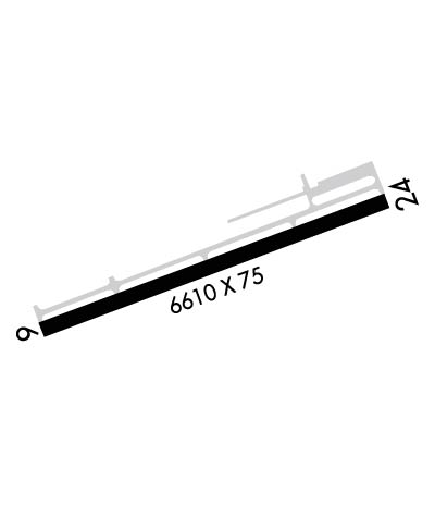
| Lat: N 4336.2 Long: W 11320.1 Elev: 5335 Var: -15 Longest Runway: 6610 | ||
| AWOS: 135.42 CTAF: 122.8 | ||
| ||||||
| ||||||
|
| Rwy | Rwy | |||||||
| 6610x75 | 6610' | 6610x75 | 6610' | |||||
| Runway ID | Single Wheel | Double Wheel | Double Tandem Wheel | Dual Double Wheel |
| 06/24 | 300,000 | N/A | N/A | N/A |
| These numbers are Advisory and are not limits. The Airport Manager should have more accurate Weight Limits | ||||
 Airport Diagram might not be current. | |
| Facility Name: | ARCO-BUTTE COUNTY |
| City Name: | ARCO |
| County: | BUTTE |
| State abbrev: | ID |
| State Name: | IDAHO |
| Ownership: | PUBLICLY OWNED |
| Use: | OPEN TO THE PUBLIC |
| Owner's Name: | CITY OF ARCO AND BUTTE COUNTY; BUTTE CO ADDRESS AND TELEPHONE NO. |
| Address: | PO BOX 196 |
| ARCO, ID 83213 | |
| Owner's Phone: | (208) 227-4646 |
| Manager's Name: | AIRPORT BOARD OF DIRS (TJ PARK) |
| Address: | BOX 196 |
| ARCO, ID 83213 | |
| Phone: | (208) 227-4646 |
| FAA Region: | NORTHWEST MOUNTAIN |
| FAA Field Office: | HLN |

| Date | Sunrise | Sunset |
|---|---|---|
| 09/24/21 Friday | 7:23 | 19:27 |
| 09/25/21 Saturday | 7:24 | 19:26 |
| 09/26/21 Sunday | 7:25 | 19:24 |
| 09/27/21 Monday | 7:26 | 19:22 |
| 09/28/21 Tuesday | 7:27 | 19:20 |
| 09/29/21 Wednesday | 7:28 | 19:18 |
| 09/30/21 Thursday | 7:29 | 19:16 |
| 10/01/21 Friday | 7:31 | 19:15 |
| 10/02/21 Saturday | 7:32 | 19:13 |
| 10/03/21 Sunday | 7:33 | 19:11 |
| 10/04/21 Monday | 7:34 | 19:09 |
| 10/05/21 Tuesday | 7:35 | 19:07 |
| 10/06/21 Wednesday | 7:36 | 19:06 |
| 10/07/21 Thursday | 7:38 | 19:04 |
| Airport Attendance Schedule | 7 Days A Week 0800-2000 |
| Airport Status | OPERATIONAL (This Status can change at any time - please check NOTAMS) |
| Airport Lighting Schedule | ACTVT MIRL RY 06/24, REIL RYS 06 & 24 AND PAPI RYS 06 & 24 - CTAF. |
| Airport Storage Available | Tie Downs |
| Extra Services Available | NONE |
| Wind Indicator | YES - (lighted) |
| Control Tower | NO |
| CTAF Frequency | 122.800 |
| Unicom Frequency | 122.800 |
| Rotating Beacon Color | CLEAR-GREEN (Light Land Airport) |
| Segmented Circle | NO |
| Landing Fee | NO |
| Airport Inspected | STATE - performed by STATE AERONAUTICAL PERSONNEL |
| Inspection Date | 07/12/2021 |
| Type of Fuel Available | Grade 100LL; -10100LL ONLY AVAILABLE WHEN ATTENDED. PLS CALL MGR ON DUTY; PHONE NR. LISTED ON THE DOOR OF THE OFFICE. |
| Airframe Repair Service | NONE |
| Power Plant Repair Service | NONE |
| Latitude | N4336.2 |
| Longitude | W11320.1 (ESTIMATED) |
| Arpt Elevation | 5335ft (SURVEYED) |
| Magnetic Variation | 15E |
| 3 miles SW | of ARCO |
| Traffic Pattern Altitude | |
| Sectional Chart | SALT LAKE CITY |
| Operations (Reported) | Yearly | Avg. Daily |
|---|---|---|
| General Aviation Transient | 6000 | 16 |
| General Aviation Local | 1000 | 3 |
| Air Taxi | 100 | 0 |
| Commerical | 0 | 0 |
| Commuter | 0 | 0 |
| Military | 50 | 0 |
| Aircraft based on Field | |
|---|---|
| General Aviation Singles | 4 |
| General Aviation Multi | 0 |
| Jet Aircraft | 0 |
| General Aviation Helicopters | 0 |
| Military Aircraft | 0 |
| Gliders | 0 |
| Ultralights | 0 |
| FSS on field | NO |
| FSS tie-in | BOISE |
| FSS Phone | 1-800-WX-BRIEF |
| Who issues Notams | BOI |
| Notam D service at airport | YES |
| ARTCC Name | SALT LAKE CITY |
| Airport Certification | |
| Aircraft Rescue & Firefighting Index | None |
| Airport of Entry | No |
| Custom Landing Rights | No |
| Joint Civil/Military | No |
| Military Landing rights | YES |
| NATIONAL PLAN OF INTEGRATED AIRPORT SYSTEMS (NPIAS) |
| GRANT AGREEMENTS UNDER FAAP/ADAP/AIP |
| CONVEYANCE UNDER SCETION 16, FEDERAL AIRPORT ACT OF 1946 OR SECTION 23, AIRPORT AND AIRWAY DEVELOPMENT ACT OF 1970 |
| ASSURANCES PURSUANT TO TITLE VI, CIVIL RIGHTS ACT OF 1964 |
| ALL INCOMING AND DEPARTING TRAFFIC SHOULD USE A LEFT HAND (LH) TRAFFIC PATTERN; PATTERN ALTITUDE IS 1000' AGL. |
| FOR CD CTC SALT LAKE ARTCC AT 801-320-2568. |
Airport Communications & Frequencies:
| |||||||||
| Runway: 06 | Runway: 24 | ||
| Mag heading: | 55° | Mag heading: | 235° |
| Rwy Slope: | -.11% Down | Rwy Slope: | .11% Up |
| Approach: | Approach: | ||
| Pattern: | Left Traffic | Pattern: | Left Traffic |
| Markings: | NONPRECISION INSTRUMENT | Markings: | NONPRECISION INSTRUMENT |
| Marking Condition: | FAIR | Marking Condition: | FAIR |
| Arresting Dev: | Arresting Dev: | ||
| Lat & Long: | N4336.0 W11320.8 | Lat. & Long.: | N4336.4 W11319.4 |
| Elev: | 5335.3 ft. MSL | Elev: | 5327.9 ft. MSL |
| TCH: | 40 ft. AGL | TCH: | 40 ft. AGL |
| Visual Glide Path: | 3.00 degrees | Visual Glide Path: | 3.00 degrees |
| Displaced Threshold: | No | Displaced Threshold: | No |
| Touchdown Zone: | YES | Touchdown Zone: | YES |
| Touchdown Elev.: | 5335.4 feet | Touchdown Elev.: | 5332.4 feet |
| Visual Glide Slope: | 2-Light PAPI on LEFT side of Runway; PAPI RYS 06 & 24 OTS INDEFLY. | Visual Glide Slope: | 2-Light PAPI on LEFT side of Runway |
| RVR Equipment: | RVR Equipment: | ||
| RVV Equipment: | NO | RVV Equipment: | NO |
| Approach Lights: | Approach Lights: | ||
| REIL: | YES | REIL: | YES |
| Centerline Lights: | NO | Centerline Lights: | NO |
| Touchdown lights: | NO | Touchdown lights: | NO |
| Runway Category: | Runway with a Visual Approach | Runway Category: | Runway with a Visual Approach |
| Declared Distances: | Declared Distances: | ||
| Obstructions: | Obstructions: | PLINE | |
| Marked: | Marked: | NOT Marked/Lighted | |
| Clearance slope: | 20:1 | Clearance slope: | 45:1 |
| Obstruction height: | Obstruction height: | 35 feet AGL | |
| Dist. from runway: | Dist. from runway: | 1800 feet | |
| Centerline offset: | Centerline offset: | ||
| Comments: | Comments: |
Thanks for using FltPlan.com
all rights reserved © 1999-2021 by Flight Plan LLC