
| AINSWORTH MUNI AINSWORTH NE |
| |
| Lat: N 4234.8 Long: W 09959.6 Elev: 2589 Var: -06 Longest Runway: 6824 | ||
| AWOS: 118.32 CTAF: 122.8 | ||
| ||||||||||||||||||||||||||||||||||||||||||||
| ||||||||||||||||||||||||||||||||||||||||||||
| ||||||||||||||||||||||||||||||||||||||||||||
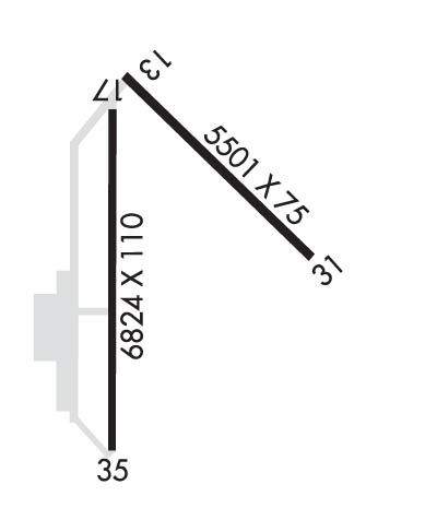
| Rwy | Rwy | |||||||
| 5501x75 | 5501' | 5501x75 | 5501' | |||||
| 6824x110 | 6824' | 6824x110 | 6824' | |||||
| Runway ID | Single Wheel | Double Wheel | Double Tandem Wheel | Dual Double Wheel |
| 13/31 | 24,000 | 36,000 | N/A | N/A |
| 17/35 | 30,000 | 45,000 | N/A | N/A |
| H1 | N/A | N/A | N/A | N/A |
| These numbers are Advisory and are not limits. The Airport Manager should have more accurate Weight Limits | ||||
 Airport Diagram might not be current. | |
| Facility Name: | AINSWORTH RGNL |
| City Name: | AINSWORTH |
| County: | BROWN |
| State abbrev: | NE |
| State Name: | NEBRASKA |
| Ownership: | PUBLICLY OWNED |
| Use: | OPEN TO THE PUBLIC |
| Owner's Name: | AINSWORTH ARPT AUTH |
| Address: | PO BOX 84 |
| AINSWORTH, NE 69210-0084 | |
| Owner's Phone: | 402-387-1491; ARPT MGR. |
| Manager's Name: | LANCE SCHIPPOREIT |
| Address: | PO BOX 84 |
| AINSWORTH, NE 69210-0084 | |
| Phone: | 402-387-1491; AMGR HOME PHONE 402-387-1255/1-800-303-1491. ON CALL. |
| FAA Region: | CENTRAL |
| FAA Field Office: | NONE |
| Date | Sunrise | Sunset |
|---|---|---|
| 09/24/21 Friday | 7:29 | 19:34 |
| 09/25/21 Saturday | 7:30 | 19:32 |
| 09/26/21 Sunday | 7:31 | 19:30 |
| 09/27/21 Monday | 7:32 | 19:29 |
| 09/28/21 Tuesday | 7:34 | 19:27 |
| 09/29/21 Wednesday | 7:35 | 19:25 |
| 09/30/21 Thursday | 7:36 | 19:23 |
| 10/01/21 Friday | 7:37 | 19:22 |
| 10/02/21 Saturday | 7:38 | 19:20 |
| 10/03/21 Sunday | 7:39 | 19:18 |
| 10/04/21 Monday | 7:40 | 19:16 |
| 10/05/21 Tuesday | 7:41 | 19:15 |
| 10/06/21 Wednesday | 7:42 | 19:13 |
| 10/07/21 Thursday | 7:44 | 19:11 |
| Airport Attendance Schedule | MON-FRI 0800-1700 |
| Airport Status | OPERATIONAL (This Status can change at any time - please check NOTAMS) |
| Airport Lighting Schedule | ACTVT HIRL RYS 17/35 & 13/31; VASI RYS 13 & 31; MALSR RYS 17 & 35 AND PAPI RYS 17 & 35 & REIL RY 31 - CTAF. |
| Airport Storage Available | Tie Downs, Hanger |
| Extra Services Available | Flight Instruction |
| Wind Indicator | YES - (lighted) |
| Control Tower | NO |
| CTAF Frequency | 122.800 |
| Unicom Frequency | 122.800 |
| Rotating Beacon Color | CLEAR-GREEN (Light Land Airport) |
| Segmented Circle | YES |
| Landing Fee | NO |
| Airport Inspected | STATE - performed by STATE AERONAUTICAL PERSONNEL |
| Inspection Date | 06/25/2020 |
| Type of Fuel Available | Grade 100LL, JET A (freeze point -40C); -1024 HR SELF SVC FUEL AVBL VIA CREDIT CARD SYSTEM. |
| Airframe Repair Service | NONE |
| Power Plant Repair Service | NONE |
| Latitude | N4234.8 |
| Longitude | W09959.6 (ESTIMATED) |
| Arpt Elevation | 2588ft (SURVEYED) |
| Magnetic Variation | 06E |
| 6 miles NW | of AINSWORTH |
| Traffic Pattern Altitude | |
| Sectional Chart | OMAHA |
| Operations (Reported) | Yearly | Avg. Daily |
|---|---|---|
| General Aviation Transient | 2650 | 7 |
| General Aviation Local | 1300 | 4 |
| Air Taxi | 0 | 0 |
| Commerical | 0 | 0 |
| Commuter | 0 | 0 |
| Military | 50 | 0 |
| Aircraft based on Field | |
|---|---|
| General Aviation Singles | 11 |
| General Aviation Multi | 1 |
| Jet Aircraft | 1 |
| General Aviation Helicopters | 2 |
| Military Aircraft | 0 |
| Gliders | 0 |
| Ultralights | 0 |
| FSS on field | NO |
| FSS tie-in | COLUMBUS |
| FSS Phone | 1-800-WX-BRIEF |
| Who issues Notams | ANW |
| Notam D service at airport | YES |
| ARTCC Name | DENVER |
| Airport Certification | |
| Aircraft Rescue & Firefighting Index | None |
| Airport of Entry | No |
| Custom Landing Rights | No |
| Joint Civil/Military | No |
| Military Landing rights | YES |
| NATIONAL PLAN OF INTEGRATED AIRPORT SYSTEMS (NPIAS) |
| GRANT AGREEMENTS UNDER FAAP/ADAP/AIP |
| SURPLUS PROPERTY AGREEMENT UNDER PUBLIC LAW 289 |
| ASSURANCES PURSUANT TO TITLE VI, CIVIL RIGHTS ACT OF 1964 |
| HELIPAD FOR REFUELING ONLY. NOT AVBL FOR INST APCHS. |
| SEASONAL MIGRATORY WATERFOWL ON & INVOF ARPT. |
| FOR CD IF UNA TO CTC ON FSS FREQ, CTC DENVER ARTCC AT 303-651-4257. |
Airport Communications & Frequencies:
| |||||||||
| Runway: 13 | Runway: 31 | ||
| Mag heading: | 128° | Mag heading: | 308° |
| Rwy Slope: | -.07% Down | Rwy Slope: | .07% Up |
| Approach: | Approach: | ||
| Pattern: | Left Traffic | Pattern: | Left Traffic |
| Markings: | NONPRECISION INSTRUMENT | Markings: | NONPRECISION INSTRUMENT |
| Marking Condition: | GOOD | Marking Condition: | FAIR |
| Arresting Dev: | Arresting Dev: | ||
| Lat & Long: | N4235.3 W09959.8 | Lat. & Long.: | N4234.6 W09958.9 |
| Elev: | 2586.7 ft. MSL | Elev: | 2582.6 ft. MSL |
| TCH: | 50 ft. AGL | TCH: | 52 ft. AGL |
| Visual Glide Path: | 3.00 degrees | Visual Glide Path: | 3.00 degrees |
| Displaced Threshold: | No | Displaced Threshold: | No |
| Touchdown Zone: | YES | Touchdown Zone: | YES |
| Touchdown Elev.: | 2586.9 feet | Touchdown Elev.: | 2584.8 feet |
| Visual Glide Slope: | 2-Box VASI on LEFT side of Runway | Visual Glide Slope: | 2-Box VASI on LEFT side of Runway |
| RVR Equipment: | RVR Equipment: | ||
| RVV Equipment: | NO | RVV Equipment: | NO |
| Approach Lights: | Approach Lights: | ||
| REIL: | NO | REIL: | YES |
| Centerline Lights: | NO | Centerline Lights: | NO |
| Touchdown lights: | NO | Touchdown lights: | NO |
| Runway Category: | Runway with a Non-precision Approach having visibility minimums greater than 3/4 mile | Runway Category: | Runway with a Non-precision Approach having visibility minimums greater than 3/4 mile |
| Declared Distances: | Declared Distances: |
| Runway: 17 | Runway: 35 | ||
| Mag heading: | 173° | Mag heading: | 353° |
| Rwy Slope: | .03% Up | Rwy Slope: | -.03% Down |
| Approach: | Approach: | ||
| Pattern: | Left Traffic | Pattern: | Left Traffic |
| Markings: | PRECISION INSTRUMENT | Markings: | PRECISION INSTRUMENT |
| Marking Condition: | GOOD | Marking Condition: | GOOD |
| Arresting Dev: | Arresting Dev: | ||
| Lat & Long: | N4235.2 W09959.8 | Lat. & Long.: | N4234.0 W09959.8 |
| Elev: | 2586.5 ft. MSL | Elev: | 2588.4 ft. MSL |
| TCH: | 46 ft. AGL | TCH: | 45 ft. AGL |
| Visual Glide Path: | 3.00 degrees | Visual Glide Path: | 3.00 degrees |
| Displaced Threshold: | No | Displaced Threshold: | No |
| Touchdown Zone: | YES | Touchdown Zone: | YES |
| Touchdown Elev.: | 2588.7 feet | Touchdown Elev.: | 2588.6 feet |
| Visual Glide Slope: | 4-Light PAPI on LEFT side of Runway | Visual Glide Slope: | 4-Light PAPI on LEFT side of Runway |
| RVR Equipment: | RVR Equipment: | ||
| RVV Equipment: | NO | RVV Equipment: | NO |
| Approach Lights: | MALSR - 1,400 foot medium intensity approach lighting system with runway alignment indicator lights | Approach Lights: | MALSR - 1,400 foot medium intensity approach lighting system with runway alignment indicator lights |
| REIL: | NO | REIL: | NO |
| Centerline Lights: | NO | Centerline Lights: | NO |
| Touchdown lights: | NO | Touchdown lights: | NO |
| Runway Category: | Precision Instrument Runway | Runway Category: | Precision Instrument Runway |
| Declared Distances: | Declared Distances: | ||
| Obstructions: | BERM | Obstructions: | TREES |
| Marked: | NOT Marked/Lighted | Marked: | NOT Marked/Lighted |
| Clearance slope: | 32:1 | Clearance slope: | 39:1 |
| Obstruction height: | 5 feet AGL; BERM IS ACTUALLY 4.5 FT; WHICH GIVES THE 32:1 OBSTN CLNC SLOPE. | Obstruction height: | 44 feet AGL |
| Dist. from runway: | 347 feet | Dist. from runway: | 1937 feet |
| Centerline offset: | 522 right of centerline | Centerline offset: | 670 feet right of centerline |
| Comments: | Comments: |
Thanks for using FltPlan.com
all rights reserved © 1999-2021 by Flight Plan LLC
