| LEE ANNAPOLIS MD |
| |
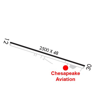
| Lat: N 3856.6 Long: W 07634.1 Elev: 34 Var: +10 Longest Runway: 2505 | ||
| CTAF: 122.9 | ||
| |||||||||||||||||||||||
| |||||||||||||||||||||||
| Rwy | Rwy | |||||||
| 2505x48 | 2029' | 2505x48 | 2179' | |||||
| Runway ID | Single Wheel | Double Wheel | Double Tandem Wheel | Dual Double Wheel |
| 12/30 | N/A | N/A | N/A | N/A |
| These numbers are Advisory and are not limits. The Airport Manager should have more accurate Weight Limits | ||||
 Airport Diagram might not be current. | |
| Facility Name: | LEE |
| City Name: | ANNAPOLIS |
| County: | ANNE ARUNDEL |
| State abbrev: | MD |
| State Name: | MARYLAND |
| Ownership: | PRIVATELY OWNED |
| Use: | OPEN TO THE PUBLIC |
| Owner's Name: | LEE AIRPORT AUTHORITY LLC; CORPORATION ESTABLISHED BY MARY C. LEE |
| Address: | P.O. BOX 2342 |
| ANNAPOLIS, MD 21401 | |
| Owner's Phone: | 410-956-1280 |
| Manager's Name: | LEE RUNWAY MANAGER LLC |
| Address: | P.O. BOX 2342 |
| ANNAPOLIS, MD 21401 | |
| Phone: | 410-956-1280 |
| FAA Region: | EASTERN |
| FAA Field Office: | DCA |
| Date | Sunrise | Sunset |
|---|---|---|
| 06/07/26 Sunday | 5:41 | 20:30 |
| 06/08/26 Monday | 5:41 | 20:30 |
| 06/09/26 Tuesday | 5:41 | 20:31 |
| 06/10/26 Wednesday | 5:40 | 20:31 |
| 06/11/26 Thursday | 5:40 | 20:32 |
| 06/12/26 Friday | 5:40 | 20:32 |
| 06/13/26 Saturday | 5:40 | 20:33 |
| 06/14/26 Sunday | 5:40 | 20:33 |
| 06/15/26 Monday | 5:40 | 20:33 |
| 06/16/26 Tuesday | 5:40 | 20:34 |
| 06/17/26 Wednesday | 5:40 | 20:34 |
| 06/18/26 Thursday | 5:40 | 20:34 |
| 06/19/26 Friday | 5:41 | 20:35 |
| 06/20/26 Saturday | 5:41 | 20:35 |
| Airport Attendance Schedule | 7 Days A Week 0800-1600; CONTACT AIRPORT MANAGER 410-956-1280 FOR APPROVAL OF ANY FLIGHT OPERATIONS BETWEEN 2200 - 0700 LOCAL. ARPT UNATNDD NEW YEARS; MEMORIAL DAY; JULY 4; LABOR DAY; THANKSGIVING & CHRISTMAS. |
| Airport Status | OPERATIONAL (This Status can change at any time - please check NOTAMS) |
| Airport Lighting Schedule | ACTVT LIRL RWY 12/30 - CTAF. LIGHTING INOP BTW 2200-0700.; DUSK-2200. |
| Airport Storage Available | Tie Downs |
| Extra Services Available | Flight Instruction, Aircraft Rental |
| Wind Indicator | YES - (lighted) |
| Control Tower | NO |
| CTAF Frequency | 122.900 |
| Unicom Frequency | |
| Rotating Beacon Color | WG |
| Segmented Circle | NO |
| Landing Fee | YES |
| Airport Inspected | STATE - performed by STATE AERONAUTICAL PERSONNEL |
| Inspection Date | 04/15/2026 |
| Type of Fuel Available | Grade 100LL |
| Airframe Repair Service | MAJOR |
| Power Plant Repair Service | MAJOR |
| Latitude | N3856.6 |
| Longitude | W07634.1 (ESTIMATED) |
| Arpt Elevation | 34ft (ESTIMATED) |
| Magnetic Variation | 10W |
| 5 miles SW | of ANNAPOLIS |
| Traffic Pattern Altitude | |
| Sectional Chart | WASHINGTON |
| Operations (Reported) | Yearly | Avg. Daily |
|---|---|---|
| General Aviation Transient | 0 | 0 |
| General Aviation Local | 0 | 0 |
| Air Taxi | 0 | 0 |
| Commerical | 0 | 0 |
| Commuter | 0 | 0 |
| Military | 0 | 0 |
| Aircraft based on Field | |
|---|---|
| General Aviation Singles | 0 |
| General Aviation Multi | 0 |
| Jet Aircraft | 0 |
| General Aviation Helicopters | 0 |
| Military Aircraft | 0 |
| Gliders | 0 |
| Ultralights | 0 |
| FSS on field | NO |
| FSS tie-in | LEESBURG |
| FSS Phone | 1-800-WX-BRIEF |
| Who issues Notams | DCA |
| Notam D service at airport | YES |
| ARTCC Name | WASHINGTON |
| Airport Certification | |
| Aircraft Rescue & Firefighting Index | None |
| Airport of Entry | No |
| Custom Landing Rights | No |
| Joint Civil/Military | No |
| Military Landing rights | No |
| NO LANDING ON GRASS. LDG FEE AFTER ONE HOUR OR OVERNIGHT. |
| TOUCH & GO OPNS PROHIBITED. |
| NO TAKE-OFFS AFTER 2200 DAILY. |
| NO GRASS CROSSOVER FM RWY 12/30 TO TWY ROLLOUT TO THE END OF RWY. |
| HVY BIRD AND WILDLIFE ACT ON AND INVOF ARPT. |
| ARPT CLSD 2200-0700 LCL, CTC ARPT MANAGER FOR DETAILS. |
| FOR CD CTC POTOMAC APCH AT 866-429-5882. |
| RWY 12/3 0 MINOR PAVEMENT CRACKS FULL LENGTH. |
Airport Communications & Frequencies:
| ||||||||||||
| Runway: 12 | Runway: 30 | ||
| Mag heading: | 118° | Mag heading: | 298° |
| Rwy Slope: | .03% Up | Rwy Slope: | -.03% Down |
| Approach: | Approach: | ||
| Pattern: | Left Traffic | Pattern: | Left Traffic |
| Markings: | BASIC | Markings: | NONPRECISION INSTRUMENT |
| Marking Condition: | FAIR | Marking Condition: | FAIR |
| Arresting Dev: | Arresting Dev: | ||
| Lat & Long: | N3856.6 W07634.4 | Lat. & Long.: | N3856.5 W07633.9 |
| Elev: | 30.6 ft. MSL | Elev: | 31.3 ft. MSL |
| TCH: | 21 ft. AGL | TCH: | 25 ft. AGL |
| Visual Glide Path: | 5.75 degrees | Visual Glide Path: | 4.25 degrees |
| Displaced Threshold: | 476 feet | Displaced Threshold: | 326 feet |
| Touchdown Zone: | YES | Touchdown Zone: | YES |
| Touchdown Elev.: | 34.2 feet | Touchdown Elev.: | 34.2 feet |
| Visual Glide Slope: | 2-Light PAPI on LEFT side of Runway; VGSI APCHS TO BE FLOWN. RWY 12 VGSI RELIABLE ON CNTLRN ONLY. | Visual Glide Slope: | 2-Light PAPI on RIGHT side of Runway |
| RVR Equipment: | RVR Equipment: | ||
| RVV Equipment: | NO | RVV Equipment: | NO |
| Approach Lights: | Approach Lights: | ||
| REIL: | NO | REIL: | NO |
| Centerline Lights: | NO | Centerline Lights: | NO |
| Touchdown lights: | NO | Touchdown lights: | NO |
| Runway Category: | Runway with a Visual Approach | Runway Category: | Runway with a Visual Approach |
| Declared Distances: | Declared Distances: | ||
| Obstructions: | TREES | Obstructions: | TREES |
| Marked: | NOT Marked/Lighted | Marked: | NOT Marked/Lighted |
| Clearance slope: | 15:1; RWY 12 APCH RATIO 20:1 TO DSPLCD THR & CNTRLN. | Clearance slope: | 9:1; RWY 30 APCH RATIO 20:1 TO THE DSPLCD THR AND CNTRLN. |
| Obstruction height: | 105 feet AGL | Obstruction height: | 63 feet AGL |
| Dist. from runway: | 1873 feet | Dist. from runway: | 803 feet |
| Centerline offset: | 32 left of centerline | Centerline offset: | 84 feet right of centerline |
| Comments: | 6 FT FENCE ACROSS APCH END MARKED. 10 FT ROAD 156 FT FM THLD. | Comments: | +6 FT FENCE ACROSS APCH END MKD. +15 FT PUBLIC ROAD AT THLD, R OF CNTRLN. |
Thanks for using FltPlan.com
all rights reserved © 1999-2026 by Flight Plan LLC