
| SAULT STE MARIE MUNI/SANDERSON SAULT STE MARIE MI |
| |
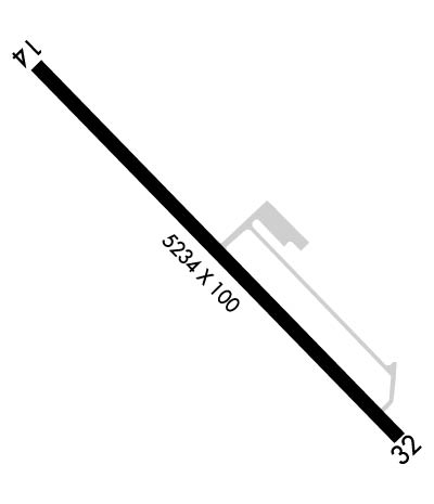
| Lat: N 4628.8 Long: W 08422.1 Elev: 716 Var: +07 Longest Runway: 5234 | ||
| AWOS: 118.37 CTAF: 122.7 | ||
| ||||||
| ||||||
|
| Rwy | Rwy | |||||||
| 5234x100 | 5054' | 5234x100 | 5056' | |||||
| Runway ID | Single Wheel | Double Wheel | Double Tandem Wheel | Dual Double Wheel |
| 14/32 | N/A | N/A | N/A | N/A |
| These numbers are Advisory and are not limits. The Airport Manager should have more accurate Weight Limits | ||||
 Airport Diagram might not be current. | |
| Facility Name: | SAULT STE MARIE MUNI/SANDERSON FLD |
| City Name: | SAULT STE MARIE |
| County: | CHIPPEWA |
| State abbrev: | MI |
| State Name: | MICHIGAN |
| Ownership: | PUBLICLY OWNED |
| Use: | OPEN TO THE PUBLIC |
| Owner's Name: | CITY OF SAULT SAINTE MARIE |
| Address: | 225 E PORTAGE AVE |
| SAULT SAINTE MARIE, MI 49783-2053 | |
| Owner's Phone: | 906-635-5261 |
| Manager's Name: | TOM BROWN |
| Address: | 2144 MERIDIAN ST |
| SAULT SAINTE MARIE, MI 49783-2608 | |
| Phone: | 906-635-0252 |
| FAA Region: | GREAT LAKES |
| FAA Field Office: | DET |
| Date | Sunrise | Sunset |
|---|---|---|
| 09/24/21 Friday | 7:27 | 19:32 |
| 09/25/21 Saturday | 7:28 | 19:30 |
| 09/26/21 Sunday | 7:29 | 19:28 |
| 09/27/21 Monday | 7:30 | 19:26 |
| 09/28/21 Tuesday | 7:32 | 19:24 |
| 09/29/21 Wednesday | 7:33 | 19:22 |
| 09/30/21 Thursday | 7:34 | 19:20 |
| 10/01/21 Friday | 7:36 | 19:18 |
| 10/02/21 Saturday | 7:37 | 19:16 |
| 10/03/21 Sunday | 7:38 | 19:14 |
| 10/04/21 Monday | 7:40 | 19:12 |
| 10/05/21 Tuesday | 7:41 | 19:10 |
| 10/06/21 Wednesday | 7:42 | 19:08 |
| 10/07/21 Thursday | 7:44 | 19:06 |
| Airport Attendance Schedule | 7 Days A Week 0800-1700 |
| Airport Status | OPERATIONAL (This Status can change at any time - please check NOTAMS) |
| Airport Lighting Schedule | ACTVT REIL RWY 14 & 32; PAPI RWY 14 & 32; MIRL RWY 14/32 - CTAF. |
| Airport Storage Available | Tie Downs, Hanger |
| Extra Services Available | Flight Instruction, Aircraft Rental |
| Wind Indicator | YES - (unlit) |
| Control Tower | NO |
| CTAF Frequency | 122.700 |
| Unicom Frequency | 122.700 |
| Rotating Beacon Color | |
| Segmented Circle | YES |
| Landing Fee | NO |
| Airport Inspected | STATE - performed by STATE AERONAUTICAL PERSONNEL |
| Inspection Date | 07/20/2018 |
| Type of Fuel Available | Grade 100LL, JET A (freeze point -40C); -10FUEL AVBL H24 SELF SER VIA CREDIT CARD. |
| Airframe Repair Service | MAJOR |
| Power Plant Repair Service | MAJOR |
| Latitude | N4628.8 |
| Longitude | W08422.1 (ESTIMATED) |
| Arpt Elevation | 716ft (SURVEYED) |
| Magnetic Variation | 07W |
| 1 miles SW | of SAULT STE MARIE |
| Traffic Pattern Altitude | |
| Sectional Chart | LAKE HURON |
| Operations (Reported) | Yearly | Avg. Daily |
|---|---|---|
| General Aviation Transient | 4451 | 12 |
| General Aviation Local | 4616 | 13 |
| Air Taxi | 0 | 0 |
| Commerical | 0 | 0 |
| Commuter | 0 | 0 |
| Military | 0 | 0 |
| Aircraft based on Field | |
|---|---|
| General Aviation Singles | 15 |
| General Aviation Multi | 1 |
| Jet Aircraft | 0 |
| General Aviation Helicopters | 0 |
| Military Aircraft | 0 |
| Gliders | 0 |
| Ultralights | 0 |
| FSS on field | NO |
| FSS tie-in | GREEN BAY |
| FSS Phone | 1-800-WX-BRIEF |
| Who issues Notams | ANJ |
| Notam D service at airport | YES |
| ARTCC Name | MINNEAPOLIS |
| Airport Certification | |
| Aircraft Rescue & Firefighting Index | None |
| Airport of Entry | YES |
| Custom Landing Rights | YES |
| Joint Civil/Military | No |
| Military Landing rights | No |
| US CUSTOMS AVBL ON REQ CALL 906-632-2631 1 HR PRIOR TO ARR. |
| DEER & BIRDS ON & INVOF ARPT. |
| PILOTS OPRG IN CANADIAN/US CLASS D ASP ARE RQRD TO ESTAB & MNTN TWO-WAY COM & OBTAIN ATC CLNC FM SAULT STE MARIE ATCT (SOO TWR 118.8) PRIOR TO OPRG IN THE CLASS D ASP. TFC ADZY SER (118.8) IS AVBL IN THE US CLASS E SFC EXTN 0630-2230. |
| 50 FT DROP OFF, N END, 200 FT FR RWY END. |
| FOR CD CTC MINNEAPOLIS ARTCC AT 651-463-5588. |
| TYPE 1 DEICING AVBL. |
Airport Communications & Frequencies:
| |||||||||
| Runway: 14 | Runway: 32 | ||
| Mag heading: | 143° | Mag heading: | 323° |
| Rwy Slope: | .38% Up | Rwy Slope: | -.38% Down |
| Approach: | Approach: | ||
| Pattern: | Left Traffic | Pattern: | Right Traffic |
| Markings: | BASIC | Markings: | BASIC |
| Marking Condition: | FAIR | Marking Condition: | FAIR |
| Arresting Dev: | Arresting Dev: | ||
| Lat & Long: | N4629.1 W08422.5 | Lat. & Long.: | N4628.4 W08421.7 |
| Elev: | 695.9 ft. MSL | Elev: | 715.9 ft. MSL |
| TCH: | 46 ft. AGL | TCH: | 30 ft. AGL |
| Visual Glide Path: | 3.00 degrees | Visual Glide Path: | 3.00 degrees |
| Displaced Threshold: | 180 feet | Displaced Threshold: | 178 feet |
| Touchdown Zone: | YES | Touchdown Zone: | YES |
| Touchdown Elev.: | 712.2 feet | Touchdown Elev.: | 716.4 feet |
| Visual Glide Slope: | 2-Light PAPI on LEFT side of Runway | Visual Glide Slope: | 2-Light PAPI on LEFT side of Runway |
| RVR Equipment: | RVR Equipment: | ||
| RVV Equipment: | NO | RVV Equipment: | NO |
| Approach Lights: | Approach Lights: | ||
| REIL: | YES | REIL: | YES |
| Centerline Lights: | NO | Centerline Lights: | NO |
| Touchdown lights: | NO | Touchdown lights: | NO |
| Runway Category: | Runway with a Non-precision Approach | Runway Category: | Runway with a Non-precision Approach |
| Declared Distances: | Declared Distances: | ||
| Obstructions: | Obstructions: | ROAD | |
| Marked: | Marked: | NOT Marked/Lighted | |
| Clearance slope: | 50:1; APCH RATIO 50:1 TO DTHR. | Clearance slope: | APCH RATIO 34:1 TO DTHR. OVR +20 FT POLE, 680 FT FM DTHR, 50 FT L. |
| Obstruction height: | Obstruction height: | 13 feet AGL | |
| Dist. from runway: | Dist. from runway: | 201 feet | |
| Centerline offset: | Centerline offset: | 200 feet right of centerline | |
| Comments: | +5 FT FENCE; 130 FT DIST. | Comments: | +6 FT FENCE, 201 FT DIST, 126 FT R. |
Thanks for using FltPlan.com
all rights reserved © 1999-2021 by Flight Plan LLC
