
| ANOKA COUNTY-BLAINE MINNEAPOLIS MN |
| |
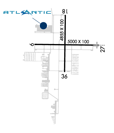
| Lat: N 4508.7 Long: W 09312.6 Elev: 912 Var: -02 Longest Runway: 5000 | ||
| Clr Del: 121.3 Dept. ATIS: 120.62 Arr. ATIS: 120.62 AWOS: 120.62 Ground: 121.85 Tower: 132.4 | ||
| |||||||||||||||||||||||||||||||||||||||||||||||||||||||||||||||||||||
| |||||||||||||||||||||||||||||||||||||||||||||||||||||||||||||||||||||
| |||||||||||||||||||||||||||||||||||||||||||||||||||||||||||||||||||||
| |||||||||||||||||||||||||||||||||||||||||||||||||||||||||||||||||||||
| FBOs at nearby airports who want your business: | |||||||||||
| |||||||||||
| Rwy | Rwy | |||||||
| 5000x100 | 5000' | 5000x100 | 5000' | 111.15 - 268° | ||||
| 4855x100 | 4855' | 4855x100 | 4855' | |||||
| Runway ID | Single Wheel | Double Wheel | Double Tandem Wheel | Dual Double Wheel |
| 09/27 | 23,000 | 60,000 | N/A | N/A |
| 18/36 | 23,000 | 60,000 | N/A | N/A |
| These numbers are Advisory and are not limits. The Airport Manager should have more accurate Weight Limits | ||||
 Airport Diagram might not be current. | |
| Facility Name: | ANOKA COUNTY-BLAINE (JANES FLD) |
| City Name: | MINNEAPOLIS |
| County: | ANOKA |
| State abbrev: | MN |
| State Name: | MINNESOTA |
| Ownership: | PUBLICLY OWNED |
| Use: | OPEN TO THE PUBLIC |
| Owner's Name: | METROPOLITAN AIRPORT CMSN |
| Address: | 6040 28TH AVE. SO. |
| MINNEAPOLIS, MN 55450 | |
| Owner's Phone: | 612-726-8100 |
| Manager's Name: | PHILIP TIEDEMAN |
| Address: | 6040 28TH AVE SO.; EMAIL ADDRESS: PHILIP.TIEDEMAN@MSPMAC.ORG (ALL LOWER CASE) |
| MINNEAPOLIS, MN 55450 | |
| Phone: | 763-717-0001 |
| FAA Region: | GREAT LAKES |
| FAA Field Office: | DMA |

| Date | Sunrise | Sunset |
|---|---|---|
| 09/24/21 Friday | 7:02 | 19:07 |
| 09/25/21 Saturday | 7:03 | 19:05 |
| 09/26/21 Sunday | 7:04 | 19:03 |
| 09/27/21 Monday | 7:06 | 19:01 |
| 09/28/21 Tuesday | 7:07 | 18:59 |
| 09/29/21 Wednesday | 7:08 | 18:57 |
| 09/30/21 Thursday | 7:09 | 18:56 |
| 10/01/21 Friday | 7:11 | 18:54 |
| 10/02/21 Saturday | 7:12 | 18:52 |
| 10/03/21 Sunday | 7:13 | 18:50 |
| 10/04/21 Monday | 7:14 | 18:48 |
| 10/05/21 Tuesday | 7:16 | 18:46 |
| 10/06/21 Wednesday | 7:17 | 18:44 |
| 10/07/21 Thursday | 7:18 | 18:42 |
| Airport Attendance Schedule | CONTINUOUS |
| Airport Status | OPERATIONAL (This Status can change at any time - please check NOTAMS) |
| Airport Lighting Schedule | HIRL RY 09/27 AND MIRL RY 18/36 PRESET ON LOW; INCR INTST AND ACTVT REIL RYS 09; 18; & 36; VASI RYS 18 & 36; PAPI RYS 9 & 27 & MALSR RY 27 - CTAF. |
| Airport Storage Available | Tie Downs, Hanger |
| Extra Services Available | Air Freight, Air Ambulance, Avionics, Charter, Flight Instruction, Aircraft Rental, Aircraft Sales |
| Wind Indicator | YES - (lighted) |
| Control Tower | YES |
| CTAF Frequency | 132.400 |
| Unicom Frequency | 122.950 |
| Rotating Beacon Color | CLEAR-GREEN (Light Land Airport) |
| Segmented Circle | NO |
| Landing Fee | YES; LANDING FEE FOR TURBINE AIRCRAFT |
| Airport Inspected | STATE - performed by STATE AERONAUTICAL PERSONNEL |
| Inspection Date | 10/12/2018 |
| Type of Fuel Available | Grade 100LL, JET A (freeze point -40C); -A JET A LANDING FEE, CONTACT FBO.; -10100LL AVBL 24 HRS WITH CREDIT CARD AT LYNX S RAMP, JET A AVBL AT FBOS. |
| Airframe Repair Service | MAJOR |
| Power Plant Repair Service | MAJOR |
| Latitude | N4508.7 |
| Longitude | W09312.6 (ESTIMATED) |
| Arpt Elevation | 912ft (SURVEYED) |
| Magnetic Variation | 02E |
| 10 miles N | of MINNEAPOLIS |
| Traffic Pattern Altitude | |
| Sectional Chart | TWIN CITIES |
| Operations (Reported) | Yearly | Avg. Daily |
|---|---|---|
| General Aviation Transient | 36189 | 99 |
| General Aviation Local | 28751 | 79 |
| Air Taxi | 4606 | 13 |
| Commerical | 0 | 0 |
| Commuter | 0 | 0 |
| Military | 656 | 2 |
| Aircraft based on Field | |
|---|---|
| General Aviation Singles | 266 |
| General Aviation Multi | 30 |
| Jet Aircraft | 17 |
| General Aviation Helicopters | 6 |
| Military Aircraft | 0 |
| Gliders | 0 |
| Ultralights | 0 |
| FSS on field | NO |
| FSS tie-in | PRINCETON |
| FSS Phone | 1-800-WX-BRIEF |
| Who issues Notams | ANE |
| Notam D service at airport | YES |
| ARTCC Name | MINNEAPOLIS |
| Airport Certification | |
| Aircraft Rescue & Firefighting Index | None |
| Airport of Entry | No |
| Custom Landing Rights | No |
| Joint Civil/Military | No |
| Military Landing rights | YES |
| NATIONAL PLAN OF INTEGRATED AIRPORT SYSTEMS (NPIAS) |
| GRANT AGREEMENTS UNDER FAAP/ADAP/AIP |
| ASSURANCES PURSUANT TO TITLE VI, CIVIL RIGHTS ACT OF 1964 |
| DEER, BIRDS & WILDLIFE ON & INVOF ARPT. |
| FOR NOISE ABATEMENT PROCEDURES, WWW.MACNOISE.COM/PILOTS. ACFT PLEASE FOLLOW VOLUNTARY NOISE ABATEMENT PROCEDURES. |
| WHEN ATCT CLSD SNOW REMOVAL OPERATORS MONITOR 132.4. |
| FOR CD IF UNA TO CTC ON FSS FREQ, CTC MINNEAPOLIS ARTCC AT 651-463-5588. |
| RWY 27 CALM WND RWY WHEN ATCT CLSD. |
Airport Communications & Frequencies:
| |||||||||||||||||||||||||||||
| Runway: 09 | Runway: 27 | ||
| Mag heading: | 89° | Mag heading: | 269° |
| Rwy Slope: | .08% Up | Rwy Slope: | -.08% Down |
| Approach: | Approach: | ILS/DME | |
| Pattern: | Left Traffic | Pattern: | Right Traffic |
| Markings: | NONPRECISION INSTRUMENT | Markings: | PRECISION INSTRUMENT |
| Marking Condition: | GOOD | Marking Condition: | GOOD |
| Arresting Dev: | Arresting Dev: | ||
| Lat & Long: | N4508.7 W09313.2 | Lat. & Long.: | N4508.7 W09312.0 |
| Elev: | 905.1 ft. MSL | Elev: | 908.9 ft. MSL |
| TCH: | 25 ft. AGL | TCH: | 50 ft. AGL |
| Visual Glide Path: | 3.00 degrees | Visual Glide Path: | 3.00 degrees |
| Displaced Threshold: | No | Displaced Threshold: | No |
| Touchdown Zone: | YES | Touchdown Zone: | YES |
| Touchdown Elev.: | 909.8 feet | Touchdown Elev.: | 910.3 feet |
| Visual Glide Slope: | 4-Light PAPI on LEFT side of Runway | Visual Glide Slope: | 4-Light PAPI on LEFT side of Runway |
| RVR Equipment: | RVR Equipment: | ||
| RVV Equipment: | NO | RVV Equipment: | NO |
| Approach Lights: | Approach Lights: | MALSR - 1,400 foot medium intensity approach lighting system with runway alignment indicator lights | |
| REIL: | YES | REIL: | NO |
| Centerline Lights: | NO | Centerline Lights: | NO |
| Touchdown lights: | NO | Touchdown lights: | NO |
| Runway Category: | Runway with a Non-precision Approach having visibility minimums greater than 3/4 mile | Runway Category: | Precision Instrument Runway |
| Declared Distances: | Declared Distances: |
| Runway: 18 | Runway: 36 | ||
| Mag heading: | 179° | Mag heading: | 359° |
| Rwy Slope: | -.06% Down | Rwy Slope: | .06% Up |
| Approach: | Approach: | ||
| Pattern: | Right Traffic | Pattern: | Left Traffic |
| Markings: | NONPRECISION INSTRUMENT | Markings: | NONPRECISION INSTRUMENT |
| Marking Condition: | GOOD | Marking Condition: | GOOD |
| Arresting Dev: | Arresting Dev: | ||
| Lat & Long: | N4509.1 W09312.6 | Lat. & Long.: | N4508.3 W09312.6 |
| Elev: | 912.2 ft. MSL | Elev: | 909.5 ft. MSL |
| TCH: | 51 ft. AGL | TCH: | 50 ft. AGL |
| Visual Glide Path: | 3.00 degrees | Visual Glide Path: | 3.00 degrees |
| Displaced Threshold: | No | Displaced Threshold: | No |
| Touchdown Zone: | YES | Touchdown Zone: | YES |
| Touchdown Elev.: | 912.2 feet | Touchdown Elev.: | 909.8 feet |
| Visual Glide Slope: | 4-BOX VASI ON LEFT SIDE OF RUNWAY | Visual Glide Slope: | 4-BOX VASI ON LEFT SIDE OF RUNWAY |
| RVR Equipment: | RVR Equipment: | ||
| RVV Equipment: | NO | RVV Equipment: | NO |
| Approach Lights: | Approach Lights: | ||
| REIL: | YES | REIL: | YES |
| Centerline Lights: | NO | Centerline Lights: | NO |
| Touchdown lights: | NO | Touchdown lights: | NO |
| Runway Category: | Runway with a Non-precision Approach having visibility minimums greater than 3/4 mile | Runway Category: | Runway with a Visual Approach |
| Declared Distances: | Declared Distances: |
Thanks for using FltPlan.com
all rights reserved © 1999-2021 by Flight Plan LLC


