
| AMES MUNI AMES IA |
| |
| Lat: N 4159.5 Long: W 09337.3 Elev: 956 Var: -03 Longest Runway: 5701 | ||
| Clr Del: 126.0 AWOS: 132.02 CTAF: 122.7 | ||
| ||||||||||||||||||||||||||||||||||||||||||||||||||||||||||||||||||||
| ||||||||||||||||||||||||||||||||||||||||||||||||||||||||||||||||||||
| ||||||||||||||||||||||||||||||||||||||||||||||||||||||||||||||||||||
| ||||||||||||||||||||||||||||||||||||||||||||||||||||||||||||||||||||
| Rwy | Rwy | |||||||
| 5701x100 | 5701' | 110.70 - 013° | 5701x100 | 5701' | ||||
| 3491x75 | 3491' | 3491x75 | 3491' | |||||
| Runway ID | Single Wheel | Double Wheel | Double Tandem Wheel | Dual Double Wheel |
| 01/19 | 30,000 | 38,000 | N/A | N/A |
| 13/31 | 30,000 | N/A | N/A | N/A |
| These numbers are Advisory and are not limits. The Airport Manager should have more accurate Weight Limits | ||||
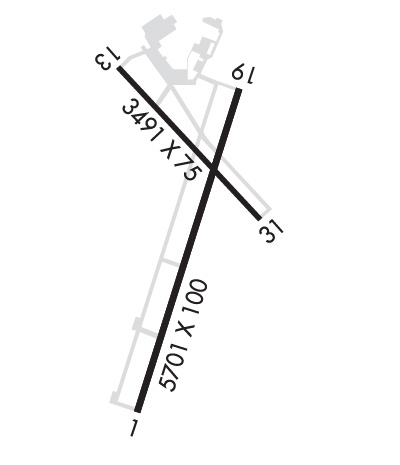 Airport Diagram might not be current. | |
| Facility Name: | AMES MUNI |
| City Name: | AMES |
| County: | STORY |
| State abbrev: | IA |
| State Name: | IOWA |
| Ownership: | PUBLICLY OWNED |
| Use: | OPEN TO THE PUBLIC |
| Owner's Name: | CITY OF AMES |
| Address: | 515 CLARK AVE |
| AMES, IA 50010 | |
| Owner's Phone: | 515-239-5160 |
| Manager's Name: | DAMION PREGITZER |
| Address: | 515 CLARK AVE |
| AMES, IA 50010 | |
| Phone: | 515-239-5275 |
| FAA Region: | CENTRAL |
| FAA Field Office: | NONE |
| Date | Sunrise | Sunset |
|---|---|---|
| 06/08/26 Monday | 5:39 | 20:48 |
| 06/09/26 Tuesday | 5:39 | 20:49 |
| 06/10/26 Wednesday | 5:39 | 20:49 |
| 06/11/26 Thursday | 5:38 | 20:50 |
| 06/12/26 Friday | 5:38 | 20:50 |
| 06/13/26 Saturday | 5:38 | 20:51 |
| 06/14/26 Sunday | 5:38 | 20:51 |
| 06/15/26 Monday | 5:38 | 20:52 |
| 06/16/26 Tuesday | 5:38 | 20:52 |
| 06/17/26 Wednesday | 5:38 | 20:52 |
| 06/18/26 Thursday | 5:38 | 20:53 |
| 06/19/26 Friday | 5:39 | 20:53 |
| 06/20/26 Saturday | 5:39 | 20:53 |
| 06/21/26 Sunday | 5:39 | 20:54 |
| Airport Attendance Schedule | 7 Days A Week DAWN-DUSK |
| Airport Status | OPERATIONAL (This Status can change at any time - please check NOTAMS) |
| Airport Lighting Schedule | ACTVT MALSR RWY 01; VASI RWYS 19; HIRL RWY 01/19 & MIRL RWY 13/31 - CTAF. |
| Airport Storage Available | Tie Downs, Hanger |
| Extra Services Available | Charter, Flight Instruction, Aircraft Rental, Aircraft Sales |
| Wind Indicator | YES - (lighted) |
| Control Tower | NO |
| CTAF Frequency | 122.700 |
| Unicom Frequency | 122.700 |
| Rotating Beacon Color | WG |
| Segmented Circle | YES |
| Landing Fee | NO |
| Airport Inspected | STATE - performed by STATE AERONAUTICAL PERSONNEL |
| Inspection Date | 09/12/2022 |
| Type of Fuel Available | Grade 100, JET A (freeze point -40C) |
| Airframe Repair Service | MAJOR |
| Power Plant Repair Service | MAJOR |
| Latitude | N4159.5 |
| Longitude | W09337.3 (ESTIMATED) |
| Arpt Elevation | 955ft (SURVEYED) |
| Magnetic Variation | 03E |
| 2 miles SE | of AMES |
| Traffic Pattern Altitude | |
| Sectional Chart | OMAHA |
| Operations (Reported) | Yearly | Avg. Daily |
|---|---|---|
| General Aviation Transient | 0 | 0 |
| General Aviation Local | 0 | 0 |
| Air Taxi | 0 | 0 |
| Commerical | 0 | 0 |
| Commuter | 0 | 0 |
| Military | 0 | 0 |
| Aircraft based on Field | |
|---|---|
| General Aviation Singles | 0 |
| General Aviation Multi | 0 |
| Jet Aircraft | 0 |
| General Aviation Helicopters | 0 |
| Military Aircraft | 0 |
| Gliders | 0 |
| Ultralights | 0 |
| FSS on field | NO |
| FSS tie-in | FORT DODGE |
| FSS Phone | 1-800-WX-BRIEF |
| Who issues Notams | AMW |
| Notam D service at airport | YES |
| ARTCC Name | MINNEAPOLIS |
| Airport Certification | |
| Aircraft Rescue & Firefighting Index | None |
| Airport of Entry | No |
| Custom Landing Rights | No |
| Joint Civil/Military | No |
| Military Landing rights | YES |
| NATIONAL PLAN OF INTEGRATED AIRPORT SYSTEMS (NPIAS) |
| GRANT AGREEMENTS UNDER FAAP/ADAP/AIP |
| ASSURANCES PURSUANT TO TITLE VI, CIVIL RIGHTS ACT OF 1964 |
| BE ALERT FOR GLIDER & ULTRALIGHT OPNS INVOF ARPT. |
| BIRD AND DEER ACT ON & INVOF ARPT |
| RWY 01 IS CALM WIND RWY. |
| STADIUM WI 3 NM, CHECK FOR EVENTS. |
| COLD TEMPERATURE AIRPORT. ALTITUDE CORRECTION REQUIRED AT OR BELOW -26C. |
| FOR CD CTC DES MOINES ATCT ON 126.0 OR CALL 515-974- 8016. |
Airport Communications & Frequencies:
| ||||||||||||||||
| Runway: 01 | Runway: 19 | ||
| Mag heading: | 14° | Mag heading: | 194° |
| Rwy Slope: | -.64% Down | Rwy Slope: | .64% Up |
| Approach: | ILS/DME | Approach: | |
| Pattern: | Right Traffic | Pattern: | Left Traffic |
| Markings: | PRECISION INSTRUMENT | Markings: | NONPRECISION INSTRUMENT |
| Marking Condition: | GOOD | Marking Condition: | GOOD |
| Arresting Dev: | Arresting Dev: | ||
| Lat & Long: | N4159.0 W09337.5 | Lat. & Long.: | N4159.9 W09337.1 |
| Elev: | 955.6 ft. MSL | Elev: | 919.0 ft. MSL |
| TCH: | TCH: | 41 ft. AGL | |
| Visual Glide Path: | Visual Glide Path: | 4.00 degrees | |
| Displaced Threshold: | No | Displaced Threshold: | No |
| Touchdown Zone: | YES | Touchdown Zone: | YES |
| Touchdown Elev.: | 955.6 feet | Touchdown Elev.: | 937.4 feet |
| Visual Glide Slope: | Visual Glide Slope: | 4-BOX VASI ON LEFT SIDE OF RUNWAY | |
| RVR Equipment: | RVR Equipment: | ||
| RVV Equipment: | NO | RVV Equipment: | NO |
| Approach Lights: | MALSR - 1,400 foot medium intensity approach lighting system with runway alignment indicator lights | Approach Lights: | |
| REIL: | NO | REIL: | NO |
| Centerline Lights: | NO | Centerline Lights: | NO |
| Touchdown lights: | NO | Touchdown lights: | NO |
| Runway Category: | Precision Instrument Runway | Runway Category: | Runway with a Non-precision Approach having visibility minimums greater than 3/4 mile |
| Declared Distances: | Declared Distances: | ||
| Obstructions: | TREE | Obstructions: | TREE |
| Marked: | NOT Marked/Lighted | Marked: | NOT Marked/Lighted |
| Clearance slope: | 27:1 | Clearance slope: | 25:1 |
| Obstruction height: | 78 feet AGL | Obstruction height: | 87 feet AGL |
| Dist. from runway: | 2380 feet | Dist. from runway: | 2400 feet |
| Centerline offset: | 350 left of centerline | Centerline offset: | 345 feet left of centerline |
| Comments: | Comments: |
| Runway: 13 | Runway: 31 | ||
| Mag heading: | 133° | Mag heading: | 313° |
| Rwy Slope: | -.16% Down | Rwy Slope: | .16% Up |
| Approach: | Approach: | ||
| Pattern: | Right Traffic | Pattern: | Left Traffic |
| Markings: | NONPRECISION INSTRUMENT | Markings: | NONPRECISION INSTRUMENT |
| Marking Condition: | GOOD | Marking Condition: | GOOD |
| Arresting Dev: | Arresting Dev: | ||
| Lat & Long: | N4159.9 W09337.6 | Lat. & Long.: | N4159.5 W09337.0 |
| Elev: | 925.9 ft. MSL | Elev: | 920.2 ft. MSL |
| TCH: | TCH: | ||
| Visual Glide Path: | Visual Glide Path: | ||
| Displaced Threshold: | No | Displaced Threshold: | No |
| Touchdown Zone: | YES | Touchdown Zone: | YES |
| Touchdown Elev.: | 929.3 feet | Touchdown Elev.: | 929.3 feet |
| Visual Glide Slope: | Visual Glide Slope: | ||
| RVR Equipment: | RVR Equipment: | ||
| RVV Equipment: | NO | RVV Equipment: | NO |
| Approach Lights: | Approach Lights: | ||
| REIL: | NO | REIL: | NO |
| Centerline Lights: | NO | Centerline Lights: | NO |
| Touchdown lights: | NO | Touchdown lights: | NO |
| Runway Category: | Runway with a Non-precision Approach having visibility minimums greater than 3/4 mile | Runway Category: | Runway with a Non-precision Approach having visibility minimums greater than 3/4 mile |
| Declared Distances: | Declared Distances: | ||
| Obstructions: | TREE | Obstructions: | TREE |
| Marked: | NOT Marked/Lighted | Marked: | NOT Marked/Lighted |
| Clearance slope: | 7:1 | Clearance slope: | 16:1 |
| Obstruction height: | 16 feet AGL | Obstruction height: | 50 feet AGL |
| Dist. from runway: | 320 feet | Dist. from runway: | 1011 feet |
| Centerline offset: | 164 left of centerline | Centerline offset: | 70 feet right of centerline |
| Comments: | 32 FT TREE 124 FT FM RWY END AND 158 FT R ON APCH; CLNC SLOPE 1:1 | Comments: |
Thanks for using FltPlan.com
all rights reserved © 1999-2026 by Flight Plan LLC


