
| GRATIOT COMMUNITY AIRPORT ALMA MI |
| |
| Lat: N 4319.3 Long: W 08441.3 Elev: 754 Var: +05 Longest Runway: 5004 | ||
| Clr Del: 119.25 AWOS: 124.17 CTAF: 122.8 | ||
| ||||||
| ||||||
|
| Rwy | Rwy | |||||||
| 5004x75 | 5004' | 108.90 - 095° | 5004x75 | 5004' | ||||
| 3198x75 | 3198' | 3198x75 | 3198' | |||||
| Runway ID | Single Wheel | Double Wheel | Double Tandem Wheel | Dual Double Wheel |
| 09/27 | 40,000 | 65,000 | N/A | N/A |
| 18/36 | 26,000 | N/A | N/A | N/A |
| These numbers are Advisory and are not limits. The Airport Manager should have more accurate Weight Limits | ||||
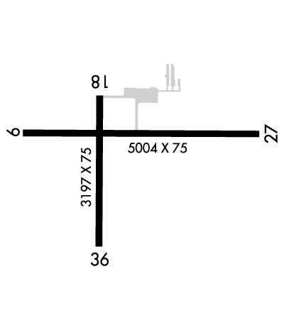 Airport Diagram might not be current. | |
| Facility Name: | GRATIOT COMMUNITY |
| City Name: | ALMA |
| County: | GRATIOT |
| State abbrev: | MI |
| State Name: | MICHIGAN |
| Ownership: | PUBLICLY OWNED |
| Use: | OPEN TO THE PUBLIC |
| Owner's Name: | CITY OF ALMA/CO OF GRATIOT |
| Address: | 525 E SUPERIOR ST, PO BOX 278 |
| ALMA, MI 48801 | |
| Owner's Phone: | 989-463-8336 |
| Manager's Name: | SCOTT MCDONALD |
| Address: | 3999 W SEAMAN RD |
| ALMA, MI 48801-9232 | |
| Phone: | 989-463-5500 |
| FAA Region: | GREAT LAKES |
| FAA Field Office: | DET |
| Date | Sunrise | Sunset |
|---|---|---|
| 06/07/26 Sunday | 5:59 | 21:16 |
| 06/08/26 Monday | 5:59 | 21:17 |
| 06/09/26 Tuesday | 5:58 | 21:18 |
| 06/10/26 Wednesday | 5:58 | 21:18 |
| 06/11/26 Thursday | 5:58 | 21:19 |
| 06/12/26 Friday | 5:58 | 21:19 |
| 06/13/26 Saturday | 5:58 | 21:20 |
| 06/14/26 Sunday | 5:58 | 21:20 |
| 06/15/26 Monday | 5:58 | 21:21 |
| 06/16/26 Tuesday | 5:58 | 21:21 |
| 06/17/26 Wednesday | 5:58 | 21:21 |
| 06/18/26 Thursday | 5:58 | 21:22 |
| 06/19/26 Friday | 5:58 | 21:22 |
| 06/20/26 Saturday | 5:58 | 21:22 |
| Airport Attendance Schedule | MON-SAT 0830-1430 |
| Airport Status | OPERATIONAL (This Status can change at any time - please check NOTAMS) |
| Airport Lighting Schedule | ACTVT REIL RWY 09 & 27; PAPI RWY 09 & 27; MIRL RWY 09/27 & 18/36 - CTAF. |
| Airport Storage Available | Tie Downs, Hanger |
| Extra Services Available | Flight Instruction, Aircraft Rental |
| Wind Indicator | YES - (lighted) |
| Control Tower | NO |
| CTAF Frequency | 122.800 |
| Unicom Frequency | 122.800 |
| Rotating Beacon Color | WG |
| Segmented Circle | YES |
| Landing Fee | NO |
| Airport Inspected | STATE - performed by STATE AERONAUTICAL PERSONNEL |
| Inspection Date | 10/02/2023 |
| Type of Fuel Available | Grade 100LL, JET A |
| Airframe Repair Service | NONE |
| Power Plant Repair Service | NONE |
| Latitude | N4319.3 |
| Longitude | W08441.3 (ESTIMATED) |
| Arpt Elevation | 754ft (SURVEYED) |
| Magnetic Variation | 05W |
| 3 miles SW | of ALMA |
| Traffic Pattern Altitude | |
| Sectional Chart | DETROIT |
| Operations (Reported) | Yearly | Avg. Daily |
|---|---|---|
| General Aviation Transient | 0 | 0 |
| General Aviation Local | 0 | 0 |
| Air Taxi | 0 | 0 |
| Commerical | 0 | 0 |
| Commuter | 0 | 0 |
| Military | 0 | 0 |
| Aircraft based on Field | |
|---|---|
| General Aviation Singles | 0 |
| General Aviation Multi | 0 |
| Jet Aircraft | 0 |
| General Aviation Helicopters | 0 |
| Military Aircraft | 0 |
| Gliders | 0 |
| Ultralights | 0 |
| FSS on field | NO |
| FSS tie-in | LANSING |
| FSS Phone | 1-800-WX-BRIEF |
| Who issues Notams | AMN |
| Notam D service at airport | YES |
| ARTCC Name | CLEVELAND |
| Airport Certification | |
| Aircraft Rescue & Firefighting Index | None |
| Airport of Entry | No |
| Custom Landing Rights | No |
| Joint Civil/Military | No |
| Military Landing rights | YES |
| NATIONAL PLAN OF INTEGRATED AIRPORT SYSTEMS (NPIAS) |
| GRANT AGREEMENTS UNDER FAAP/ADAP/AIP |
| ASSURANCES PURSUANT TO TITLE VI, CIVIL RIGHTS ACT OF 1964 |
| DEER & LRG BIRDS ON & INVOF ARPT. |
| ADMIN BLDG ACES, PRESS V, THEN III & II SIMUL, THEN I. |
| FOR CD CTC GREAT LAKES APCH AT 269-459-3345, WHEN APCH CLSD CTC CLEVELAND ARTCC AT 440-774-0224/0490. |
Airport Communications & Frequencies:
| |||||||||||||||||
| Runway: 09 | Runway: 27 | ||
| Mag heading: | 95° | Mag heading: | 275° |
| Rwy Slope: | .05% Up | Rwy Slope: | -.05% Down |
| Approach: | SDF | Approach: | |
| Pattern: | Left Traffic | Pattern: | Left Traffic |
| Markings: | NONPRECISION INSTRUMENT | Markings: | NONPRECISION INSTRUMENT |
| Marking Condition: | FAIR | Marking Condition: | FAIR |
| Arresting Dev: | Arresting Dev: | ||
| Lat & Long: | N4319.4 W08441.8 | Lat. & Long.: | N4319.4 W08440.6 |
| Elev: | 750.5 ft. MSL | Elev: | 753.2 ft. MSL |
| TCH: | 40 ft. AGL | TCH: | 40 ft. AGL |
| Visual Glide Path: | 3.00 degrees | Visual Glide Path: | 3.00 degrees |
| Displaced Threshold: | No | Displaced Threshold: | No |
| Touchdown Zone: | YES | Touchdown Zone: | YES |
| Touchdown Elev.: | 753.5 feet | Touchdown Elev.: | 753.5 feet |
| Visual Glide Slope: | 4-Light PAPI on LEFT side of Runway | Visual Glide Slope: | 4-Light PAPI on LEFT side of Runway |
| RVR Equipment: | RVR Equipment: | ||
| RVV Equipment: | NO | RVV Equipment: | NO |
| Approach Lights: | Approach Lights: | ||
| REIL: | YES | REIL: | YES |
| Centerline Lights: | NO | Centerline Lights: | NO |
| Touchdown lights: | NO | Touchdown lights: | NO |
| Runway Category: | Runway with a Non-precision Approach having visibility minimums greater than 3/4 mile | Runway Category: | Runway with a Non-precision Approach having visibility minimums greater than 3/4 mile |
| Declared Distances: | Declared Distances: | ||
| Obstructions: | TREE | Obstructions: | |
| Marked: | NOT Marked/Lighted | Marked: | |
| Clearance slope: | 26:1 | Clearance slope: | 34:1 |
| Obstruction height: | 79 feet AGL | Obstruction height: | |
| Dist. from runway: | 2307 feet | Dist. from runway: | |
| Centerline offset: | 266 left of centerline | Centerline offset: | |
| Comments: | Comments: |
| Runway: 18 | Runway: 36 | ||
| Mag heading: | 185° | Mag heading: | 5° |
| Rwy Slope: | .03% Up | Rwy Slope: | -.03% Down |
| Approach: | Approach: | ||
| Pattern: | Left Traffic | Pattern: | Left Traffic |
| Markings: | NONPRECISION INSTRUMENT | Markings: | NONPRECISION INSTRUMENT |
| Marking Condition: | FAIR | Marking Condition: | FAIR |
| Arresting Dev: | Arresting Dev: | ||
| Lat & Long: | N4319.5 W08441.4 | Lat. & Long.: | N4319.0 W08441.4 |
| Elev: | 753.2 ft. MSL | Elev: | 754.0 ft. MSL |
| TCH: | TCH: | ||
| Visual Glide Path: | Visual Glide Path: | ||
| Displaced Threshold: | No | Displaced Threshold: | No |
| Touchdown Zone: | YES | Touchdown Zone: | YES |
| Touchdown Elev.: | 753.9 feet | Touchdown Elev.: | 754.1 feet |
| Visual Glide Slope: | Visual Glide Slope: | ||
| RVR Equipment: | RVR Equipment: | ||
| RVV Equipment: | NO | RVV Equipment: | NO |
| Approach Lights: | Approach Lights: | ||
| REIL: | NO | REIL: | NO |
| Centerline Lights: | NO | Centerline Lights: | NO |
| Touchdown lights: | NO | Touchdown lights: | NO |
| Runway Category: | Runway with a Non-precision Approach having visibility minimums greater than 3/4 mile | Runway Category: | Runway with a Visual Approach |
| Declared Distances: | Declared Distances: | ||
| Obstructions: | TREE | Obstructions: | |
| Marked: | NOT Marked/Lighted | Marked: | |
| Clearance slope: | 16:1 | Clearance slope: | 20:1 |
| Obstruction height: | 56 feet AGL | Obstruction height: | |
| Dist. from runway: | 1119 feet | Dist. from runway: | |
| Centerline offset: | 383 left of centerline | Centerline offset: | |
| Comments: | Comments: |
Thanks for using FltPlan.com
all rights reserved © 1999-2026 by Flight Plan LLC
