
| THOMAS C RUSSELL FLD ALEXANDER CITY AL |
| |
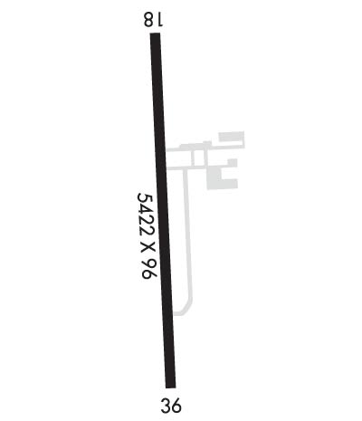
| Lat: N 3254.9 Long: W 08557.8 Elev: 686 Var: +04 Longest Runway: 5422 | ||
| AWOS: 118.32 CTAF: 122.7 | ||
| ||||||
| ||||||
|
| Rwy | Rwy | |||||||
| 5422x96 | 4799' | 5422x96 | 5422' | |||||
| Runway ID | Single Wheel | Double Wheel | Double Tandem Wheel | Dual Double Wheel |
| 18/36 | 30,000 | N/A | N/A | N/A |
| These numbers are Advisory and are not limits. The Airport Manager should have more accurate Weight Limits | ||||
 Airport Diagram might not be current. | |
| Facility Name: | THOMAS C RUSSELL FLD |
| City Name: | ALEXANDER CITY |
| County: | TALLAPOOSA |
| State abbrev: | AL |
| State Name: | ALABAMA |
| Ownership: | PUBLICLY OWNED |
| Use: | OPEN TO THE PUBLIC |
| Owner's Name: | CITY OF ALEXANDER CITY |
| Address: | PO BOX 552 |
| ALEXANDER CITY, AL 35011 | |
| Owner's Phone: | (256) 329-9057 |
| Manager's Name: | MIKE SMITH |
| Address: | 997 T.C. RUSSELL FIELD |
| ALEXANDER CITY, AL 35010 | |
| Phone: | 256-329-9057; ON CALL 256-392-2452. |
| FAA Region: | SOUTHERN |
| FAA Field Office: | JAN |

| Date | Sunrise | Sunset |
|---|---|---|
| 09/24/21 Friday | 6:33 | 18:38 |
| 09/25/21 Saturday | 6:34 | 18:37 |
| 09/26/21 Sunday | 6:34 | 18:35 |
| 09/27/21 Monday | 6:35 | 18:34 |
| 09/28/21 Tuesday | 6:36 | 18:33 |
| 09/29/21 Wednesday | 6:36 | 18:31 |
| 09/30/21 Thursday | 6:37 | 18:30 |
| 10/01/21 Friday | 6:38 | 18:29 |
| 10/02/21 Saturday | 6:39 | 18:27 |
| 10/03/21 Sunday | 6:39 | 18:26 |
| 10/04/21 Monday | 6:40 | 18:25 |
| 10/05/21 Tuesday | 6:41 | 18:23 |
| 10/06/21 Wednesday | 6:41 | 18:22 |
| 10/07/21 Thursday | 6:42 | 18:21 |
| Airport Attendance Schedule | MON-FRI 0800-1700 |
| Airport Status | OPERATIONAL (This Status can change at any time - please check NOTAMS) |
| Airport Lighting Schedule | ACTVT REIL RWY 36; MIRL RWY 18/36 - CTAF. |
| Airport Storage Available | Tie Downs |
| Extra Services Available | NONE |
| Wind Indicator | YES - (lighted) |
| Control Tower | NO |
| CTAF Frequency | 122.700 |
| Unicom Frequency | 122.700 |
| Rotating Beacon Color | CLEAR-GREEN (Light Land Airport) |
| Segmented Circle | YES |
| Landing Fee | NO |
| Airport Inspected | STATE - performed by STATE AERONAUTICAL PERSONNEL |
| Inspection Date | 10/05/2018 |
| Type of Fuel Available | Grade 100LL, JET A (freeze point -40C); -1024 HR CREDIT CARD SVC AVGAS ONLY AVBL. |
| Airframe Repair Service | MAJOR |
| Power Plant Repair Service | MAJOR |
| Latitude | N3254.9 |
| Longitude | W08557.8 (ESTIMATED) |
| Arpt Elevation | 685ft (SURVEYED) |
| Magnetic Variation | 04W |
| 2 miles SW | of ALEXANDER CITY |
| Traffic Pattern Altitude | |
| Sectional Chart | ATLANTA |
| Operations (Reported) | Yearly | Avg. Daily |
|---|---|---|
| General Aviation Transient | 26280 | 72 |
| General Aviation Local | 4032 | 11 |
| Air Taxi | 0 | 0 |
| Commerical | 0 | 0 |
| Commuter | 0 | 0 |
| Military | 3000 | 8 |
| Aircraft based on Field | |
|---|---|
| General Aviation Singles | 22 |
| General Aviation Multi | 6 |
| Jet Aircraft | 1 |
| General Aviation Helicopters | 0 |
| Military Aircraft | 0 |
| Gliders | 0 |
| Ultralights | 0 |
| FSS on field | NO |
| FSS tie-in | ANNISTON |
| FSS Phone | 1-800-WX-BRIEF |
| Who issues Notams | ALX |
| Notam D service at airport | YES |
| ARTCC Name | ATLANTA |
| Airport Certification | |
| Aircraft Rescue & Firefighting Index | None |
| Airport of Entry | No |
| Custom Landing Rights | No |
| Joint Civil/Military | No |
| Military Landing rights | YES |
| NATIONAL PLAN OF INTEGRATED AIRPORT SYSTEMS (NPIAS) |
| GRANT AGREEMENTS UNDER FAAP/ADAP/AIP |
| ASSURANCES PURSUANT TO TITLE VI, CIVIL RIGHTS ACT OF 1964 |
| TWY LGTS FOR TWY TURNOFF ONLY. |
| FOR CD CTC MONTGOMERY APCH AT 334-284-4575. WHEN APCH CLSD FOR CD CTC ATLANTA ARTCC AT 770-210-7692. |
Airport Communications & Frequencies:
| |||||||||||||||||
| Runway: 18 | Runway: 36 | ||
| Mag heading: | 182° | Mag heading: | 2° |
| Rwy Slope: | -1.36% Down | Rwy Slope: | 1.36% Up |
| Approach: | Approach: | ||
| Pattern: | Left Traffic | Pattern: | Left Traffic |
| Markings: | NONPRECISION INSTRUMENT | Markings: | NONPRECISION INSTRUMENT |
| Marking Condition: | GOOD | Marking Condition: | GOOD |
| Arresting Dev: | Arresting Dev: | ||
| Lat & Long: | N3255.3 W08557.8 | Lat. & Long.: | N3254.4 W08557.8 |
| Elev: | 685.8 ft. MSL | Elev: | 611.9 ft. MSL |
| TCH: | 57 ft. AGL | TCH: | 50 ft. AGL |
| Visual Glide Path: | 3.00 degrees | Visual Glide Path: | 3.00 degrees |
| Displaced Threshold: | 623 feet | Displaced Threshold: | No |
| Touchdown Zone: | YES | Touchdown Zone: | YES |
| Touchdown Elev.: | 674.9 feet | Touchdown Elev.: | 648.4 feet |
| Visual Glide Slope: | 4-Light PAPI on LEFT side of Runway; PAPI UNUSBL BYD 5 DEG LEFT AND 6 DEG RIGHT OF CNTRLN. | Visual Glide Slope: | 4-Light PAPI on LEFT side of Runway; PAPI UNUSBL BYD 6 DEG LEFT OF CNTRLN. |
| RVR Equipment: | RVR Equipment: | ||
| RVV Equipment: | NO | RVV Equipment: | NO |
| Approach Lights: | Approach Lights: | ||
| REIL: | NO | REIL: | YES |
| Centerline Lights: | NO | Centerline Lights: | NO |
| Touchdown lights: | NO | Touchdown lights: | NO |
| Runway Category: | Runway with a Visual Approach | Runway Category: | Runway with a Non-precision Approach having visibility minimums greater than 3/4 mile |
| Declared Distances: | Declared Distances: | ||
| Obstructions: | TREES | Obstructions: | TREES |
| Marked: | NOT Marked/Lighted | Marked: | NOT Marked/Lighted |
| Clearance slope: | 4:1; APCH RATIO 22:1 FM DSPLCD THR. | Clearance slope: | 13:1 |
| Obstruction height: | 47 feet AGL | Obstruction height: | 24 feet AGL |
| Dist. from runway: | 424 feet | Dist. from runway: | 524 feet |
| Centerline offset: | 111 left of centerline | Centerline offset: | 192 feet right of centerline |
| Comments: | Comments: |
Thanks for using FltPlan.com
all rights reserved © 1999-2021 by Flight Plan LLC