
| WALLA WALLA RGNL WALLA WALLA WA |
| |
| Lat: N 4605.6 Long: W 11817.0 Elev: 1194 Var: -14 Longest Runway: 6527 | ||
| AWOS: 135.87 Ground: 121.6 Tower: 118.5 | ||
| ||||||||||||||||||||||||||||||||||||||||||||
| ||||||||||||||||||||||||||||||||||||||||||||
| ||||||||||||||||||||||||||||||||||||||||||||
| Rwy | Rwy | |||||||
| 6527x150 | 6527' | 6527x150 | 6527' | 111.70 - 196° | ||||
| Runway ID | Single Wheel | Double Wheel | Double Tandem Wheel | Dual Double Wheel |
| 02/20 | 84,000 | 107,000 | 164,000 | N/A |
| These numbers are Advisory and are not limits. The Airport Manager should have more accurate Weight Limits | ||||
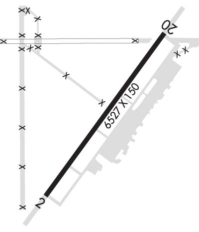 Airport Diagram might not be current. | |
| Facility Name: | WALLA WALLA RGNL |
| City Name: | WALLA WALLA |
| County: | WALLA WALLA |
| State abbrev: | WA |
| State Name: | WASHINGTON |
| Ownership: | PUBLICLY OWNED |
| Use: | OPEN TO THE PUBLIC |
| Owner's Name: | PORT OF WALLA WALLA |
| Address: | 45 TERMINAL LOOP RD., SUITE 210 |
| WALLA WALLA, WA 99362 | |
| Owner's Phone: | 509-525-3100 |
| Manager's Name: | JENNIFER SKOGLUND |
| Address: | 45 TERMINAL LOOP RD., SUITE 210 |
| WALLA WALLA, WA 99362 | |
| Phone: | 509-525-3100 |
| FAA Region: | NORTHWEST MOUNTAIN |
| FAA Field Office: | SEA |

| Date | Sunrise | Sunset |
|---|---|---|
| 06/08/26 Monday | 5:02 | 20:42 |
| 06/09/26 Tuesday | 5:02 | 20:43 |
| 06/10/26 Wednesday | 5:02 | 20:43 |
| 06/11/26 Thursday | 5:02 | 20:44 |
| 06/12/26 Friday | 5:02 | 20:45 |
| 06/13/26 Saturday | 5:01 | 20:45 |
| 06/14/26 Sunday | 5:01 | 20:46 |
| 06/15/26 Monday | 5:01 | 20:46 |
| 06/16/26 Tuesday | 5:01 | 20:46 |
| 06/17/26 Wednesday | 5:01 | 20:47 |
| 06/18/26 Thursday | 5:01 | 20:47 |
| 06/19/26 Friday | 5:01 | 20:47 |
| 06/20/26 Saturday | 5:02 | 20:48 |
| 06/21/26 Sunday | 5:02 | 20:48 |
| Airport Attendance Schedule | 7 Days A Week 0800-1800 |
| Airport Status | OPERATIONAL (This Status can change at any time - please check NOTAMS) |
| Airport Lighting Schedule | WHEN ATCT CLSD ACTVT MALSR RY 20, REIL RY 02 & HIRL RY 02/20 - CTAF. |
| Airport Storage Available | Tie Downs, Hanger |
| Extra Services Available | Air Freight, Crop Dusting, Air Ambulance, Cargo Handling, Charter, Flight Instruction, Aircraft Rental, Aircraft Sales |
| Wind Indicator | YES - (lighted) |
| Control Tower | YES |
| CTAF Frequency | 118.500 |
| Unicom Frequency | 122.950 |
| Rotating Beacon Color | WG |
| Segmented Circle | NO |
| Landing Fee | NO |
| Airport Inspected | FEDERAL - performed by FAA AIRPORTS FIELD PERSONNEL |
| Inspection Date | 06/27/2025 |
| Type of Fuel Available | Grade 100LL, JET A (freeze point -40C); -10SELF SVC CREDIT CARD FUELING FACILITY LCTD 600 FT N OF ATCT. |
| Airframe Repair Service | MAJOR |
| Power Plant Repair Service | MAJOR |
| Latitude | N4605.6 |
| Longitude | W11817.0 (ESTIMATED) |
| Arpt Elevation | 1194ft (SURVEYED) |
| Magnetic Variation | 14E |
| 3 miles NE | of WALLA WALLA |
| Traffic Pattern Altitude | |
| Sectional Chart | SEATTLE |
| Operations (Reported) | Yearly | Avg. Daily |
|---|---|---|
| General Aviation Transient | 0 | 0 |
| General Aviation Local | 0 | 0 |
| Air Taxi | 0 | 0 |
| Commerical | 0 | 0 |
| Commuter | 0 | 0 |
| Military | 0 | 0 |
| Aircraft based on Field | |
|---|---|
| General Aviation Singles | 0 |
| General Aviation Multi | 0 |
| Jet Aircraft | 0 |
| General Aviation Helicopters | 0 |
| Military Aircraft | 0 |
| Gliders | 0 |
| Ultralights | 0 |
| FSS on field | NO |
| FSS tie-in | SEATTLE |
| FSS Phone | 1-800-WX-BRIEF |
| Who issues Notams | ALW |
| Notam D service at airport | YES |
| ARTCC Name | SEATTLE |
| Airport Certification | AIRPORT RECEIVING SCHEDULED AIR CARRIER SERVICE FROM CARRIERS CERTIFICATED BY THE CIVIL AERONAUTICS BOARD; ARFF SVCS AVBL DURING SCHEDULED ACR OPS. CLSD TO UNSKED ACR OPNS WITH MORE THAN 30 PSGR SEATS EXCP PPR CALL AMGR 509-525-3100. |
| Aircraft Rescue & Firefighting Index | AIRPORT HAS A CERTIFICATE UNDER CFR PART 139 |
| Airport of Entry | No |
| Custom Landing Rights | No |
| Joint Civil/Military | No |
| Military Landing rights | YES |
| NATIONAL PLAN OF INTEGRATED AIRPORT SYSTEMS (NPIAS) |
| GRANT AGREEMENTS UNDER FAAP/ADAP/AIP |
| SURPLUS PROPERTY AGREEMENT UNDER PUBLIC LAW 289 |
| AGREEMENT UNDER DLAND OR DCLA HAS EXPIRED. |
| SFC CONDS UNMON 0000-0300. |
| TWY A,A1,A2,A3,A4,A5 OPEN TO AIR CARRIERS. |
| 24 HR FUEL SVC CALL 509-540-1081. |
| PTN OF CORNER AT TWY A & TWY A1 NOT VSB BY TWR. |
| FOR CD WHEN ALW ATC IS CLSD CTC SPOKANE APCH AT 509-742-2525. WHEN APCH CLSD CTC SEATTLE ARTCC AT 253-351-3694 |
| CTC AMGR 509-525-3100 FOR ARNGMT FOR RAMP PRKG OF 175,000 LB MTOW |
| RWY 02/2 0 PCR VALUE: 340/F/D/X/T |
Airport Communications & Frequencies:
| |||||||||||||||||||||||||
| Runway: 02 | Runway: 20 | ||
| Mag heading: | 22° | Mag heading: | 202° |
| Rwy Slope: | .62% Up | Rwy Slope: | -.62% Down |
| Approach: | Approach: | ILS | |
| Pattern: | Left Traffic | Pattern: | Left Traffic |
| Markings: | NONPRECISION INSTRUMENT | Markings: | PRECISION INSTRUMENT |
| Marking Condition: | GOOD | Marking Condition: | GOOD |
| Arresting Dev: | Arresting Dev: | ||
| Lat & Long: | N4605.1 W11817.5 | Lat. & Long.: | N4606.0 W11816.6 |
| Elev: | 1153.9 ft. MSL | Elev: | 1194.4 ft. MSL |
| TCH: | 45 ft. AGL | TCH: | 50 ft. AGL |
| Visual Glide Path: | 3.00 degrees | Visual Glide Path: | 3.00 degrees |
| Displaced Threshold: | No | Displaced Threshold: | No |
| Touchdown Zone: | YES | Touchdown Zone: | YES |
| Touchdown Elev.: | 1175.0 feet | Touchdown Elev.: | 1194.4 feet |
| Visual Glide Slope: | 4-Light PAPI on LEFT side of Runway | Visual Glide Slope: | 4-Light PAPI on LEFT side of Runway |
| RVR Equipment: | ROLLOUT | RVR Equipment: | TOUCHDOWN |
| RVV Equipment: | NO | RVV Equipment: | NO |
| Approach Lights: | Approach Lights: | MALSR - 1,400 foot medium intensity approach lighting system with runway alignment indicator lights | |
| REIL: | YES | REIL: | NO |
| Centerline Lights: | NO | Centerline Lights: | NO |
| Touchdown lights: | NO | Touchdown lights: | NO |
| Runway Category: | Runway with a Non-precision Approach having visibility minimums greater than 3/4 mile | Runway Category: | Precision Instrument Runway |
| Declared Distances: | TORA:6527' TODA:6527' ASDA:6527' LDA:6527' | Declared Distances: | TORA:6527' TODA:6527' ASDA:6527' LDA:6527' |
| Obstructions: | Unknown | Obstructions: | |
| Marked: | NOT Marked/Lighted | Marked: | |
| Clearance slope: | 50:1 | Clearance slope: | 50:1 |
| Obstruction height: | 0 feet AGL | Obstruction height: | |
| Dist. from runway: | 0 feet | Dist. from runway: | |
| Centerline offset: | Centerline offset: | ||
| Comments: | Comments: |
Thanks for using FltPlan.com
all rights reserved © 1999-2026 by Flight Plan LLC