
| ST LOUIS RGNL ALTON/ST LOUIS IL |
| |
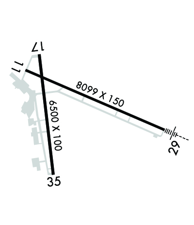
| Lat: N 3853.4 Long: W 09002.8 Elev: 544 Var: +01 Longest Runway: 8099 | ||
| Clr Del: 120.2 Dept. ATIS: 128.0 Arr. ATIS: 128.0 AWOS: 128.0 Ground: 120.2 Tower: 126.0 | ||
| ||||||||||||||||||||||||||||||||||||||||||||
| ||||||||||||||||||||||||||||||||||||||||||||
| ||||||||||||||||||||||||||||||||||||||||||||
| Rwy | Rwy | |||||||
| 8099x150 | 8099' | 8099x150 | 8099' | 108.50 - 294° | ||||
| 6500x100 | 6500' | 6500x100 | 6500' | |||||
| Runway ID | Single Wheel | Double Wheel | Double Tandem Wheel | Dual Double Wheel |
| 11/29 | 109,000 | 144,000 | 217,000 | N/A |
| 17/35 | 39,500 | 52,000 | N/A | N/A |
| These numbers are Advisory and are not limits. The Airport Manager should have more accurate Weight Limits | ||||
 Airport Diagram might not be current. | |
| Facility Name: | ST LOUIS RGNL |
| City Name: | ALTON/ST LOUIS |
| County: | MADISON |
| State abbrev: | IL |
| State Name: | ILLINOIS |
| Ownership: | PUBLICLY OWNED |
| Use: | OPEN TO THE PUBLIC |
| Owner's Name: | ST. LOUIS REGIONAL |
| Address: | 8 TERMINAL DR SUITE 1 |
| EAST ALTON, IL 62024 | |
| Owner's Phone: | 618-259-2531 |
| Manager's Name: | DAVID MILLER |
| Address: | 8 TERMINAL DR, SUITE 1 |
| EAST ALTON, IL 62024 | |
| Phone: | 618-259-2531 |
| FAA Region: | GREAT LAKES |
| FAA Field Office: | CHI |
| Date | Sunrise | Sunset |
|---|---|---|
| 09/24/21 Friday | 6:49 | 18:54 |
| 09/25/21 Saturday | 6:50 | 18:53 |
| 09/26/21 Sunday | 6:51 | 18:51 |
| 09/27/21 Monday | 6:52 | 18:50 |
| 09/28/21 Tuesday | 6:53 | 18:48 |
| 09/29/21 Wednesday | 6:54 | 18:46 |
| 09/30/21 Thursday | 6:55 | 18:45 |
| 10/01/21 Friday | 6:56 | 18:43 |
| 10/02/21 Saturday | 6:57 | 18:42 |
| 10/03/21 Sunday | 6:58 | 18:40 |
| 10/04/21 Monday | 6:59 | 18:39 |
| 10/05/21 Tuesday | 7:00 | 18:37 |
| 10/06/21 Wednesday | 7:01 | 18:35 |
| 10/07/21 Thursday | 7:02 | 18:34 |
| Airport Attendance Schedule | 7 Days A Week 0700-2200; ATTENDANT AFT HR - CALL 618-259-3230 OR 258-1005. |
| Airport Status | OPERATIONAL (This Status can change at any time - please check NOTAMS) |
| Airport Lighting Schedule | ACTVT MALSR RWY 29; REIL RWY 11 - CTAF. WHEN ATCT CLSD PAPI 11, 17, 35; HIRL RWY 11/29; MIRL RWY 17/35 PRESET ON LOW INTST, TO INCR INTST & ACTVT - CTAF. |
| Airport Storage Available | Tie Downs, Hanger |
| Extra Services Available | Charter, Flight Instruction, Aircraft Rental |
| Wind Indicator | YES - (lighted) |
| Control Tower | YES |
| CTAF Frequency | 126.000 |
| Unicom Frequency | 122.950 |
| Rotating Beacon Color | CLEAR-GREEN (Light Land Airport) |
| Segmented Circle | NO |
| Landing Fee | NO |
| Airport Inspected | FEDERAL - performed by FAA AIRPORTS FIELD PERSONNEL |
| Inspection Date | 11/30/2018 |
| Type of Fuel Available | Grade 100LL, JET A (freeze point -40C) |
| Airframe Repair Service | MAJOR |
| Power Plant Repair Service | MAJOR |
| Latitude | N3853.4 |
| Longitude | W09002.8 (ESTIMATED) |
| Arpt Elevation | 543ft (SURVEYED) |
| Magnetic Variation | 01W |
| 4 miles E | of ALTON/ST LOUIS |
| Traffic Pattern Altitude | |
| Sectional Chart | ST LOUIS |
| Operations (Reported) | Yearly | Avg. Daily |
|---|---|---|
| General Aviation Transient | 10809 | 30 |
| General Aviation Local | 14040 | 38 |
| Air Taxi | 3943 | 11 |
| Commerical | 16 | 0 |
| Commuter | 0 | 0 |
| Military | 642 | 2 |
| Aircraft based on Field | |
|---|---|
| General Aviation Singles | 36 |
| General Aviation Multi | 0 |
| Jet Aircraft | 1 |
| General Aviation Helicopters | 0 |
| Military Aircraft | 0 |
| Gliders | 0 |
| Ultralights | 0 |
| FSS on field | NO |
| FSS tie-in | SAINT LOUIS |
| FSS Phone | 1-800-WX-BRIEF |
| Who issues Notams | ALN |
| Notam D service at airport | YES |
| ARTCC Name | KANSAS CITY |
| Airport Certification | CLSD TO SKED ACR OPS WITH GTR THAN 9 PSGR SEATS. UNSKED ACR OPS GTR THAN 30 PSGR SEATS RQR 90 DAY PPR - CTC AMGR. |
| Aircraft Rescue & Firefighting Index | AIRPORT HAS A CERTIFICATE UNDER CFR PART 139 |
| Airport of Entry | No |
| Custom Landing Rights | No |
| Joint Civil/Military | No |
| Military Landing rights | YES |
| NATIONAL PLAN OF INTEGRATED AIRPORT SYSTEMS (NPIAS) |
| GRANT AGREEMENTS UNDER FAAP/ADAP/AIP |
| ASSURANCES PURSUANT TO TITLE VI, CIVIL RIGHTS ACT OF 1964 |
| RWY 11 & 17 APCH ENDS CLOSELY ALIGNED; VERIFY CORRECT COMPASS HDG PRIOR TO DEP. |
| INDEX C FFR EQUIP AVBL WITH 30-MIN PPR. |
Airport Communications & Frequencies:
| |||||||||||||||||||||||||||
| Runway: 11 | Runway: 29 | ||
| Mag heading: | 114° | Mag heading: | 294° |
| Rwy Slope: | -.14% Down | Rwy Slope: | .14% Up |
| Approach: | Approach: | ILS/DME | |
| Pattern: | Left Traffic | Pattern: | Left Traffic |
| Markings: | PRECISION INSTRUMENT | Markings: | PRECISION INSTRUMENT |
| Marking Condition: | GOOD | Marking Condition: | GOOD |
| Arresting Dev: | Arresting Dev: | ||
| Lat & Long: | N3853.7 W09003.3 | Lat. & Long.: | N3853.2 W09001.7 |
| Elev: | 537.8 ft. MSL | Elev: | 526.4 ft. MSL |
| TCH: | 44 ft. AGL | TCH: | |
| Visual Glide Path: | 3.00 degrees | Visual Glide Path: | |
| Displaced Threshold: | No | Displaced Threshold: | No |
| Touchdown Zone: | YES | Touchdown Zone: | YES |
| Touchdown Elev.: | 539.2 feet | Touchdown Elev.: | 531.2 feet |
| Visual Glide Slope: | 4-Light PAPI on RIGHT side of Runway | Visual Glide Slope: | |
| RVR Equipment: | RVR Equipment: | ||
| RVV Equipment: | NO | RVV Equipment: | NO |
| Approach Lights: | Approach Lights: | MALSR - 1,400 foot medium intensity approach lighting system with runway alignment indicator lights | |
| REIL: | YES | REIL: | NO |
| Centerline Lights: | NO | Centerline Lights: | NO |
| Touchdown lights: | NO | Touchdown lights: | NO |
| Runway Category: | Runway with a Non-precision Approach having visibility minimums greater than 3/4 mile | Runway Category: | Precision Instrument Runway |
| Declared Distances: | TORA:8099' TODA:8099' ASDA:8099' LDA:8099' | Declared Distances: | TORA:8099' TODA:8099' ASDA:8099' LDA:8099' |
| Obstructions: | TREE | Obstructions: | |
| Marked: | NOT Marked/Lighted | Marked: | |
| Clearance slope: | 30:1 | Clearance slope: | 50:1 |
| Obstruction height: | 35 feet AGL | Obstruction height: | |
| Dist. from runway: | 1275 feet | Dist. from runway: | |
| Centerline offset: | 475 right of centerline | Centerline offset: | |
| Comments: | Comments: |
| Runway: 17 | Runway: 35 | ||
| Mag heading: | 174° | Mag heading: | 354° |
| Rwy Slope: | .14% Up | Rwy Slope: | -.14% Down |
| Approach: | Approach: | ||
| Pattern: | Left Traffic | Pattern: | Left Traffic |
| Markings: | NONPRECISION INSTRUMENT | Markings: | NONPRECISION INSTRUMENT |
| Marking Condition: | FAIR | Marking Condition: | FAIR |
| Arresting Dev: | Arresting Dev: | ||
| Lat & Long: | N3853.9 W09003.1 | Lat. & Long.: | N3852.8 W09003.0 |
| Elev: | 533.4 ft. MSL | Elev: | 542.3 ft. MSL |
| TCH: | 43 ft. AGL | TCH: | 43 ft. AGL |
| Visual Glide Path: | 3.00 degrees | Visual Glide Path: | 3.00 degrees |
| Displaced Threshold: | No | Displaced Threshold: | No |
| Touchdown Zone: | YES | Touchdown Zone: | YES |
| Touchdown Elev.: | 542.9 feet | Touchdown Elev.: | 543.5 feet |
| Visual Glide Slope: | 4-Light PAPI on LEFT side of Runway | Visual Glide Slope: | 4-Light PAPI on LEFT side of Runway |
| RVR Equipment: | RVR Equipment: | ||
| RVV Equipment: | NO | RVV Equipment: | NO |
| Approach Lights: | Approach Lights: | ||
| REIL: | NO | REIL: | NO |
| Centerline Lights: | NO | Centerline Lights: | NO |
| Touchdown lights: | NO | Touchdown lights: | NO |
| Runway Category: | Runway with a Non-precision Approach having visibility minimums greater than 3/4 mile | Runway Category: | Runway with a Non-precision Approach having visibility minimums greater than 3/4 mile |
| Declared Distances: | Declared Distances: | ||
| Obstructions: | TREE | Obstructions: | TREES |
| Marked: | NOT Marked/Lighted | Marked: | NOT Marked/Lighted |
| Clearance slope: | 38:1 | Clearance slope: | 36:1 |
| Obstruction height: | 18 feet AGL | Obstruction height: | 32 feet AGL |
| Dist. from runway: | 896 feet | Dist. from runway: | 1379 feet |
| Centerline offset: | 139 left of centerline | Centerline offset: | 72 feet right of centerline |
| Comments: | Comments: |
Thanks for using FltPlan.com
all rights reserved © 1999-2021 by Flight Plan LLC
