| BLAKE FIELD DELTA CO |
| |
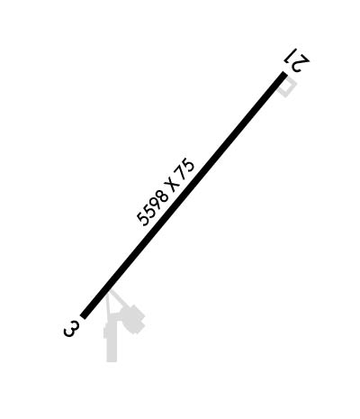
| Lat: N 3847.1 Long: W 10803.7 Elev: 5193 Var: -10 Longest Runway: 5598 | ||
| AWOS: 134.0 CTAF: 122.8 | ||
| |||||||||||||||||||||||||||||||||||||||||||||||||||||||||||||
| |||||||||||||||||||||||||||||||||||||||||||||||||||||||||||||
| |||||||||||||||||||||||||||||||||||||||||||||||||||||||||||||
| Rwy | Rwy | |||||||
| 5598x75 | 5598' | 5598x75 | 5598' | |||||
| 2494x60 | 2494' | 2494x60 | 2494' | |||||
| Runway ID | Single Wheel | Double Wheel | Double Tandem Wheel | Dual Double Wheel |
| 03/21 | 30,000 | 30,000 | N/A | N/A |
| 14/32 | N/A | N/A | N/A | N/A |
| These numbers are Advisory and are not limits. The Airport Manager should have more accurate Weight Limits | ||||
 Airport Diagram might not be current. | |
| Facility Name: | BLAKE FLD |
| City Name: | DELTA |
| County: | DELTA |
| State abbrev: | CO |
| State Name: | COLORADO |
| Ownership: | PUBLICLY OWNED |
| Use: | OPEN TO THE PUBLIC |
| Owner's Name: | COUNTY OF DELTA |
| Address: | DELTA COUNTY |
| DELTA, CO 81416 | |
| Owner's Phone: | (970) 874-5181 |
| Manager's Name: | MARK HUSMANN |
| Address: | 870 - 1575 ROAD |
| DELTA, CO 81416 | |
| Phone: | 970-874-5181 |
| FAA Region: | NORTHWEST MOUNTAIN |
| FAA Field Office: | DEN |
| Date | Sunrise | Sunset |
|---|---|---|
| 09/24/21 Friday | 7:02 | 19:06 |
| 09/25/21 Saturday | 7:02 | 19:05 |
| 09/26/21 Sunday | 7:03 | 19:03 |
| 09/27/21 Monday | 7:04 | 19:02 |
| 09/28/21 Tuesday | 7:05 | 19:00 |
| 09/29/21 Wednesday | 7:06 | 18:58 |
| 09/30/21 Thursday | 7:07 | 18:57 |
| 10/01/21 Friday | 7:08 | 18:55 |
| 10/02/21 Saturday | 7:09 | 18:54 |
| 10/03/21 Sunday | 7:10 | 18:52 |
| 10/04/21 Monday | 7:11 | 18:51 |
| 10/05/21 Tuesday | 7:12 | 18:49 |
| 10/06/21 Wednesday | 7:13 | 18:47 |
| 10/07/21 Thursday | 7:14 | 18:46 |
| Airport Attendance Schedule | MON-FRI 0800-1700; AFT HRS EMERG FONE, SHERIFF DEPT 970-874-2000/AFT HRS SVC 970-209-0883. |
| Airport Status | OPERATIONAL (This Status can change at any time - please check NOTAMS) |
| Airport Lighting Schedule | ACTVT REIL RWY 03 & 21; MIRL RWY 03/21 - CTAF. PAPI RWY 03 & 21 ON CONSLY. |
| Airport Storage Available | Tie Downs, Hanger |
| Extra Services Available | Air Ambulance, Glider, Flight Instruction, Aircraft Rental, Glider Towing |
| Wind Indicator | YES - (lighted) |
| Control Tower | NO |
| CTAF Frequency | 122.800 |
| Unicom Frequency | 122.800 |
| Rotating Beacon Color | CLEAR-GREEN (Light Land Airport) |
| Segmented Circle | YES |
| Landing Fee | NO |
| Airport Inspected | STATE - performed by STATE AERONAUTICAL PERSONNEL |
| Inspection Date | 07/26/2021 |
| Type of Fuel Available | Grade 100LL, JET A (freeze point -40C) |
| Airframe Repair Service | MAJOR |
| Power Plant Repair Service | MINOR |
| Latitude | N3847.1 |
| Longitude | W10803.7 (ESTIMATED) |
| Arpt Elevation | 5193ft (SURVEYED) |
| Magnetic Variation | 10E |
| 3 miles N | of DELTA |
| Traffic Pattern Altitude | 1007 |
| Sectional Chart | DENVER |
| Operations (Reported) | Yearly | Avg. Daily |
|---|---|---|
| General Aviation Transient | 1455 | 4 |
| General Aviation Local | 1455 | 4 |
| Air Taxi | 0 | 0 |
| Commerical | 0 | 0 |
| Commuter | 0 | 0 |
| Military | 0 | 0 |
| Aircraft based on Field | |
|---|---|
| General Aviation Singles | 46 |
| General Aviation Multi | 1 |
| Jet Aircraft | 0 |
| General Aviation Helicopters | 1 |
| Military Aircraft | 0 |
| Gliders | 1 |
| Ultralights | 0 |
| FSS on field | NO |
| FSS tie-in | DENVER |
| FSS Phone | 1-800-WX-BRIEF |
| Who issues Notams | DEN |
| Notam D service at airport | YES |
| ARTCC Name | DENVER |
| Airport Certification | |
| Aircraft Rescue & Firefighting Index | None |
| Airport of Entry | No |
| Custom Landing Rights | No |
| Joint Civil/Military | No |
| Military Landing rights | YES |
| NATIONAL PLAN OF INTEGRATED AIRPORT SYSTEMS (NPIAS) |
| GRANT AGREEMENTS UNDER FAAP/ADAP/AIP |
| CONVEYANCE UNDER SCETION 16, FEDERAL AIRPORT ACT OF 1946 OR SECTION 23, AIRPORT AND AIRWAY DEVELOPMENT ACT OF 1970 |
| ASSURANCES PURSUANT TO TITLE VI, CIVIL RIGHTS ACT OF 1964 |
| ANTELOPE ON AND INVOF ARPT. |
| RY 21 HAS TURN AROUND TAXI HAS BLUE/WHITE REFLECTORS. |
| RY 03/21 SLOPES UP TO THE NE. |
| RY 03/21 HAS 4 FT BUSHES 15-20 FT FROM RY EDGE ON BOTH SIDES IN VARIOUS PLACES. |
| 24 HOUR SELF SERVE FUEL AVBL. |
| RY 3 HAS +4 FT FENCE 580 FT FM THLD OB. |
| POWER LINES 2640' NW RY 03/21, +52 FT AGL. |
| FOR CD CTC DENVER ARTCC AT 303-651-4257. |
Airport Communications & Frequencies:
| |||||||||
| Runway: 03 | Runway: 21 | ||
| Mag heading: | 32° | Mag heading: | 212° |
| Rwy Slope: | 1.46% Up | Rwy Slope: | -1.46% Down |
| Approach: | Approach: | ||
| Pattern: | Right Traffic | Pattern: | Left Traffic |
| Markings: | NONPRECISION INSTRUMENT | Markings: | NONPRECISION INSTRUMENT |
| Marking Condition: | GOOD | Marking Condition: | GOOD |
| Arresting Dev: | Arresting Dev: | ||
| Lat & Long: | N3846.8 W10804.2 | Lat. & Long.: | N3847.5 W10803.4 |
| Elev: | 5111.1 ft. MSL | Elev: | 5193.1 ft. MSL |
| TCH: | 40 ft. AGL | TCH: | 37 ft. AGL |
| Visual Glide Path: | 3.00 degrees | Visual Glide Path: | 3.00 degrees |
| Displaced Threshold: | No | Displaced Threshold: | No |
| Touchdown Zone: | YES | Touchdown Zone: | YES |
| Touchdown Elev.: | 5156.6 feet | Touchdown Elev.: | 5193.1 feet |
| Visual Glide Slope: | 2-Light PAPI on LEFT side of Runway | Visual Glide Slope: | 2-Light PAPI on LEFT side of Runway |
| RVR Equipment: | RVR Equipment: | ||
| RVV Equipment: | NO | RVV Equipment: | NO |
| Approach Lights: | Approach Lights: | ||
| REIL: | YES | REIL: | YES |
| Centerline Lights: | NO | Centerline Lights: | NO |
| Touchdown lights: | NO | Touchdown lights: | NO |
| Runway Category: | Runway with a Visual Approach | Runway Category: | Runway with a Visual Approach |
| Declared Distances: | Declared Distances: |
| Runway: 14 | Runway: 32 | ||
| Mag heading: | 139° | Mag heading: | 319° |
| Rwy Slope: | -1.42% Down | Rwy Slope: | 1.42% Up |
| Approach: | Approach: | ||
| Pattern: | Left Traffic | Pattern: | Left Traffic |
| Markings: | Markings: | ||
| Marking Condition: | Marking Condition: | ||
| Arresting Dev: | Arresting Dev: | ||
| Lat & Long: | N3847.2 W10803.6 | Lat. & Long.: | N3846.9 W10803.4 |
| Elev: | 5151.6 ft. MSL | Elev: | 5116.3 ft. MSL |
| TCH: | TCH: | ||
| Visual Glide Path: | Visual Glide Path: | ||
| Displaced Threshold: | No | Displaced Threshold: | No |
| Touchdown Zone: | YES | Touchdown Zone: | YES |
| Touchdown Elev.: | 5151.6 feet | Touchdown Elev.: | 5151.6 feet |
| Visual Glide Slope: | Visual Glide Slope: | ||
| RVR Equipment: | RVR Equipment: | ||
| RVV Equipment: | NO | RVV Equipment: | NO |
| Approach Lights: | Approach Lights: | ||
| REIL: | NO | REIL: | NO |
| Centerline Lights: | NO | Centerline Lights: | NO |
| Touchdown lights: | NO | Touchdown lights: | NO |
| Runway Category: | Runway Category: | ||
| Declared Distances: | Declared Distances: |
Thanks for using FltPlan.com
all rights reserved © 1999-2021 by Flight Plan LLC