| HABERSHAM COUNTY CORNELIA GA |
| |
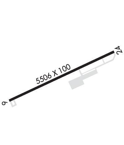
| Lat: N 3430.0 Long: W 08333.4 Elev: 1448 Var: +06 Longest Runway: 5503 | ||
| AWOS: 119.17 CTAF: 122.7 | ||
| ||||||||||||||||||||||||||||||||||||||||||||||||||||||||||||||||||||
| ||||||||||||||||||||||||||||||||||||||||||||||||||||||||||||||||||||
| ||||||||||||||||||||||||||||||||||||||||||||||||||||||||||||||||||||
| Rwy | Rwy | |||||||
| 5503x100 | 4111' | 5503x100 | 5503' | |||||
| Runway ID | Single Wheel | Double Wheel | Double Tandem Wheel | Dual Double Wheel |
| 06/24 | 30,000 | N/A | N/A | N/A |
| These numbers are Advisory and are not limits. The Airport Manager should have more accurate Weight Limits | ||||
 Airport Diagram might not be current. | |
| Facility Name: | HABERSHAM COUNTY |
| City Name: | CORNELIA |
| County: | HABERSHAM |
| State abbrev: | GA |
| State Name: | GEORGIA |
| Ownership: | PUBLICLY OWNED |
| Use: | OPEN TO THE PUBLIC |
| Owner's Name: | HABERSHAM COUNTY |
| Address: | 555 MONROE STREET, UNIT 20 |
| CLARKESVILLE, GA 30523 | |
| Owner's Phone: | (706) 839-0200 |
| Manager's Name: | BILL HARDEN |
| Address: | 1112 AIRPORT ROAD |
| CORNELIA, GA 30531 | |
| Phone: | 706-839-0247; ARPT PHONE NUMBER - (706) 778-0198. |
| FAA Region: | SOUTHERN |
| FAA Field Office: | ATL |
| Date | Sunrise | Sunset |
|---|---|---|
| 06/08/26 Monday | 6:21 | 20:45 |
| 06/09/26 Tuesday | 6:21 | 20:46 |
| 06/10/26 Wednesday | 6:21 | 20:46 |
| 06/11/26 Thursday | 6:21 | 20:47 |
| 06/12/26 Friday | 6:21 | 20:47 |
| 06/13/26 Saturday | 6:21 | 20:48 |
| 06/14/26 Sunday | 6:21 | 20:48 |
| 06/15/26 Monday | 6:21 | 20:48 |
| 06/16/26 Tuesday | 6:21 | 20:49 |
| 06/17/26 Wednesday | 6:21 | 20:49 |
| 06/18/26 Thursday | 6:21 | 20:49 |
| 06/19/26 Friday | 6:22 | 20:50 |
| 06/20/26 Saturday | 6:22 | 20:50 |
| 06/21/26 Sunday | 6:22 | 20:50 |
| Airport Attendance Schedule | 7 Days A Week 0800-1800 |
| Airport Status | OPERATIONAL (This Status can change at any time - please check NOTAMS) |
| Airport Lighting Schedule | MIRL RWY 06/24 PRESET ON LOW INTST DUSK-2200; TO INCR INTST - CTAF. AFT 2200 ACTVT - CTAF. |
| Airport Storage Available | Tie Downs |
| Extra Services Available | Flight Instruction, Aircraft Rental |
| Wind Indicator | YES - (lighted) |
| Control Tower | NO |
| CTAF Frequency | 122.700 |
| Unicom Frequency | 122.700 |
| Rotating Beacon Color | WG |
| Segmented Circle | YES |
| Landing Fee | NO |
| Airport Inspected | STATE - performed by STATE AERONAUTICAL PERSONNEL |
| Inspection Date | 06/13/2025 |
| Type of Fuel Available | Grade 100LL, JET A |
| Airframe Repair Service | MAJOR |
| Power Plant Repair Service | MAJOR |
| Latitude | N3430.0 |
| Longitude | W08333.4 (ESTIMATED) |
| Arpt Elevation | 1447ft (SURVEYED) |
| Magnetic Variation | 06W |
| 2 miles SW | of CORNELIA |
| Traffic Pattern Altitude | |
| Sectional Chart | ATLANTA |
| Operations (Reported) | Yearly | Avg. Daily |
|---|---|---|
| General Aviation Transient | 0 | 0 |
| General Aviation Local | 0 | 0 |
| Air Taxi | 0 | 0 |
| Commerical | 0 | 0 |
| Commuter | 0 | 0 |
| Military | 0 | 0 |
| Aircraft based on Field | |
|---|---|
| General Aviation Singles | 0 |
| General Aviation Multi | 0 |
| Jet Aircraft | 0 |
| General Aviation Helicopters | 0 |
| Military Aircraft | 0 |
| Gliders | 0 |
| Ultralights | 0 |
| FSS on field | NO |
| FSS tie-in | MACON |
| FSS Phone | 1-800-WX-BRIEF |
| Who issues Notams | MCN |
| Notam D service at airport | YES |
| ARTCC Name | ATLANTA |
| Airport Certification | |
| Aircraft Rescue & Firefighting Index | None |
| Airport of Entry | No |
| Custom Landing Rights | No |
| Joint Civil/Military | No |
| Military Landing rights | YES |
| NATIONAL PLAN OF INTEGRATED AIRPORT SYSTEMS (NPIAS) |
| GRANT AGREEMENTS UNDER FAAP/ADAP/AIP |
| ASSURANCES PURSUANT TO TITLE VI, CIVIL RIGHTS ACT OF 1964 |
| DEER & WILDLIFE ON OR INVOF ARPT. |
| FOR CD CTC ATLANTA ARTCC AT 770-210-7692. |
| TWY A BTN TWY D AND TWY C CLSD TO ACFT WINGSPAN MORE THAN 80 FT. |
Airport Communications & Frequencies:
| |||||||||
| Runway: 06 | Runway: 24 | ||
| Mag heading: | 63° | Mag heading: | 243° |
| Rwy Slope: | .81% Up | Rwy Slope: | -.81% Down |
| Approach: | Approach: | ||
| Pattern: | Left Traffic | Pattern: | Left Traffic |
| Markings: | NONPRECISION INSTRUMENT | Markings: | NONPRECISION INSTRUMENT |
| Marking Condition: | GOOD | Marking Condition: | GOOD |
| Arresting Dev: | Arresting Dev: | ||
| Lat & Long: | N3429.7 W08333.9 | Lat. & Long.: | N3430.2 W08332.9 |
| Elev: | 1403.1 ft. MSL | Elev: | 1447.4 ft. MSL |
| TCH: | 45 ft. AGL | TCH: | 38 ft. AGL |
| Visual Glide Path: | 3.00 degrees | Visual Glide Path: | 3.00 degrees |
| Displaced Threshold: | 1392 feet | Displaced Threshold: | No |
| Touchdown Zone: | YES | Touchdown Zone: | YES |
| Touchdown Elev.: | 1446.2 feet | Touchdown Elev.: | 1447.9 feet |
| Visual Glide Slope: | 4-Light PAPI on LEFT side of Runway | Visual Glide Slope: | 4-Light PAPI on LEFT side of Runway |
| RVR Equipment: | RVR Equipment: | ||
| RVV Equipment: | NO | RVV Equipment: | NO |
| Approach Lights: | Approach Lights: | ||
| REIL: | NO | REIL: | NO |
| Centerline Lights: | NO | Centerline Lights: | NO |
| Touchdown lights: | NO | Touchdown lights: | NO |
| Runway Category: | Runway with a Non-precision Approach having visibility minimums greater than 3/4 mile | Runway Category: | Runway with a Non-precision Approach having visibility minimums greater than 3/4 mile |
| Declared Distances: | TORA:5503' TODA:5503' ASDA:5503' LDA:4111' | Declared Distances: | TORA:5503' TODA:5503' ASDA:5503' LDA:5503' |
| Obstructions: | TREES | Obstructions: | TREES |
| Marked: | NOT Marked/Lighted | Marked: | NOT Marked/Lighted |
| Clearance slope: | 8:1; APCH RATIO 26:1 TO DSPLCD THR. | Clearance slope: | 11:1 |
| Obstruction height: | 58 feet AGL | Obstruction height: | 23 feet AGL |
| Dist. from runway: | 664 feet | Dist. from runway: | 453 feet |
| Centerline offset: | 307 left of centerline | Centerline offset: | 163 feet left of centerline |
| Comments: | Comments: |
Thanks for using FltPlan.com
all rights reserved © 1999-2026 by Flight Plan LLC