
| CORONA MUNI CORONA CA |
| |
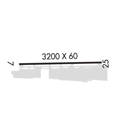
| Lat: N 3353.9 Long: W 11736.1 Elev: 533 Var: -14 Longest Runway: 3200 | ||
| AWOS: 132.17 CTAF: 122.7 | ||
| ||||||||||||||||||||||||||||||||
| ||||||||||||||||||||||||||||||||
| ||||||||||||||||||||||||||||||||
| Rwy | Rwy | |||||||
| 3200x60 | 3006' | 3200x60 | 3004' | |||||
| Runway ID | Single Wheel | Double Wheel | Double Tandem Wheel | Dual Double Wheel |
| 07/25 | 12,000 | N/A | N/A | N/A |
| These numbers are Advisory and are not limits. The Airport Manager should have more accurate Weight Limits | ||||
 Airport Diagram might not be current. | |
| Facility Name: | CORONA MUNI |
| City Name: | CORONA |
| County: | RIVERSIDE |
| State abbrev: | CA |
| State Name: | CALIFORNIA |
| Ownership: | PUBLICLY OWNED |
| Use: | OPEN TO THE PUBLIC |
| Owner's Name: | CITY OF CORONA; ON LEASE TO CITY OF CORONA FROM ARMY CORPS OF ENGINEERS. |
| Address: | 400 SOUTH VICENTIA AVE |
| CORONA, CA 92882 | |
| Owner's Phone: | 951-736-2289 |
| Manager's Name: | MOSES CORTEZ; AIRPORT ADDRESS: 1900 AVIATION DRIVE, CORONA, CA 92880. |
| Address: | 400 SOUTH VICENTIA AVE, SUITE 225 |
| CORONA, CA 92882 | |
| Phone: | 951-739-4957 |
| FAA Region: | WESTERN-PACIFIC |
| FAA Field Office: | LAX |
| Date | Sunrise | Sunset |
|---|---|---|
| 06/12/26 Friday | 5:39 | 20:02 |
| 06/13/26 Saturday | 5:39 | 20:02 |
| 06/14/26 Sunday | 5:39 | 20:03 |
| 06/15/26 Monday | 5:39 | 20:03 |
| 06/16/26 Tuesday | 5:39 | 20:03 |
| 06/17/26 Wednesday | 5:39 | 20:04 |
| 06/18/26 Thursday | 5:39 | 20:04 |
| 06/19/26 Friday | 5:39 | 20:04 |
| 06/20/26 Saturday | 5:40 | 20:04 |
| 06/21/26 Sunday | 5:40 | 20:05 |
| 06/22/26 Monday | 5:40 | 20:05 |
| 06/23/26 Tuesday | 5:40 | 20:05 |
| 06/24/26 Wednesday | 5:40 | 20:05 |
| 06/25/26 Thursday | 5:41 | 20:05 |
| Airport Attendance Schedule | MON-FRI 0700-1700 |
| Airport Status | OPERATIONAL (This Status can change at any time - please check NOTAMS) |
| Airport Lighting Schedule | ACTVT MIRL RY 07/25 VASI & REIL RY 25 - CTAF. |
| Airport Storage Available | Tie Downs |
| Extra Services Available | Flight Instruction, Aircraft Rental, Aircraft Sales |
| Wind Indicator | YES - (lighted) |
| Control Tower | NO |
| CTAF Frequency | 122.700 |
| Unicom Frequency | 122.700 |
| Rotating Beacon Color | WG |
| Segmented Circle | YES |
| Landing Fee | NO |
| Airport Inspected | STATE - performed by STATE AERONAUTICAL PERSONNEL |
| Inspection Date | 07/24/2025 |
| Type of Fuel Available | Grade 100LL |
| Airframe Repair Service | MAJOR |
| Power Plant Repair Service | MAJOR |
| Latitude | N3353.9 |
| Longitude | W11736.1 (ESTIMATED) |
| Arpt Elevation | 533ft (SURVEYED) |
| Magnetic Variation | 14E |
| 3 miles NW | of CORONA |
| Traffic Pattern Altitude | NO TURNS ONTO XW LEG TIL ACFT IS WI 300 FT OF RECOMMENDED TPA. |
| Sectional Chart | LOS ANGELES |
| Operations (Reported) | Yearly | Avg. Daily |
|---|---|---|
| General Aviation Transient | 0 | 0 |
| General Aviation Local | 0 | 0 |
| Air Taxi | 0 | 0 |
| Commerical | 0 | 0 |
| Commuter | 0 | 0 |
| Military | 0 | 0 |
| Aircraft based on Field | |
|---|---|
| General Aviation Singles | 0 |
| General Aviation Multi | 0 |
| Jet Aircraft | 0 |
| General Aviation Helicopters | 0 |
| Military Aircraft | 0 |
| Gliders | 0 |
| Ultralights | 0 |
| FSS on field | NO |
| FSS tie-in | RIVERSIDE |
| FSS Phone | 1-800-WX-BRIEF |
| Who issues Notams | AJO |
| Notam D service at airport | YES |
| ARTCC Name | LOS ANGELES |
| Airport Certification | |
| Aircraft Rescue & Firefighting Index | None |
| Airport of Entry | No |
| Custom Landing Rights | No |
| Joint Civil/Military | No |
| Military Landing rights | No |
| NATIONAL PLAN OF INTEGRATED AIRPORT SYSTEMS (NPIAS) |
| THIS AIRPORT HAS BEEN SURVEYED BY THE NATIONAL GEODETIC SURVEY. |
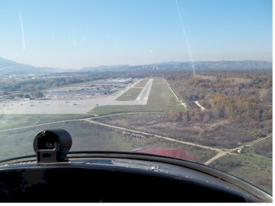
| NOISE ABATEMENT PROCEDURES: RY 25 STRAIGHT-IN APCH NOT RECOMMENDED. AVOID FLYING OVER HOUSES ON BLUFF AT EAST END. FLY OVER WASH/CREEK. RY 07 REQUIRES A 15 DEG RIGHT TURN AT DEP END TO FOLLOW WASH/CREEK. |
| UNLGTD TWR 828 FT MSL 3 MILES E OF ARPT. |
| NO INTERSECTION TAKEOFFS. |
| NO TOUCH AND GO OPERATIONS ON WKNDS AND HOLS. |
| NO HELICOPTER TRNG AFTER 2000 |
| FOR CD CTC SOCAL APCH AT 800-448-3724. |
Airport Communications & Frequencies:
| ||||||||||||||||||||||||||||||||||||
| Runway: 07 | Runway: 25 | ||
| Mag heading: | 75° | Mag heading: | 255° |
| Rwy Slope: | .56% Up | Rwy Slope: | -.56% Down |
| Approach: | Approach: | ||
| Pattern: | Right Traffic | Pattern: | Left Traffic |
| Markings: | BASIC | Markings: | BASIC |
| Marking Condition: | GOOD | Marking Condition: | GOOD |
| Arresting Dev: | Arresting Dev: | ||
| Lat & Long: | N3353.9 W11736.5 | Lat. & Long.: | N3353.9 W11735.8 |
| Elev: | 515.0 ft. MSL | Elev: | 533.0 ft. MSL |
| TCH: | TCH: | 34 ft. AGL | |
| Visual Glide Path: | Visual Glide Path: | 4.00 degrees | |
| Displaced Threshold: | 194 feet | Displaced Threshold: | 196 feet |
| Touchdown Zone: | YES | Touchdown Zone: | YES |
| Touchdown Elev.: | 533.0 feet | Touchdown Elev.: | 532.2 feet |
| Visual Glide Slope: | Visual Glide Slope: | 4-BOX VASI ON LEFT SIDE OF RUNWAY | |
| RVR Equipment: | RVR Equipment: | ||
| RVV Equipment: | NO | RVV Equipment: | NO |
| Approach Lights: | Approach Lights: | ||
| REIL: | NO | REIL: | YES |
| Centerline Lights: | NO | Centerline Lights: | NO |
| Touchdown lights: | NO | Touchdown lights: | NO |
| Runway Category: | Runway with a Visual Approach | Runway Category: | Runway with a Visual Approach |
| Declared Distances: | Declared Distances: | ||
| Obstructions: | TREES | Obstructions: | FENCE |
| Marked: | NOT Marked/Lighted | Marked: | LIGHTED |
| Clearance slope: | 5:1; RWY 07 APCH RATIO TO DSPLCD THR 20:1 | Clearance slope: | RWY 25 APCH RATIO TO DSPLCD THR 34:1. |
| Obstruction height: | 40 feet AGL | Obstruction height: | 6 feet AGL |
| Dist. from runway: | 400 feet | Dist. from runway: | 200 feet |
| Centerline offset: | 265B | Centerline offset: | |
| Comments: | Comments: |
Thanks for using FltPlan.com
all rights reserved © 1999-2026 by Flight Plan LLC