
| AITKIN MUNI-STEVE KURTZ FIELD AITKIN MN |
| |
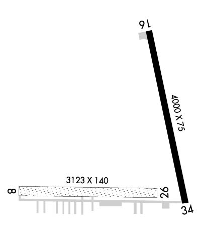
| Lat: N 4632.9 Long: W 09340.6 Elev: 1206 Var: -00 Longest Runway: 4000 | ||
| AWOS: 118.67 CTAF: 123.05 | ||
| ||||||||||||||||||||||||||||||||||||||||||||
| ||||||||||||||||||||||||||||||||||||||||||||
| ||||||||||||||||||||||||||||||||||||||||||||
| Rwy | Rwy | |||||||
| 3123x140 | 2883' | 3123x140 | 3123' | |||||
| 4000x75 | 4000' | 4000x75 | 4000' | |||||
| Runway ID | Single Wheel | Double Wheel | Double Tandem Wheel | Dual Double Wheel |
| 08/26 | N/A | N/A | N/A | N/A |
| 16/34 | 12,500 | N/A | N/A | N/A |
| These numbers are Advisory and are not limits. The Airport Manager should have more accurate Weight Limits | ||||
 Airport Diagram might not be current. | |
| Facility Name: | AITKIN MUNI-STEVE KURTZ FLD |
| City Name: | AITKIN |
| County: | AITKIN |
| State abbrev: | MN |
| State Name: | MINNESOTA |
| Ownership: | PUBLICLY OWNED |
| Use: | OPEN TO THE PUBLIC |
| Owner's Name: | COUNTY & CITY OF AITKIN |
| Address: | 109 1ST AVE. NW |
| AITKIN, MN 56431 | |
| Owner's Phone: | 218-927-2527; AIRPORT OPERATIONS DAY #218-839-1067 NIGHT #218-851-4502 |
| Manager's Name: | KATHLEEN RYAN |
| Address: | 109 1ST AVE. NW |
| AITKIN, MN 56431 | |
| Phone: | 218-927-2527 |
| FAA Region: | GREAT LAKES |
| FAA Field Office: | DMA |
| Date | Sunrise | Sunset |
|---|---|---|
| 09/24/21 Friday | 7:04 | 19:09 |
| 09/25/21 Saturday | 7:05 | 19:07 |
| 09/26/21 Sunday | 7:06 | 19:05 |
| 09/27/21 Monday | 7:08 | 19:03 |
| 09/28/21 Tuesday | 7:09 | 19:01 |
| 09/29/21 Wednesday | 7:10 | 18:59 |
| 09/30/21 Thursday | 7:12 | 18:57 |
| 10/01/21 Friday | 7:13 | 18:55 |
| 10/02/21 Saturday | 7:14 | 18:53 |
| 10/03/21 Sunday | 7:16 | 18:51 |
| 10/04/21 Monday | 7:17 | 18:49 |
| 10/05/21 Tuesday | 7:18 | 18:47 |
| 10/06/21 Wednesday | 7:20 | 18:45 |
| 10/07/21 Thursday | 7:21 | 18:43 |
| Airport Attendance Schedule | APR-OCT 7 Days A Week 0800-1700, NOV-MAR M-F 0900-1700 |
| Airport Status | OPERATIONAL (This Status can change at any time - please check NOTAMS) |
| Airport Lighting Schedule | MIRL RY 16/34 PRESET TO LOW, TO INCR INTST AND ACTVT REIL RY 16/34; VASI RY 16/34; MIRL RY 16/34 - CTAF. |
| Airport Storage Available | Tie Downs, Hanger |
| Extra Services Available | Flight Instruction, Aircraft Sales |
| Wind Indicator | YES - (lighted) |
| Control Tower | NO |
| CTAF Frequency | 123.050 |
| Unicom Frequency | 123.050 |
| Rotating Beacon Color | CLEAR-GREEN (Light Land Airport) |
| Segmented Circle | NO |
| Landing Fee | NO |
| Airport Inspected | STATE - performed by STATE AERONAUTICAL PERSONNEL |
| Inspection Date | 10/15/2018 |
| Type of Fuel Available | Grade 100LL, JET A (freeze point -40C); -10100LL AND JET A AVAILABLE 24 HOURS WITH CREDIT CARD, 218-839-1067 OR 218-839-6488 FOR SVC. |
| Airframe Repair Service | MAJOR |
| Power Plant Repair Service | MAJOR |
| Latitude | N4632.9 |
| Longitude | W09340.6 (ESTIMATED) |
| Arpt Elevation | 1206ft (SURVEYED) |
| Magnetic Variation | 00E |
| 2 miles NE | of AITKIN |
| Traffic Pattern Altitude | |
| Sectional Chart | TWIN CITIES |
| Operations (Reported) | Yearly | Avg. Daily |
|---|---|---|
| General Aviation Transient | 2800 | 8 |
| General Aviation Local | 13200 | 36 |
| Air Taxi | 0 | 0 |
| Commerical | 0 | 0 |
| Commuter | 0 | 0 |
| Military | 0 | 0 |
| Aircraft based on Field | |
|---|---|
| General Aviation Singles | 15 |
| General Aviation Multi | 0 |
| Jet Aircraft | 0 |
| General Aviation Helicopters | 0 |
| Military Aircraft | 0 |
| Gliders | 1 |
| Ultralights | 0 |
| FSS on field | NO |
| FSS tie-in | PRINCETON |
| FSS Phone | 1-800-WX-BRIEF |
| Who issues Notams | AIT |
| Notam D service at airport | YES |
| ARTCC Name | MINNEAPOLIS |
| Airport Certification | |
| Aircraft Rescue & Firefighting Index | None |
| Airport of Entry | No |
| Custom Landing Rights | No |
| Joint Civil/Military | No |
| Military Landing rights | YES |
| NATIONAL PLAN OF INTEGRATED AIRPORT SYSTEMS (NPIAS) |
| GRANT AGREEMENTS UNDER FAAP/ADAP/AIP |
| ASSURANCES PURSUANT TO TITLE VI, CIVIL RIGHTS ACT OF 1964 |
| GCO AVBL ON FREQ 121.725 THRU ZMP ARTCC AND PNM FSS. |
| FOR CD IF UNA VIA GCO CTC MINNEAPOLIS ARTCC AT 651-463-5588. |
| RWY 08/2 6 SKI EQUIPPED ACFT ONLY NOV-APR, CALL 218-927-4104 FOR RY CONDS. |
| RWY 16 CALM WIND RWY. |
Airport Communications & Frequencies:
| |||||||||
| Runway: 08 | Runway: 26 | ||
| Mag heading: | 88° | Mag heading: | 268° |
| Rwy Slope: | .07% Up | Rwy Slope: | -.07% Down |
| Approach: | Approach: | ||
| Pattern: | Left Traffic | Pattern: | Left Traffic |
| Markings: | NONE | Markings: | NONE |
| Marking Condition: | 08/26 MKD WITH YELLOW CONES. | Marking Condition: | |
| Arresting Dev: | Arresting Dev: | ||
| Lat & Long: | N4632.7 W09341.1 | Lat. & Long.: | N4632.8 W09340.4 |
| Elev: | 1203.5 ft. MSL | Elev: | 1205.8 ft. MSL |
| TCH: | TCH: | ||
| Visual Glide Path: | Visual Glide Path: | ||
| Displaced Threshold: | 240 feet | Displaced Threshold: | No |
| Touchdown Zone: | YES | Touchdown Zone: | YES |
| Touchdown Elev.: | 1205.8 feet | Touchdown Elev.: | 1205.9 feet |
| Visual Glide Slope: | Visual Glide Slope: | ||
| RVR Equipment: | RVR Equipment: | ||
| RVV Equipment: | NO | RVV Equipment: | NO |
| Approach Lights: | Approach Lights: | ||
| REIL: | NO | REIL: | NO |
| Centerline Lights: | NO | Centerline Lights: | NO |
| Touchdown lights: | NO | Touchdown lights: | NO |
| Runway Category: | Runway with a Visual Approach | Runway Category: | Runway with a Visual Approach |
| Declared Distances: | TORA:3123' TODA:3123' ASDA:3123' LDA:2883' | Declared Distances: | |
| Obstructions: | TREES | Obstructions: | TREES |
| Marked: | NOT Marked/Lighted | Marked: | NOT Marked/Lighted |
| Clearance slope: | 12:1 | Clearance slope: | 17:1 |
| Obstruction height: | 39 feet AGL | Obstruction height: | 70 feet AGL |
| Dist. from runway: | 497 feet | Dist. from runway: | 1185 feet |
| Centerline offset: | 130 left of centerline | Centerline offset: | 62 feet right of centerline |
| Comments: | Comments: |
| Runway: 16 | Runway: 34 | ||
| Mag heading: | 164° | Mag heading: | 344° |
| Rwy Slope: | .01% Up | Rwy Slope: | -.01% Down |
| Approach: | Approach: | ||
| Pattern: | Left Traffic | Pattern: | Left Traffic |
| Markings: | NONPRECISION INSTRUMENT | Markings: | NONPRECISION INSTRUMENT |
| Marking Condition: | FAIR | Marking Condition: | FAIR |
| Arresting Dev: | Arresting Dev: | ||
| Lat & Long: | N4633.4 W09340.6 | Lat. & Long.: | N4632.7 W09340.3 |
| Elev: | 1205.7 ft. MSL | Elev: | 1205.9 ft. MSL |
| TCH: | 26 ft. AGL | TCH: | 39 ft. AGL |
| Visual Glide Path: | 3.00 degrees | Visual Glide Path: | 3.00 degrees |
| Displaced Threshold: | No | Displaced Threshold: | No |
| Touchdown Zone: | YES | Touchdown Zone: | YES |
| Touchdown Elev.: | 1206.0 feet | Touchdown Elev.: | 1206.0 feet |
| Visual Glide Slope: | 2-Box VASI on LEFT side of Runway | Visual Glide Slope: | 2-Box VASI on LEFT side of Runway |
| RVR Equipment: | RVR Equipment: | ||
| RVV Equipment: | NO | RVV Equipment: | NO |
| Approach Lights: | Approach Lights: | ||
| REIL: | YES | REIL: | YES |
| Centerline Lights: | NO | Centerline Lights: | NO |
| Touchdown lights: | NO | Touchdown lights: | NO |
| Runway Category: | Runway with a Non-precision Approach | Runway Category: | Runway with a Non-precision Approach |
| Declared Distances: | Declared Distances: | ||
| Obstructions: | Obstructions: | TREE | |
| Marked: | Marked: | NOT Marked/Lighted | |
| Clearance slope: | Clearance slope: | 14:1 | |
| Obstruction height: | Obstruction height: | 51 feet AGL | |
| Dist. from runway: | Dist. from runway: | 943 feet | |
| Centerline offset: | Centerline offset: | 87 feet left of centerline | |
| Comments: | Comments: |
Thanks for using FltPlan.com
all rights reserved © 1999-2021 by Flight Plan LLC
