| ATLANTIC MUNI ATLANTIC IA |
| |
| Lat: N 4124.2 Long: W 09502.9 Elev: 1165 Var: -04 Longest Runway: 5000 | ||
| AWOS: 127.82 CTAF: 122.7 | ||
| ||||||||||||||||||||||||||||||||||||||||||||||||||||||||||||||||||||
| ||||||||||||||||||||||||||||||||||||||||||||||||||||||||||||||||||||
| ||||||||||||||||||||||||||||||||||||||||||||||||||||||||||||||||||||
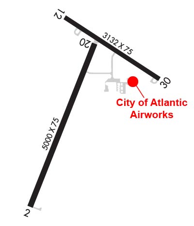
| Rwy | Rwy | |||||||
| 5000x75 | 5000' | 5000x75 | 5000' | |||||
| 3132x75 | 2842' | 3132x75 | 3132' | |||||
| Runway ID | Single Wheel | Double Wheel | Double Tandem Wheel | Dual Double Wheel |
| 02/20 | N/A | N/A | N/A | N/A |
| 12/30 | 12,500 | N/A | N/A | N/A |
| These numbers are Advisory and are not limits. The Airport Manager should have more accurate Weight Limits | ||||
 Airport Diagram might not be current. | |
| Facility Name: | ATLANTIC MUNI |
| City Name: | ATLANTIC |
| County: | CASS |
| State abbrev: | IA |
| State Name: | IOWA |
| Ownership: | PUBLICLY OWNED |
| Use: | OPEN TO THE PUBLIC |
| Owner's Name: | CITY OF ATLANTIC |
| Address: | 23 E. 4TH ST. |
| ATLANTIC, IA 50022 | |
| Owner's Phone: | 712-243-4810 |
| Manager's Name: | BARRY REID |
| Address: | 59706 AIRPORT RD; EMAIL ADDRESS: AIRWORKSAIO@GMAIL.COM (ALL LOWER CASE) |
| ATLANTIC, IA 50022 | |
| Phone: | 712-243-3056 |
| FAA Region: | CENTRAL |
| FAA Field Office: | NONE |
| Date | Sunrise | Sunset |
|---|---|---|
| 09/24/21 Friday | 7:09 | 19:14 |
| 09/25/21 Saturday | 7:10 | 19:13 |
| 09/26/21 Sunday | 7:11 | 19:11 |
| 09/27/21 Monday | 7:13 | 19:09 |
| 09/28/21 Tuesday | 7:14 | 19:07 |
| 09/29/21 Wednesday | 7:15 | 19:06 |
| 09/30/21 Thursday | 7:16 | 19:04 |
| 10/01/21 Friday | 7:17 | 19:02 |
| 10/02/21 Saturday | 7:18 | 19:01 |
| 10/03/21 Sunday | 7:19 | 18:59 |
| 10/04/21 Monday | 7:20 | 18:57 |
| 10/05/21 Tuesday | 7:21 | 18:56 |
| 10/06/21 Wednesday | 7:22 | 18:54 |
| 10/07/21 Thursday | 7:23 | 18:52 |
| Airport Attendance Schedule | MON-FRI 0800-1700, SAT 0800-1200; FOR SVC AFT HRS CALL 712-267-3263 |
| Airport Status | OPERATIONAL (This Status can change at any time - please check NOTAMS) |
| Airport Lighting Schedule | ACTVT MIRL RYS 02/20 & 12/30 AND REIL AND PAPI RYS 02/20- CTAF. |
| Airport Storage Available | Tie Downs, Hanger |
| Extra Services Available | Flight Instruction, Aircraft Rental, Aircraft Sales |
| Wind Indicator | YES - (lighted) |
| Control Tower | NO |
| CTAF Frequency | 122.700 |
| Unicom Frequency | 122.700 |
| Rotating Beacon Color | CLEAR-GREEN (Light Land Airport) |
| Segmented Circle | NO |
| Landing Fee | NO |
| Airport Inspected | STATE - performed by STATE AERONAUTICAL PERSONNEL |
| Inspection Date | 11/15/2019 |
| Type of Fuel Available | Grade 100LL, JET A (freeze point -40C) |
| Airframe Repair Service | MINOR |
| Power Plant Repair Service | MINOR |
| Latitude | N4124.2 |
| Longitude | W09502.9 (ESTIMATED) |
| Arpt Elevation | 1164ft (SURVEYED) |
| Magnetic Variation | 04E |
| 2 miles W | of ATLANTIC |
| Traffic Pattern Altitude | 800 |
| Sectional Chart | OMAHA |
| Operations (Reported) | Yearly | Avg. Daily |
|---|---|---|
| General Aviation Transient | 3078 | 8 |
| General Aviation Local | 4972 | 14 |
| Air Taxi | 0 | 0 |
| Commerical | 0 | 0 |
| Commuter | 0 | 0 |
| Military | 0 | 0 |
| Aircraft based on Field | |
|---|---|
| General Aviation Singles | 23 |
| General Aviation Multi | 3 |
| Jet Aircraft | 0 |
| General Aviation Helicopters | 0 |
| Military Aircraft | 0 |
| Gliders | 0 |
| Ultralights | 0 |
| FSS on field | NO |
| FSS tie-in | FORT DODGE |
| FSS Phone | 1-800-WX-BRIEF |
| Who issues Notams | AIO |
| Notam D service at airport | YES |
| ARTCC Name | MINNEAPOLIS |
| Airport Certification | |
| Aircraft Rescue & Firefighting Index | None |
| Airport of Entry | No |
| Custom Landing Rights | No |
| Joint Civil/Military | No |
| Military Landing rights | YES |
| NATIONAL PLAN OF INTEGRATED AIRPORT SYSTEMS (NPIAS) |
| GRANT AGREEMENT HAS EXPIRED; HOWEVER, AGREEMENT REMAINS IN EFFECT FOR THIS FACILITY AS LONG AS IT IS PUBLIC USE. |
| CREEK 200 FT FM RY END 30. |
| FOR CD CTC MINNEAPOLIS ARTCC AT 651-463-5588. |
Airport Communications & Frequencies:
| |||||||||
| Runway: 02 | Runway: 20 | ||
| Mag heading: | 18° | Mag heading: | 198° |
| Rwy Slope: | .06% Up | Rwy Slope: | -.06% Down |
| Approach: | Approach: | ||
| Pattern: | Left Traffic | Pattern: | Left Traffic |
| Markings: | NONPRECISION INSTRUMENT | Markings: | NONPRECISION INSTRUMENT |
| Marking Condition: | FAIR | Marking Condition: | FAIR |
| Arresting Dev: | Arresting Dev: | ||
| Lat & Long: | N4123.7 W09503.2 | Lat. & Long.: | N4124.5 W09502.8 |
| Elev: | 1145.9 ft. MSL | Elev: | 1149.0 ft. MSL |
| TCH: | 31 ft. AGL | TCH: | 31 ft. AGL |
| Visual Glide Path: | 3.00 degrees | Visual Glide Path: | 3.00 degrees |
| Displaced Threshold: | No | Displaced Threshold: | No |
| Touchdown Zone: | YES | Touchdown Zone: | YES |
| Touchdown Elev.: | 1150.8 feet | Touchdown Elev.: | 1151.2 feet |
| Visual Glide Slope: | 2-Light PAPI on LEFT side of Runway | Visual Glide Slope: | 2-Light PAPI on LEFT side of Runway |
| RVR Equipment: | RVR Equipment: | ||
| RVV Equipment: | NO | RVV Equipment: | NO |
| Approach Lights: | Approach Lights: | ||
| REIL: | YES | REIL: | YES |
| Centerline Lights: | NO | Centerline Lights: | NO |
| Touchdown lights: | NO | Touchdown lights: | NO |
| Runway Category: | Runway with a Non-precision Approach having visibility minimums greater than 3/4 mile | Runway Category: | Runway with a Non-precision Approach having visibility minimums greater than 3/4 mile |
| Declared Distances: | Declared Distances: |
| Runway: 12 | Runway: 30 | ||
| Mag heading: | 119° | Mag heading: | 299° |
| Rwy Slope: | -.67% Down | Rwy Slope: | .67% Up |
| Approach: | Approach: | ||
| Pattern: | Left Traffic | Pattern: | Left Traffic |
| Markings: | NONPRECISION INSTRUMENT | Markings: | NONPRECISION INSTRUMENT |
| Marking Condition: | FAIR | Marking Condition: | FAIR |
| Arresting Dev: | Arresting Dev: | ||
| Lat & Long: | N4124.6 W09503.0 | Lat. & Long.: | N4124.3 W09502.5 |
| Elev: | 1164.9 ft. MSL | Elev: | 1143.8 ft. MSL |
| TCH: | TCH: | ||
| Visual Glide Path: | Visual Glide Path: | ||
| Displaced Threshold: | 290 feet | Displaced Threshold: | No |
| Touchdown Zone: | YES | Touchdown Zone: | YES |
| Touchdown Elev.: | 1160.5 feet | Touchdown Elev.: | 1162.7 feet |
| Visual Glide Slope: | Visual Glide Slope: | ||
| RVR Equipment: | RVR Equipment: | ||
| RVV Equipment: | NO | RVV Equipment: | NO |
| Approach Lights: | Approach Lights: | ||
| REIL: | NO | REIL: | NO |
| Centerline Lights: | NO | Centerline Lights: | NO |
| Touchdown lights: | NO | Touchdown lights: | NO |
| Runway Category: | Runway with a Visual Approach | Runway Category: | Runway with a Visual Approach |
| Declared Distances: | TORA:3132' TODA:3132' ASDA:3132' LDA:2842' | Declared Distances: | TORA:3132' TODA:3132' ASDA:3132' LDA:3132' |
| Obstructions: | TREE | Obstructions: | BRUSH |
| Marked: | NOT Marked/Lighted | Marked: | NOT Marked/Lighted |
| Clearance slope: | 14:1; APCH SLOPE 20:1 TO DSPLCD THLD. | Clearance slope: | 20:1 |
| Obstruction height: | 73 feet AGL | Obstruction height: | 15 feet AGL |
| Dist. from runway: | 1287 feet | Dist. from runway: | 385 feet |
| Centerline offset: | 75 right of centerline | Centerline offset: | 110 feet right of centerline |
| Comments: | 13 FT ROAD @ 80 FT ON CNTRLN. | Comments: |
Thanks for using FltPlan.com
all rights reserved © 1999-2021 by Flight Plan LLC