
| ANDERSON MUNI-DARLINGTON FIELD ANDERSON IN |
| |
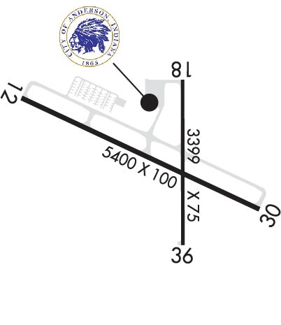
| Lat: N 4006.5 Long: W 08536.8 Elev: 919 Var: +03 Longest Runway: 5400 | ||
| AWOS: 128.55 Ground: 121.6 Tower: 126.0 | ||
| |||||||||||||||||||||||||||||||||||||||||||||||||||||||||||||||||||||
| |||||||||||||||||||||||||||||||||||||||||||||||||||||||||||||||||||||
| |||||||||||||||||||||||||||||||||||||||||||||||||||||||||||||||||||||
| Rwy | Rwy | |||||||
| 5400x100 | 5400' | 5400x100 | 5320' | 110.10 - 298° | ||||
| 3399x75 | 3108' | 3399x75 | 3111' | |||||
| Runway ID | Single Wheel | Double Wheel | Double Tandem Wheel | Dual Double Wheel |
| 12/30 | 45,000 | 55,000 | 85,000 | N/A |
| 18/36 | 10,000 | N/A | N/A | N/A |
| These numbers are Advisory and are not limits. The Airport Manager should have more accurate Weight Limits | ||||
 Airport Diagram might not be current. | |
| Facility Name: | ANDERSON MUNI-DARLINGTON FLD |
| City Name: | ANDERSON |
| County: | MADISON |
| State abbrev: | IN |
| State Name: | INDIANA |
| Ownership: | PUBLICLY OWNED |
| Use: | OPEN TO THE PUBLIC |
| Owner's Name: | CITY OF ANDERSON |
| Address: | 282 AIRPORT RD |
| ANDERSON, IN 46017 | |
| Owner's Phone: | 765-648-6293 |
| Manager's Name: | BRIAN MCMILLEN |
| Address: | 282 AIRPORT RD. |
| ANDERSON, IN 46017 | |
| Phone: | 765-648-6292 |
| FAA Region: | GREAT LAKES |
| FAA Field Office: | CHI |
| Date | Sunrise | Sunset |
|---|---|---|
| 09/24/21 Friday | 7:32 | 19:37 |
| 09/25/21 Saturday | 7:33 | 19:35 |
| 09/26/21 Sunday | 7:34 | 19:33 |
| 09/27/21 Monday | 7:35 | 19:32 |
| 09/28/21 Tuesday | 7:36 | 19:30 |
| 09/29/21 Wednesday | 7:37 | 19:28 |
| 09/30/21 Thursday | 7:38 | 19:27 |
| 10/01/21 Friday | 7:39 | 19:25 |
| 10/02/21 Saturday | 7:40 | 19:23 |
| 10/03/21 Sunday | 7:40 | 19:22 |
| 10/04/21 Monday | 7:41 | 19:20 |
| 10/05/21 Tuesday | 7:42 | 19:19 |
| 10/06/21 Wednesday | 7:44 | 19:17 |
| 10/07/21 Thursday | 7:45 | 19:15 |
| Airport Attendance Schedule | MON-FRI 0700-1800, SAT-SUN ON CALL; UNATNDD MARTIN LUTHER KING, PRES, ELECTION, EASTER, MEMORIAL, INDEPENDENCE, LABOR, VETERANS, THANKSGIVING, CHRISTMAS, NEW YEARS DAYS & GOOD FRIDAY; AFT HR - AMGR. |
| Airport Status | OPERATIONAL (This Status can change at any time - please check NOTAMS) |
| Airport Lighting Schedule | WHEN TWR CLSD ACTVT MALSF RWY 30; PAPI RWY 12 & 18; MIRL RWY 12/30 & 18/36 - CTAF. |
| Airport Storage Available | Tie Downs, Hanger |
| Extra Services Available | Air Freight, Charter, Flight Instruction, Aircraft Rental, Aircraft Sales |
| Wind Indicator | YES - (lighted) |
| Control Tower | YES |
| CTAF Frequency | 126.000 |
| Unicom Frequency | 122.950 |
| Rotating Beacon Color | CLEAR-GREEN (Light Land Airport) |
| Segmented Circle | YES |
| Landing Fee | NO |
| Airport Inspected | FEDERAL - performed by STATE AERONAUTICAL PERSONNEL |
| Inspection Date | 09/23/2019 |
| Type of Fuel Available | Grade 100LL, JET A (freeze point -40C)MOGAS |
| Airframe Repair Service | MAJOR |
| Power Plant Repair Service | MAJOR |
| Latitude | N4006.5 |
| Longitude | W08536.8 (ESTIMATED) |
| Arpt Elevation | 919ft (SURVEYED) |
| Magnetic Variation | 03W |
| 3 miles E | of ANDERSON |
| Traffic Pattern Altitude | |
| Sectional Chart | CHICAGO |
| Operations (Reported) | Yearly | Avg. Daily |
|---|---|---|
| General Aviation Transient | 8712 | 24 |
| General Aviation Local | 9292 | 25 |
| Air Taxi | 1162 | 3 |
| Commerical | 0 | 0 |
| Commuter | 0 | 0 |
| Military | 193 | 1 |
| Aircraft based on Field | |
|---|---|
| General Aviation Singles | 86 |
| General Aviation Multi | 12 |
| Jet Aircraft | 1 |
| General Aviation Helicopters | 3 |
| Military Aircraft | 0 |
| Gliders | 0 |
| Ultralights | 0 |
| FSS on field | NO |
| FSS tie-in | TERRE HAUTE |
| FSS Phone | 1-800-WX-BRIEF |
| Who issues Notams | AID |
| Notam D service at airport | YES |
| ARTCC Name | INDIANAPOLIS |
| Airport Certification | |
| Aircraft Rescue & Firefighting Index | None |
| Airport of Entry | No |
| Custom Landing Rights | No |
| Joint Civil/Military | No |
| Military Landing rights | YES |
| NATIONAL PLAN OF INTEGRATED AIRPORT SYSTEMS (NPIAS) |
| GRANT AGREEMENTS UNDER FAAP/ADAP/AIP |
| ASSURANCES PURSUANT TO TITLE VI, CIVIL RIGHTS ACT OF 1964 |
| DEP RWY 12, 18 & 36 UN TO SEE EACH OTHER. |
| DEER ON & INVOF ARPT. |
| TWY B CLSD INDEFLY. |
| WHEN ATCT IS CLSD FOR CD CTC INDIANAPOLIS APCH AT 317-227-5743. |
| GND COM OUTLET 121.725 COMMISSIONED KEY FREQ 4 TIMES. |
| TRML NOT STAFFED ON WKEND - AMGR. |
| SELF SERVE FUEL AVBL H24. |
| RWY 18/3 6 NOT AVBL TO ACR MORE THAN 30 PAX SEATS. |
Airport Communications & Frequencies:
| |||||||||||||||||||||
| Runway: 12 | Runway: 30 | ||
| Mag heading: | 118° | Mag heading: | 298° |
| Rwy Slope: | .72% Up | Rwy Slope: | -.72% Down |
| Approach: | Approach: | ILS | |
| Pattern: | Left Traffic | Pattern: | Left Traffic |
| Markings: | PRECISION INSTRUMENT | Markings: | PRECISION INSTRUMENT |
| Marking Condition: | GOOD | Marking Condition: | GOOD |
| Arresting Dev: | Arresting Dev: | ||
| Lat & Long: | N4006.7 W08537.4 | Lat. & Long.: | N4006.3 W08536.3 |
| Elev: | 880.1 ft. MSL | Elev: | 919.0 ft. MSL |
| TCH: | 45 ft. AGL | TCH: | 48 ft. AGL |
| Visual Glide Path: | 3.00 degrees | Visual Glide Path: | 3.00 degrees |
| Displaced Threshold: | No | Displaced Threshold: | 80 feet |
| Touchdown Zone: | YES | Touchdown Zone: | YES |
| Touchdown Elev.: | 896.9 feet | Touchdown Elev.: | 918.9 feet |
| Visual Glide Slope: | 4-Light PAPI on LEFT side of Runway | Visual Glide Slope: | 4-Light PAPI on LEFT side of Runway |
| RVR Equipment: | RVR Equipment: | ||
| RVV Equipment: | NO | RVV Equipment: | NO |
| Approach Lights: | Approach Lights: | MALSF - 1,400 foot medium intensity approach lighting system with sequenced flashers | |
| REIL: | YES | REIL: | NO |
| Centerline Lights: | NO | Centerline Lights: | NO |
| Touchdown lights: | NO | Touchdown lights: | NO |
| Runway Category: | Runway with a Visual Approach | Runway Category: | D |
| Declared Distances: | Declared Distances: | ||
| Obstructions: | TREES | Obstructions: | TREES |
| Marked: | NOT Marked/Lighted | Marked: | NOT Marked/Lighted |
| Clearance slope: | 13:1 | Clearance slope: | 30:1; APCH RATIO 35:1 TO DSPLCD THR. |
| Obstruction height: | 117 feet AGL | Obstruction height: | 50 feet AGL |
| Dist. from runway: | 1831 feet | Dist. from runway: | 1700 feet |
| Centerline offset: | 519 right of centerline | Centerline offset: | 30 feet right of centerline |
| Comments: | Comments: |
| Runway: 18 | Runway: 36 | ||
| Mag heading: | 183° | Mag heading: | 3° |
| Rwy Slope: | -.14% Down | Rwy Slope: | .14% Up |
| Approach: | Approach: | ||
| Pattern: | Left Traffic | Pattern: | Left Traffic |
| Markings: | BASIC | Markings: | BASIC |
| Marking Condition: | FAIR | Marking Condition: | FAIR |
| Arresting Dev: | Arresting Dev: | ||
| Lat & Long: | N4006.8 W08536.7 | Lat. & Long.: | N4006.2 W08536.7 |
| Elev: | 912.7 ft. MSL | Elev: | 908.0 ft. MSL |
| TCH: | 30 ft. AGL | TCH: | |
| Visual Glide Path: | 3.00 degrees | Visual Glide Path: | |
| Displaced Threshold: | 291 feet | Displaced Threshold: | 288 feet |
| Touchdown Zone: | YES | Touchdown Zone: | YES |
| Touchdown Elev.: | 912.2 feet | Touchdown Elev.: | 912.5 feet |
| Visual Glide Slope: | 2-Light PAPI on LEFT side of Runway | Visual Glide Slope: | |
| RVR Equipment: | RVR Equipment: | ||
| RVV Equipment: | NO | RVV Equipment: | NO |
| Approach Lights: | Approach Lights: | ||
| REIL: | NO | REIL: | NO |
| Centerline Lights: | NO | Centerline Lights: | NO |
| Touchdown lights: | NO | Touchdown lights: | NO |
| Runway Category: | Runway with a Visual Approach | Runway Category: | Runway with a Visual Approach |
| Declared Distances: | Declared Distances: | ||
| Obstructions: | TREE | Obstructions: | TREES |
| Marked: | NOT Marked/Lighted | Marked: | NOT Marked/Lighted |
| Clearance slope: | 17:1; APCH RATIO 24:1 TO DSPLCD THR. | Clearance slope: | 17:1; APCH RATIO 22:1 TO DSPLCD THR. |
| Obstruction height: | 73 feet AGL | Obstruction height: | 98 feet AGL |
| Dist. from runway: | 1463 feet | Dist. from runway: | 1900 feet |
| Centerline offset: | 134 right of centerline | Centerline offset: | 100 feet left of centerline |
| Comments: | 11 FT RD 170 FT FM RWY END. | Comments: |
Thanks for using FltPlan.com
all rights reserved © 1999-2021 by Flight Plan LLC


