
| HOPKINS FIELD NUCLA CO |
| |
| Lat: N 3814.3 Long: W 10833.8 Elev: 5945 Var: -11 Longest Runway: 5212 | ||
| AWOS: 132.52 CTAF: 122.8 | ||
| ||||||||||||||||||||||||||||||||||||||||||||
| ||||||||||||||||||||||||||||||||||||||||||||
| ||||||||||||||||||||||||||||||||||||||||||||
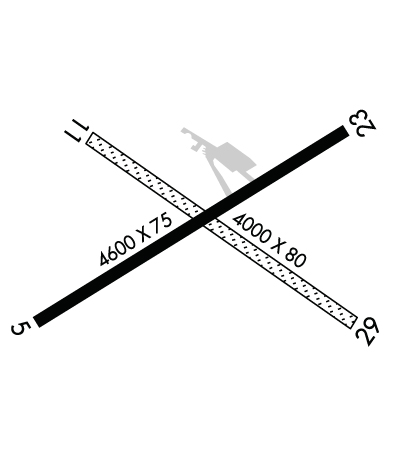
| Rwy | Rwy | |||||||
| 5212x75 | 5212' | 5212x75 | 5212' | |||||
| 4000x80 | 4000' | 4000x80 | 4000' | |||||
| Runway ID | Single Wheel | Double Wheel | Double Tandem Wheel | Dual Double Wheel |
| 05/23 | 9,000 | N/A | N/A | N/A |
| 11/29 | N/A | N/A | N/A | N/A |
| These numbers are Advisory and are not limits. The Airport Manager should have more accurate Weight Limits | ||||
 Airport Diagram might not be current. | |
| Facility Name: | HOPKINS FLD |
| City Name: | NUCLA |
| County: | MONTROSE |
| State abbrev: | CO |
| State Name: | COLORADO |
| Ownership: | PUBLICLY OWNED |
| Use: | OPEN TO THE PUBLIC |
| Owner's Name: | COUNTY OF MONTROSE |
| Address: | BOX 997 |
| MONTROSE, CO 81401 | |
| Owner's Phone: | 970-249-3203 |
| Manager's Name: | LLOYD ARNOLD |
| Address: | BOX 58 |
| NUCLA, CO 81424 | |
| Phone: | 970-864-7111 |
| FAA Region: | NORTHWEST MOUNTAIN |
| FAA Field Office: | DEN |
| Date | Sunrise | Sunset |
|---|---|---|
| 06/07/26 Sunday | 5:51 | 20:35 |
| 06/08/26 Monday | 5:51 | 20:36 |
| 06/09/26 Tuesday | 5:51 | 20:36 |
| 06/10/26 Wednesday | 5:50 | 20:37 |
| 06/11/26 Thursday | 5:50 | 20:37 |
| 06/12/26 Friday | 5:50 | 20:38 |
| 06/13/26 Saturday | 5:50 | 20:38 |
| 06/14/26 Sunday | 5:50 | 20:39 |
| 06/15/26 Monday | 5:50 | 20:39 |
| 06/16/26 Tuesday | 5:50 | 20:40 |
| 06/17/26 Wednesday | 5:50 | 20:40 |
| 06/18/26 Thursday | 5:51 | 20:40 |
| 06/19/26 Friday | 5:51 | 20:40 |
| 06/20/26 Saturday | 5:51 | 20:41 |
| Airport Attendance Schedule | UNATTENDED |
| Airport Status | OPERATIONAL (This Status can change at any time - please check NOTAMS) |
| Airport Lighting Schedule | REIL RWY 05 & 23; MIRL RWY 5/23 - DUSK-DAWN, INCR INTST - CTAF. PAPI RWY 05 & 23 ON CONSLY. |
| Airport Storage Available | Tie Downs |
| Extra Services Available | NONE |
| Wind Indicator | YES - (lighted) |
| Control Tower | NO |
| CTAF Frequency | 122.800 |
| Unicom Frequency | 122.800 |
| Rotating Beacon Color | WG |
| Segmented Circle | YES |
| Landing Fee | NO |
| Airport Inspected | STATE - performed by STATE AERONAUTICAL PERSONNEL |
| Inspection Date | 05/24/2024 |
| Type of Fuel Available | Grade 100LL, JET A (freeze point -40C); -10FUEL SELF-SERVICE AVBL 24 HRS. |
| Airframe Repair Service | None |
| Power Plant Repair Service | None |
| Latitude | N3814.3 |
| Longitude | W10833.8 (ESTIMATED) |
| Arpt Elevation | 5945ft (SURVEYED) |
| Magnetic Variation | 11E |
| 2 miles SW | of NUCLA |
| Traffic Pattern Altitude | |
| Sectional Chart | DENVER |
| Operations (Reported) | Yearly | Avg. Daily |
|---|---|---|
| General Aviation Transient | 0 | 0 |
| General Aviation Local | 0 | 0 |
| Air Taxi | 0 | 0 |
| Commerical | 0 | 0 |
| Commuter | 0 | 0 |
| Military | 0 | 0 |
| Aircraft based on Field | |
|---|---|
| General Aviation Singles | 0 |
| General Aviation Multi | 0 |
| Jet Aircraft | 0 |
| General Aviation Helicopters | 0 |
| Military Aircraft | 0 |
| Gliders | 0 |
| Ultralights | 0 |
| FSS on field | NO |
| FSS tie-in | DENVER |
| FSS Phone | 1-800-WX-BRIEF |
| Who issues Notams | DEN |
| Notam D service at airport | YES |
| ARTCC Name | DENVER |
| Airport Certification | |
| Aircraft Rescue & Firefighting Index | None |
| Airport of Entry | No |
| Custom Landing Rights | No |
| Joint Civil/Military | No |
| Military Landing rights | YES |
| NATIONAL PLAN OF INTEGRATED AIRPORT SYSTEMS (NPIAS) |
| CONVEYANCE UNDER SCETION 16, FEDERAL AIRPORT ACT OF 1946 OR SECTION 23, AIRPORT AND AIRWAY DEVELOPMENT ACT OF 1970 |
| GRANT AGREEMENT HAS EXPIRED; HOWEVER, AGREEMENT REMAINS IN EFFECT FOR THIS FACILITY AS LONG AS IT IS PUBLIC USE. |
| 40 FT PLINES IN HANGAR AREA. |
| MIGTATORY BIRDS, WILDLIFE & DEER ON OR INVOF ARPT. |
| FOR CD CTC DENVER ARTCC AT 303-651-4257. |
| RWY 11/2 9 MULT LRG RODENT HOLES. |
Airport Communications & Frequencies:
| |||||||||
| Runway: 05 | Runway: 23 | ||
| Mag heading: | 48° | Mag heading: | 228° |
| Rwy Slope: | .90% Up | Rwy Slope: | -.90% Down |
| Approach: | Approach: | ||
| Pattern: | Left Traffic | Pattern: | Left Traffic |
| Markings: | NONPRECISION INSTRUMENT | Markings: | NONPRECISION INSTRUMENT |
| Marking Condition: | FAIR | Marking Condition: | GOOD |
| Arresting Dev: | Arresting Dev: | ||
| Lat & Long: | N3814.1 W10834.2 | Lat. & Long.: | N3814.6 W10833.3 |
| Elev: | 5898.1 ft. MSL | Elev: | 5945.1 ft. MSL |
| TCH: | 41 ft. AGL | TCH: | 41 ft. AGL |
| Visual Glide Path: | 3.00 degrees | Visual Glide Path: | 3.00 degrees |
| Displaced Threshold: | No | Displaced Threshold: | No |
| Touchdown Zone: | YES | Touchdown Zone: | YES |
| Touchdown Elev.: | 5923.9 feet | Touchdown Elev.: | 5945.1 feet |
| Visual Glide Slope: | 2-Light PAPI on LEFT side of Runway; PAPI UNUSBL BYD 5.0 NM. | Visual Glide Slope: | 2-Light PAPI on LEFT side of Runway |
| RVR Equipment: | RVR Equipment: | ||
| RVV Equipment: | NO | RVV Equipment: | NO |
| Approach Lights: | Approach Lights: | ||
| REIL: | YES | REIL: | YES |
| Centerline Lights: | NO | Centerline Lights: | NO |
| Touchdown lights: | NO | Touchdown lights: | NO |
| Runway Category: | Runway with a Visual Approach | Runway Category: | Runway with a Visual Approach |
| Declared Distances: | Declared Distances: | ||
| Obstructions: | Obstructions: | ROAD | |
| Marked: | Marked: | NOT Marked/Lighted | |
| Clearance slope: | 50:1 | Clearance slope: | 20:1 |
| Obstruction height: | Obstruction height: | 18 feet AGL | |
| Dist. from runway: | Dist. from runway: | 570 feet | |
| Centerline offset: | Centerline offset: | ||
| Comments: | Comments: |
| Runway: 11 | Runway: 29 | ||
| Mag heading: | 113° | Mag heading: | 293° |
| Rwy Slope: | .77% Up | Rwy Slope: | -.77% Down |
| Approach: | Approach: | ||
| Pattern: | Left Traffic | Pattern: | Left Traffic |
| Markings: | NONSTANDARD | Markings: | NONSTANDARD |
| Marking Condition: | GOOD | Marking Condition: | GOOD |
| Arresting Dev: | Arresting Dev: | ||
| Lat & Long: | N3814.5 W10834.1 | Lat. & Long.: | N3814.1 W10833.4 |
| Elev: | 5899.4 ft. MSL | Elev: | 5930.0 ft. MSL |
| TCH: | TCH: | ||
| Visual Glide Path: | Visual Glide Path: | ||
| Displaced Threshold: | No | Displaced Threshold: | No |
| Touchdown Zone: | YES | Touchdown Zone: | YES |
| Touchdown Elev.: | 5927.5 feet | Touchdown Elev.: | 5933.4 feet |
| Visual Glide Slope: | Visual Glide Slope: | ||
| RVR Equipment: | RVR Equipment: | ||
| RVV Equipment: | NO | RVV Equipment: | NO |
| Approach Lights: | Approach Lights: | ||
| REIL: | NO | REIL: | NO |
| Centerline Lights: | NO | Centerline Lights: | NO |
| Touchdown lights: | NO | Touchdown lights: | NO |
| Runway Category: | Runway with a Visual Approach | Runway Category: | Runway with a Visual Approach |
| Declared Distances: | Declared Distances: | ||
| Obstructions: | ROAD | Obstructions: | FENCE |
| Marked: | NOT Marked/Lighted | Marked: | NOT Marked/Lighted |
| Clearance slope: | 16:1 | Clearance slope: | 18:1 |
| Obstruction height: | 6 feet AGL | Obstruction height: | 3 feet AGL |
| Dist. from runway: | 100 feet | Dist. from runway: | 56 feet |
| Centerline offset: | Centerline offset: | ||
| Comments: | Comments: |
Thanks for using FltPlan.com
all rights reserved © 1999-2026 by Flight Plan LLC
