
| ALLIANCE MUNI ALLIANCE NE |
| |
| Lat: N 4203.2 Long: W 10248.2 Elev: 3931 Var: -07 Longest Runway: 9203 | ||
| AWOS: 135.07 CTAF: 123.0 | ||
| ||||||||||||||||||||||||||||||||||||||||||||
| ||||||||||||||||||||||||||||||||||||||||||||
| ||||||||||||||||||||||||||||||||||||||||||||
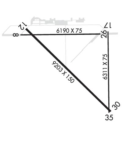
| Rwy | Rwy | |||||||
| 6190x75 | 6190' | 6190x75 | 6190' | |||||
| 9203x150 | 9203' | 9203x150 | 9203' | 108.35 - 307° | ||||
| 6311x75 | 6311' | 6311x75 | 6311' | |||||
| Runway ID | Single Wheel | Double Wheel | Double Tandem Wheel | Dual Double Wheel |
| 08/26 | 36,000 | 48,000 | 80,000 | N/A |
| 12/30 | 36,000 | 48,000 | 80,000 | N/A |
| 17/35 | 24,000 | 30,000 | N/A | N/A |
| These numbers are Advisory and are not limits. The Airport Manager should have more accurate Weight Limits | ||||
 Airport Diagram might not be current. | |
| Facility Name: | ALLIANCE MUNI |
| City Name: | ALLIANCE |
| County: | BOX BUTTE |
| State abbrev: | NE |
| State Name: | NEBRASKA |
| Ownership: | PUBLICLY OWNED |
| Use: | OPEN TO THE PUBLIC |
| Owner's Name: | CITY OF ALLIANCE |
| Address: | PO BOX D |
| ALLIANCE, NE 69301 | |
| Owner's Phone: | 308-762-5400 |
| Manager's Name: | MS LYNN PLACEK |
| Address: | 5631 SARPY ROAD, PO BOX D |
| ALLIANCE, NE 69301 | |
| Phone: | 308-762-4512 |
| FAA Region: | CENTRAL |
| FAA Field Office: | NONE |
| Date | Sunrise | Sunset |
|---|---|---|
| 09/24/21 Friday | 6:40 | 18:45 |
| 09/25/21 Saturday | 6:42 | 18:44 |
| 09/26/21 Sunday | 6:43 | 18:42 |
| 09/27/21 Monday | 6:44 | 18:40 |
| 09/28/21 Tuesday | 6:45 | 18:38 |
| 09/29/21 Wednesday | 6:46 | 18:37 |
| 09/30/21 Thursday | 6:47 | 18:35 |
| 10/01/21 Friday | 6:48 | 18:33 |
| 10/02/21 Saturday | 6:49 | 18:31 |
| 10/03/21 Sunday | 6:50 | 18:30 |
| 10/04/21 Monday | 6:51 | 18:28 |
| 10/05/21 Tuesday | 6:52 | 18:26 |
| 10/06/21 Wednesday | 6:53 | 18:25 |
| 10/07/21 Thursday | 6:55 | 18:23 |
| Airport Attendance Schedule | CONTINUOUS |
| Airport Status | OPERATIONAL (This Status can change at any time - please check NOTAMS) |
| Airport Lighting Schedule | ACTVT MALSR RWY 30; REIL RWY 12; VASI RWY 12; PAPI RWY 30 & MIRL RWY 12/30 & 08/26 -CTAF. |
| Airport Storage Available | Tie Downs, Hanger |
| Extra Services Available | Crop Dusting, Flight Instruction, Aircraft Rental, Aircraft Sales |
| Wind Indicator | YES - (lighted) |
| Control Tower | NO |
| CTAF Frequency | 123.000 |
| Unicom Frequency | 123.000 |
| Rotating Beacon Color | CLEAR-GREEN (Light Land Airport) |
| Segmented Circle | YES |
| Landing Fee | NO |
| Airport Inspected | FEDERAL - performed by FAA AIRPORTS FIELD PERSONNEL |
| Inspection Date | 07/16/2019 |
| Type of Fuel Available | Grade 100LL, JET A (freeze point -40C) |
| Airframe Repair Service | MAJOR |
| Power Plant Repair Service | MAJOR |
| Latitude | N4203.2 |
| Longitude | W10248.2 (ESTIMATED) |
| Arpt Elevation | 3930ft (SURVEYED) |
| Magnetic Variation | 07E |
| 3 miles SE | of ALLIANCE |
| Traffic Pattern Altitude | |
| Sectional Chart | CHEYENNE |
| Operations (Reported) | Yearly | Avg. Daily |
|---|---|---|
| General Aviation Transient | 3103 | 9 |
| General Aviation Local | 8608 | 24 |
| Air Taxi | 110 | 0 |
| Commerical | 1252 | 3 |
| Commuter | 0 | 0 |
| Military | 2 | 0 |
| Aircraft based on Field | |
|---|---|
| General Aviation Singles | 44 |
| General Aviation Multi | 2 |
| Jet Aircraft | 0 |
| General Aviation Helicopters | 0 |
| Military Aircraft | 0 |
| Gliders | 1 |
| Ultralights | 0 |
| FSS on field | NO |
| FSS tie-in | COLUMBUS |
| FSS Phone | 1-800-WX-BRIEF |
| Who issues Notams | AIA |
| Notam D service at airport | YES |
| ARTCC Name | DENVER |
| Airport Certification | AIRPORT RECEIVING SCHEDULED AIR CARRIER SERVICE FROM CARRIERS CERTIFICATED BY THE CIVIL AERONAUTICS BOARD; RWY 17/35 NOT AVBL FOR SKED ACR OPNS WITH MORE THAN 9 PSGR SEATS OR UNSKED ACR AT LEAST 31 PSGR SEATS. |
| Aircraft Rescue & Firefighting Index | AIRPORT HAS A CERTIFICATE UNDER CFR PART 139 |
| Airport of Entry | No |
| Custom Landing Rights | No |
| Joint Civil/Military | No |
| Military Landing rights | YES |
| NATIONAL PLAN OF INTEGRATED AIRPORT SYSTEMS (NPIAS) |
| GRANT AGREEMENTS UNDER FAAP/ADAP/AIP |
| SURPLUS PROPERTY AGREEMENT UNDER PUBLIC LAW 289 |
| ASSURANCES PURSUANT TO TITLE VI, CIVIL RIGHTS ACT OF 1964 |
| RY 17/35 UNAVBL FOR USE BY AIR CARRIERS. |
| FOR CD IF UNA TO CTC ON FSS FREQ, CTC DENVER ARTCC AT 303-651-4257. |
| ULTRALIGHT & GLIDER OPNS ON & INVOF ARPT. |
| AERIAL SPRAYING OPNS ON & INVOF ARPT. |
| RY 08/26 DESIGNATED CALM WIND. |
| HAYING OPNS ON INTERIOR OF ARPT DURG SUMMER MONTHS. |
| OCCASIONAL USE BY ACFT WITH NO RADIO. |
| BACK TAXIING. |
| MIGRATORY WATERFOWL ON & INVOF ARPT. |
Airport Communications & Frequencies:
| |||||||||
| Runway: 08 | Runway: 26 | ||
| Mag heading: | 82° | Mag heading: | 262° |
| Rwy Slope: | -.09% Down | Rwy Slope: | .09% Up |
| Approach: | Approach: | ||
| Pattern: | Left Traffic | Pattern: | Left Traffic |
| Markings: | NONPRECISION INSTRUMENT | Markings: | NONPRECISION INSTRUMENT |
| Marking Condition: | GOOD | Marking Condition: | GOOD |
| Arresting Dev: | Arresting Dev: | ||
| Lat & Long: | N4203.5 W10249.2 | Lat. & Long.: | N4203.5 W10247.8 |
| Elev: | 3930.6 ft. MSL | Elev: | 3924.9 ft. MSL |
| TCH: | TCH: | ||
| Visual Glide Path: | Visual Glide Path: | ||
| Displaced Threshold: | No | Displaced Threshold: | No |
| Touchdown Zone: | YES | Touchdown Zone: | YES |
| Touchdown Elev.: | 3930.6 feet | Touchdown Elev.: | 3926.8 feet |
| Visual Glide Slope: | Visual Glide Slope: | ||
| RVR Equipment: | RVR Equipment: | ||
| RVV Equipment: | NO | RVV Equipment: | NO |
| Approach Lights: | Approach Lights: | ||
| REIL: | NO | REIL: | NO |
| Centerline Lights: | NO | Centerline Lights: | NO |
| Touchdown lights: | NO | Touchdown lights: | NO |
| Runway Category: | Runway with a Non-precision Approach having visibility minimums greater than 3/4 mile | Runway Category: | Runway with a Non-precision Approach having visibility minimums greater than 3/4 mile |
| Declared Distances: | TORA:6190' TODA:6190' ASDA:6190' LDA:6190' | Declared Distances: | TORA:6200' TODA:6200' ASDA:6200' LDA:6200' |
| Runway: 12 | Runway: 30 | ||
| Mag heading: | 127° | Mag heading: | 307° |
| Rwy Slope: | -.06% Down | Rwy Slope: | .06% Up |
| Approach: | Approach: | ILS/DME | |
| Pattern: | Left Traffic | Pattern: | Left Traffic |
| Markings: | NONPRECISION INSTRUMENT | Markings: | PRECISION INSTRUMENT |
| Marking Condition: | GOOD | Marking Condition: | GOOD |
| Arresting Dev: | Arresting Dev: | ||
| Lat & Long: | N4203.6 W10249.1 | Lat. & Long.: | N4202.5 W10247.7 |
| Elev: | 3929.8 ft. MSL | Elev: | 3924.5 ft. MSL |
| TCH: | 39 ft. AGL | TCH: | 53 ft. AGL |
| Visual Glide Path: | 3.00 degrees | Visual Glide Path: | 3.00 degrees |
| Displaced Threshold: | No | Displaced Threshold: | No |
| Touchdown Zone: | YES | Touchdown Zone: | YES |
| Touchdown Elev.: | 3930.2 feet | Touchdown Elev.: | 3927.2 feet |
| Visual Glide Slope: | 4-BOX VASI ON LEFT SIDE OF RUNWAY | Visual Glide Slope: | 4-Light PAPI on LEFT side of Runway |
| RVR Equipment: | RVR Equipment: | ||
| RVV Equipment: | NO | RVV Equipment: | NO |
| Approach Lights: | Approach Lights: | MALSR - 1,400 foot medium intensity approach lighting system with runway alignment indicator lights | |
| REIL: | YES | REIL: | NO |
| Centerline Lights: | NO | Centerline Lights: | NO |
| Touchdown lights: | NO | Touchdown lights: | NO |
| Runway Category: | Runway with a Non-precision Approach having visibility minimums greater than 3/4 mile | Runway Category: | Precision Instrument Runway |
| Declared Distances: | TORA:9202' TODA:9202' ASDA:9202' LDA:9202' | Declared Distances: | TORA:9202' TODA:9202' ASDA:9202' LDA:9202' |
| Runway: 17 | Runway: 35 | ||
| Mag heading: | 172° | Mag heading: | 352° |
| Rwy Slope: | .01% Up | Rwy Slope: | -.01% Down |
| Approach: | Approach: | ||
| Pattern: | Left Traffic | Pattern: | Left Traffic |
| Markings: | BASIC | Markings: | BASIC |
| Marking Condition: | FAIR | Marking Condition: | FAIR |
| Arresting Dev: | Arresting Dev: | ||
| Lat & Long: | N4203.6 W10247.7 | Lat. & Long.: | N4202.5 W10247.7 |
| Elev: | 3924.6 ft. MSL | Elev: | 3925.2 ft. MSL |
| TCH: | TCH: | ||
| Visual Glide Path: | Visual Glide Path: | ||
| Displaced Threshold: | No | Displaced Threshold: | No |
| Touchdown Zone: | YES | Touchdown Zone: | YES |
| Touchdown Elev.: | 3925.0 feet | Touchdown Elev.: | 3925.2 feet |
| Visual Glide Slope: | Visual Glide Slope: | ||
| RVR Equipment: | RVR Equipment: | ||
| RVV Equipment: | NO | RVV Equipment: | NO |
| Approach Lights: | Approach Lights: | ||
| REIL: | NO | REIL: | NO |
| Centerline Lights: | NO | Centerline Lights: | NO |
| Touchdown lights: | NO | Touchdown lights: | NO |
| Runway Category: | Runway with a Visual Approach | Runway Category: | Runway with a Visual Approach |
| Declared Distances: | TORA:6311' TODA:6311' ASDA:6311' LDA:6311' | Declared Distances: | TORA:6311' TODA:6311' ASDA:6311' LDA:6311' |
Thanks for using FltPlan.com
all rights reserved © 1999-2021 by Flight Plan LLC
