| ANSON COUNTY WADESBORO NC |
| |
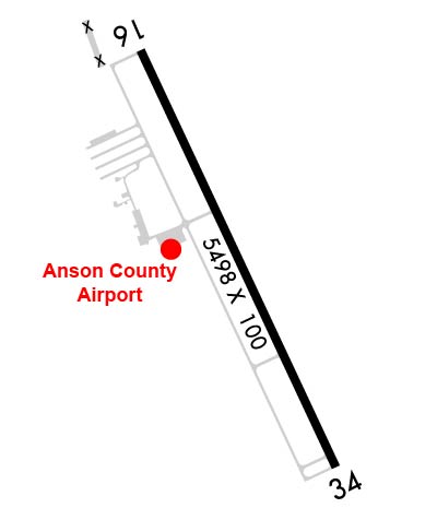
| Lat: N 3501.2 Long: W 08004.6 Elev: 300 Var: +07 Longest Runway: 5498 | ||
| AWOS: 119.32 CTAF: 122.8 | ||
| |||||||||||||||||||||||||||||||||||||||||||||||||||||||||||||
| |||||||||||||||||||||||||||||||||||||||||||||||||||||||||||||
| |||||||||||||||||||||||||||||||||||||||||||||||||||||||||||||
| Rwy | Rwy | |||||||
| 5498x100 | 5498' | 5498x100 | 5498' | 108.55 - 341° | ||||
| Runway ID | Single Wheel | Double Wheel | Double Tandem Wheel | Dual Double Wheel |
| 16/34 | 12,000 | 60,000 | N/A | N/A |
| These numbers are Advisory and are not limits. The Airport Manager should have more accurate Weight Limits | ||||
 Airport Diagram might not be current. | |
| Facility Name: | ANSON COUNTY/JEFF CLOUD FLD |
| City Name: | WADESBORO |
| County: | ANSON |
| State abbrev: | NC |
| State Name: | NORTH CAROLINA |
| Ownership: | PUBLICLY OWNED |
| Use: | OPEN TO THE PUBLIC |
| Owner's Name: | ANSON COUNTY |
| Address: | 101 S. GREENE STREET |
| WADESBORO, NC 28170 | |
| Owner's Phone: | 704-994-3200 |
| Manager's Name: | REX EDWARDS |
| Address: | 2980 AIRPORT ROAD |
| WADESBORO, NC 28170 | |
| Phone: | (704) 389-0633 |
| FAA Region: | SOUTHERN |
| FAA Field Office: | MEM |
| Date | Sunrise | Sunset |
|---|---|---|
| 06/12/26 Friday | 6:06 | 20:35 |
| 06/13/26 Saturday | 6:06 | 20:35 |
| 06/14/26 Sunday | 6:06 | 20:35 |
| 06/15/26 Monday | 6:06 | 20:36 |
| 06/16/26 Tuesday | 6:06 | 20:36 |
| 06/17/26 Wednesday | 6:06 | 20:36 |
| 06/18/26 Thursday | 6:06 | 20:37 |
| 06/19/26 Friday | 6:06 | 20:37 |
| 06/20/26 Saturday | 6:06 | 20:37 |
| 06/21/26 Sunday | 6:07 | 20:38 |
| 06/22/26 Monday | 6:07 | 20:38 |
| 06/23/26 Tuesday | 6:07 | 20:38 |
| 06/24/26 Wednesday | 6:07 | 20:38 |
| 06/25/26 Thursday | 6:08 | 20:38 |
| Airport Attendance Schedule | MON-FRI 0830-1700; FOR AFT HRS SVC CALL 704-389-0633. |
| Airport Status | OPERATIONAL (This Status can change at any time - please check NOTAMS) |
| Airport Lighting Schedule | ACTVT REILS RWY 16 & 34; PAPI RWY 16 & 34; MIRL RWY 16/34 - CTAF. |
| Airport Storage Available | Tie Downs |
| Extra Services Available | NONE |
| Wind Indicator | YES - (lighted) |
| Control Tower | NO |
| CTAF Frequency | 122.800 |
| Unicom Frequency | 122.800 |
| Rotating Beacon Color | WG |
| Segmented Circle | YES |
| Landing Fee | NO |
| Airport Inspected | STATE - performed by STATE AERONAUTICAL PERSONNEL |
| Inspection Date | 05/29/2023 |
| Type of Fuel Available | Grade 100LL, JET A-1 (icing inhibitor, freeze point -50C); -10100LL FUEL - 24 HR SELF SVC AVBL WITH CREDIT CARD.; -A1FOR JET-A AFT HRS CALL FBO DURG OFC HRS FOR PRE-ARNGMT. |
| Airframe Repair Service | NONE |
| Power Plant Repair Service | NONE |
| Latitude | N3501.2 |
| Longitude | W08004.6 (ESTIMATED) |
| Arpt Elevation | 299ft (SURVEYED) |
| Magnetic Variation | 07W |
| 3 miles N | of WADESBORO |
| Traffic Pattern Altitude | |
| Sectional Chart | CHARLOTTE |
| Operations (Reported) | Yearly | Avg. Daily |
|---|---|---|
| General Aviation Transient | 0 | 0 |
| General Aviation Local | 0 | 0 |
| Air Taxi | 0 | 0 |
| Commerical | 0 | 0 |
| Commuter | 0 | 0 |
| Military | 0 | 0 |
| Aircraft based on Field | |
|---|---|
| General Aviation Singles | 0 |
| General Aviation Multi | 0 |
| Jet Aircraft | 0 |
| General Aviation Helicopters | 0 |
| Military Aircraft | 0 |
| Gliders | 0 |
| Ultralights | 0 |
| FSS on field | NO |
| FSS tie-in | RALEIGH |
| FSS Phone | 1-800-WX-BRIEF |
| Who issues Notams | RDU |
| Notam D service at airport | YES |
| ARTCC Name | ATLANTA |
| Airport Certification | |
| Aircraft Rescue & Firefighting Index | None |
| Airport of Entry | No |
| Custom Landing Rights | No |
| Joint Civil/Military | No |
| Military Landing rights | No |
| NATIONAL PLAN OF INTEGRATED AIRPORT SYSTEMS (NPIAS) |
| DEER IN VICINITY OF ARPT. |
| FOR CD CTC CHARLOTTE APCH AT 704-359-0241. |
| RWY 34 HAS 60+ FT UNMARKED POWER LINES 2700 FT FM THR BOTH SIDES OF CNTRLN. |
Airport Communications & Frequencies:
| ||||||||||||||
| Runway: 16 | Runway: 34 | ||
| Mag heading: | 162° | Mag heading: | 342° |
| Rwy Slope: | -.05% Down | Rwy Slope: | .05% Up |
| Approach: | Approach: | ILS/DME | |
| Pattern: | Left Traffic | Pattern: | Left Traffic |
| Markings: | NONPRECISION INSTRUMENT | Markings: | PRECISION INSTRUMENT |
| Marking Condition: | GOOD | Marking Condition: | GOOD |
| Arresting Dev: | Arresting Dev: | ||
| Lat & Long: | N3501.6 W08004.9 | Lat. & Long.: | N3500.8 W08004.4 |
| Elev: | 299.3 ft. MSL | Elev: | 296.8 ft. MSL |
| TCH: | 44 ft. AGL | TCH: | 45 ft. AGL |
| Visual Glide Path: | 3.00 degrees | Visual Glide Path: | 3.00 degrees |
| Displaced Threshold: | No | Displaced Threshold: | No |
| Touchdown Zone: | YES | Touchdown Zone: | YES |
| Touchdown Elev.: | 299.7 feet | Touchdown Elev.: | 299.3 feet |
| Visual Glide Slope: | 4-Light PAPI on LEFT side of Runway | Visual Glide Slope: | 4-Light PAPI on LEFT side of Runway |
| RVR Equipment: | RVR Equipment: | ||
| RVV Equipment: | NO | RVV Equipment: | NO |
| Approach Lights: | Approach Lights: | ||
| REIL: | YES | REIL: | YES |
| Centerline Lights: | NO | Centerline Lights: | NO |
| Touchdown lights: | NO | Touchdown lights: | NO |
| Runway Category: | Runway with a Non-precision Approach having visibility minimums greater than 3/4 mile | Runway Category: | Precision Instrument Runway |
| Declared Distances: | Declared Distances: | ||
| Obstructions: | TREES | Obstructions: | TREES |
| Marked: | NOT Marked/Lighted | Marked: | NOT Marked/Lighted |
| Clearance slope: | 14:1 | Clearance slope: | 16:1 |
| Obstruction height: | 83 feet AGL | Obstruction height: | 23 feet AGL |
| Dist. from runway: | 1426 feet | Dist. from runway: | 579 feet |
| Centerline offset: | 221 right of centerline | Centerline offset: | 356 feet right of centerline |
| Comments: | 14 FT TREES 139 FT FROM END OF RWY AND OFFSET 308 FT RIGHT OF CNTRLN. | Comments: | 17 FT HILL 0-200 FT FROM END OF RWY AND 364 FT LEFT OF CNTRLN. |
Thanks for using FltPlan.com
all rights reserved © 1999-2026 by Flight Plan LLC