
| JAFFREY AIRPORT-SILVER RANCH JAFFREY NH |
| |
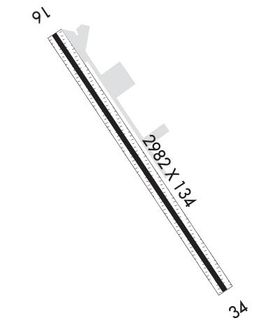
| Lat: N 4248.3 Long: W 07200.2 Elev: 1040 Var: +14 Longest Runway: 2982 | ||
| AWOS: 135.87 CTAF: 122.8 | ||
| ||||||||||||||||||||||||||||||||||||||||||||
| ||||||||||||||||||||||||||||||||||||||||||||
| ||||||||||||||||||||||||||||||||||||||||||||
| Rwy | Rwy | |||||||
| 2982x134 | 2982' | 2982x134 | 2400' | |||||
| Runway ID | Single Wheel | Double Wheel | Double Tandem Wheel | Dual Double Wheel |
| 16/34 | 8,000 | N/A | N/A | N/A |
| These numbers are Advisory and are not limits. The Airport Manager should have more accurate Weight Limits | ||||
 Airport Diagram might not be current. | |
| Facility Name: | JAFFREY AIRFIELD SILVER RANCH |
| City Name: | JAFFREY |
| County: | CHESHIRE |
| State abbrev: | NH |
| State Name: | NEW HAMPSHIRE |
| Ownership: | PRIVATELY OWNED |
| Use: | OPEN TO THE PUBLIC |
| Owner's Name: | JAFFREY MUNI ARPT DEV CORP |
| Address: | 190 TURNPIKE RD, JAFFREY AIRFIELD |
| JAFFREY, NH 03452 | |
| Owner's Phone: | |
| Manager's Name: | HARVEY N SAWYER |
| Address: | 190 TURNPIKE RD, JAFFERY AIRFIELD |
| JAFFREY, NH 03452 | |
| Phone: | 603-532-8870 |
| FAA Region: | NEW ENGLAND |
| FAA Field Office: | NONE |
| Date | Sunrise | Sunset |
|---|---|---|
| 06/08/26 Monday | 5:10 | 20:24 |
| 06/09/26 Tuesday | 5:10 | 20:25 |
| 06/10/26 Wednesday | 5:09 | 20:26 |
| 06/11/26 Thursday | 5:09 | 20:26 |
| 06/12/26 Friday | 5:09 | 20:27 |
| 06/13/26 Saturday | 5:09 | 20:27 |
| 06/14/26 Sunday | 5:09 | 20:28 |
| 06/15/26 Monday | 5:09 | 20:28 |
| 06/16/26 Tuesday | 5:09 | 20:28 |
| 06/17/26 Wednesday | 5:09 | 20:29 |
| 06/18/26 Thursday | 5:09 | 20:29 |
| 06/19/26 Friday | 5:09 | 20:29 |
| 06/20/26 Saturday | 5:09 | 20:30 |
| 06/21/26 Sunday | 5:10 | 20:30 |
| Airport Attendance Schedule | 7 Days A Week 0800-DUSK |
| Airport Status | OPERATIONAL (This Status can change at any time - please check NOTAMS) |
| Airport Lighting Schedule | PPR FOR NSTD LIRL CALL 603-532-8870. |
| Airport Storage Available | Tie Downs, Hanger |
| Extra Services Available | Charter, Flight Instruction, Aircraft Rental, Aircraft Sales |
| Wind Indicator | YES - (unlit) |
| Control Tower | NO |
| CTAF Frequency | 122.800 |
| Unicom Frequency | 122.800 |
| Rotating Beacon Color | |
| Segmented Circle | NO |
| Landing Fee | NO |
| Airport Inspected | STATE - performed by STATE AERONAUTICAL PERSONNEL |
| Inspection Date | 09/17/2024 |
| Type of Fuel Available | Grade 100LL |
| Airframe Repair Service | MINOR |
| Power Plant Repair Service | MINOR |
| Latitude | N4248.3 |
| Longitude | W07200.2 (ESTIMATED) |
| Arpt Elevation | 1039ft (ESTIMATED) |
| Magnetic Variation | 14W |
| 1 miles SE | of JAFFREY |
| Traffic Pattern Altitude | |
| Sectional Chart | NEW YORK |
| Operations (Reported) | Yearly | Avg. Daily |
|---|---|---|
| General Aviation Transient | 0 | 0 |
| General Aviation Local | 0 | 0 |
| Air Taxi | 0 | 0 |
| Commerical | 0 | 0 |
| Commuter | 0 | 0 |
| Military | 0 | 0 |
| Aircraft based on Field | |
|---|---|
| General Aviation Singles | 0 |
| General Aviation Multi | 0 |
| Jet Aircraft | 0 |
| General Aviation Helicopters | 0 |
| Military Aircraft | 0 |
| Gliders | 0 |
| Ultralights | 0 |
| FSS on field | NO |
| FSS tie-in | BANGOR |
| FSS Phone | 1-800-WX-BRIEF |
| Who issues Notams | AFN |
| Notam D service at airport | YES |
| ARTCC Name | BOSTON |
| Airport Certification | |
| Aircraft Rescue & Firefighting Index | None |
| Airport of Entry | No |
| Custom Landing Rights | No |
| Joint Civil/Military | No |
| Military Landing rights | No |
| NATIONAL PLAN OF INTEGRATED AIRPORT SYSTEMS (NPIAS) |
| THIS AIRPORT HAS BEEN SURVEYED BY THE NATIONAL GEODETIC SURVEY. |
| ULTRALIGHT ACT ON ARPT. |
| PARL TWY SERVES HNGR/RAMP ONLY - NO ACES TO RWY 34. |
| WILDLIFE ON & INVOF ARPT. |
| FOR CD CTC BOSTON ARTCC AT 603-879-6859. |
| CALM WIND RWY IS RWY 34. |
| RWY 16/3 4 TGLS PROHIBITED. |
| RWY 16/3 4 50 FT CNTR PTN OF ENTR RWY IS ASPH, RMNG 42 FT PER SIDE IS TURF/GRVL FOR ENTR RWY LEN. |
| RWY 16/3 4 FIRST 582 FT RWY 34 NOT LGTD. |
Airport Communications & Frequencies:
| |||||||||
| Runway: 16 | Runway: 34 | ||
| Mag heading: | 162° | Mag heading: | 342° |
| Rwy Slope: | -.88% Down | Rwy Slope: | .88% Up |
| Approach: | Approach: | ||
| Pattern: | Left Traffic | Pattern: | Left Traffic |
| Markings: | BASIC | Markings: | BASIC |
| Marking Condition: | GOOD | Marking Condition: | GOOD; NSTD CNTRLN & DTHR. |
| Arresting Dev: | Arresting Dev: | ||
| Lat & Long: | N4248.5 W07200.4 | Lat. & Long.: | N4248.1 W07200.0 |
| Elev: | 1039.5 ft. MSL | Elev: | 1013.2 ft. MSL |
| TCH: | TCH: | ||
| Visual Glide Path: | Visual Glide Path: | ||
| Displaced Threshold: | No | Displaced Threshold: | 582 feet |
| Touchdown Zone: | YES | Touchdown Zone: | YES |
| Touchdown Elev.: | 1039.5 feet | Touchdown Elev.: | 1039.5 feet |
| Visual Glide Slope: | Visual Glide Slope: | ||
| RVR Equipment: | RVR Equipment: | ||
| RVV Equipment: | NO | RVV Equipment: | NO |
| Approach Lights: | Approach Lights: | ||
| REIL: | NO | REIL: | NO |
| Centerline Lights: | NO | Centerline Lights: | NO |
| Touchdown lights: | NO | Touchdown lights: | NO |
| Runway Category: | Runway with a Visual Approach | Runway Category: | Runway with a Visual Approach |
| Declared Distances: | Declared Distances: | ||
| Obstructions: | TREES | Obstructions: | TREES; 45 FT RISING TRRN/TREES 200+ FT FM THR. |
| Marked: | NOT Marked/Lighted | Marked: | NOT Marked/Lighted |
| Clearance slope: | 5:1 | Clearance slope: | 3:1; APCH SLP 20:1 TO DTHR. |
| Obstruction height: | 41 feet AGL | Obstruction height: | 67 feet AGL |
| Dist. from runway: | 409 feet | Dist. from runway: | 401 feet |
| Centerline offset: | 133 right of centerline | Centerline offset: | 107 feet right of centerline |
| Comments: | Comments: | +6 FT TRRN/TREES 50 FT FM THR RISING TO +45 FT 200 FT FM THR. |
Thanks for using FltPlan.com
all rights reserved © 1999-2026 by Flight Plan LLC
