
| ALEXANDRIA INTL ALEXANDRIA LA |
| |
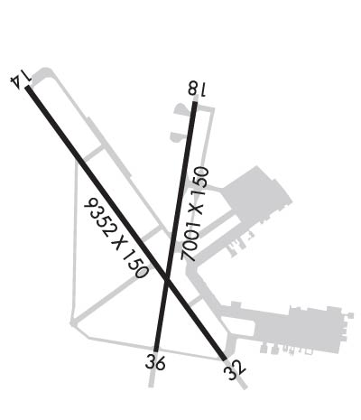
| Lat: N 3119.6 Long: W 09232.9 Elev: 88 Var: -03 Longest Runway: 9352 | ||
| Clr Del: 121.9 Ground: 121.9 Tower: 127.35 | ||
| ||||||||||||||||||||||||||||||||||||||||||||
| ||||||||||||||||||||||||||||||||||||||||||||
| ||||||||||||||||||||||||||||||||||||||||||||
| Rwy | Rwy | |||||||
| 9352x150 | 9352' | 110.10 - 141° | 9352x150 | 9352' | ||||
| 7001x150 | 7001' | 7001x150 | 7001' | |||||
| Runway ID | Single Wheel | Double Wheel | Double Tandem Wheel | Dual Double Wheel |
| 14/32 | 81,000 | 180,000 | 330,000 | 850,000 |
| 18/36 | 75,000 | 130,000 | 191,000 | 502,000 |
| These numbers are Advisory and are not limits. The Airport Manager should have more accurate Weight Limits | ||||
 Airport Diagram might not be current. | |
| Facility Name: | ALEXANDRIA INTL |
| City Name: | ALEXANDRIA |
| County: | RAPIDES |
| State abbrev: | LA |
| State Name: | LOUISIANA |
| Ownership: | PUBLICLY OWNED |
| Use: | OPEN TO THE PUBLIC |
| Owner's Name: | ENGLAND AUTHORITY |
| Address: | 1611 ARNOLD DR |
| ALEXANDRIA, LA 71303 | |
| Owner's Phone: | 318-449-3504 |
| Manager's Name: | SCOTT GAMMEL |
| Address: | 1611 ARNOLD DR |
| ALEXANDRIA, LA 71303 | |
| Phone: | 318-427-6419 |
| FAA Region: | SOUTHWEST |
| FAA Field Office: | LNM |
| Date | Sunrise | Sunset |
|---|---|---|
| 09/24/21 Friday | 6:59 | 19:04 |
| 09/25/21 Saturday | 7:00 | 19:03 |
| 09/26/21 Sunday | 7:01 | 19:02 |
| 09/27/21 Monday | 7:01 | 19:01 |
| 09/28/21 Tuesday | 7:02 | 18:59 |
| 09/29/21 Wednesday | 7:03 | 18:58 |
| 09/30/21 Thursday | 7:03 | 18:57 |
| 10/01/21 Friday | 7:04 | 18:56 |
| 10/02/21 Saturday | 7:04 | 18:54 |
| 10/03/21 Sunday | 7:05 | 18:53 |
| 10/04/21 Monday | 7:06 | 18:52 |
| 10/05/21 Tuesday | 7:06 | 18:50 |
| 10/06/21 Wednesday | 7:07 | 18:49 |
| 10/07/21 Thursday | 7:08 | 18:48 |
| Airport Attendance Schedule | CONTINUOUS |
| Airport Status | OPERATIONAL (This Status can change at any time - please check NOTAMS) |
| Airport Lighting Schedule | SS-SR |
| Airport Storage Available | Tie Downs, Hanger |
| Extra Services Available | Charter, Flight Instruction, Aircraft Rental, Aircraft Sales |
| Wind Indicator | YES - (lighted) |
| Control Tower | YES |
| CTAF Frequency | 127.350 |
| Unicom Frequency | MULTICOM FREQ 130.00 AVBL. |
| Rotating Beacon Color | CLEAR-GREEN (Light Land Airport) |
| Segmented Circle | YES |
| Landing Fee | NO |
| Airport Inspected | STATE - performed by FAA AIRPORTS FIELD PERSONNEL |
| Inspection Date | 02/13/2020 |
| Type of Fuel Available | Grade 100, JET A (freeze point -40C)MOGAS |
| Airframe Repair Service | MAJOR |
| Power Plant Repair Service | MAJOR |
| Latitude | N3119.6 |
| Longitude | W09232.9 (ESTIMATED) |
| Arpt Elevation | 88ft (SURVEYED) |
| Magnetic Variation | 03E |
| 4 miles W | of ALEXANDRIA |
| Traffic Pattern Altitude | 1200; RIGHT RETANGULAR 1200 FT AGL, LEFT OVERHEAD 1700 FT AGL. |
| Sectional Chart | HOUSTON |
| Operations (Reported) | Yearly | Avg. Daily |
|---|---|---|
| General Aviation Transient | 7996 | 22 |
| General Aviation Local | 2837 | 8 |
| Air Taxi | 4655 | 13 |
| Commerical | 1927 | 5 |
| Commuter | 0 | 0 |
| Military | 4740 | 13 |
| Aircraft based on Field | |
|---|---|
| General Aviation Singles | 31 |
| General Aviation Multi | 4 |
| Jet Aircraft | 11 |
| General Aviation Helicopters | 4 |
| Military Aircraft | 0 |
| Gliders | 0 |
| Ultralights | 0 |
| FSS on field | NO |
| FSS tie-in | DE RIDDER |
| FSS Phone | 1-800-WX-BRIEF |
| Who issues Notams | AEX |
| Notam D service at airport | YES |
| ARTCC Name | HOUSTON |
| Airport Certification | AIRPORT RECEIVING SCHEDULED AIR CARRIER SERVICE FROM CARRIERS CERTIFICATED BY THE CIVIL AERONAUTICS BOARD |
| Aircraft Rescue & Firefighting Index | AIRPORT HAS A CERTIFICATE UNDER CFR PART 139 |
| Airport of Entry | No |
| Custom Landing Rights | No |
| Joint Civil/Military | No |
| Military Landing rights | YES |
| NATIONAL PLAN OF INTEGRATED AIRPORT SYSTEMS (NPIAS) |
| SURPLUS PROPERTY AGREEMENT UNDER PUBLIC LAW 289 |
| LGT ACFT FREQ CROSS APCH ZONES TO RWY 14/32 BLW 2000 FT MSL. |
| COML & LIFEGUARD ACFT ONLY ON COML TRML RAMP; ALL OTHER ACFT UTILIZE TWY A TO FBO. |
| TWY F CLSD INDEFLY. |
| EXTV LGT ACFT TFC (CROPDUSTERS) BLW 900 FT TO CIV ARPT 3.5 NM WSW OF FIELD. |
| LOCKED WHEEL AND SHARP TURNS PROHIBITED ON ASPH SFC. |
| TWY E BTN TWY F & RWY 36 CLSD INDEFLY. |
| TWY G CLSD INDEFLY. |
| EXTSV HEL TFC DURING MIL EXER. |
| RWY 18/3 6 CENTER 75 FT OF FIRST 3000 FT OF RWY 18 CONC, REMAINDER IS ASPH. |
Airport Communications & Frequencies:
| ||||||||||||||||||||||||||||
| Runway: 14 | Runway: 32 | ||
| Mag heading: | 141° | Mag heading: | 321° |
| Rwy Slope: | .05% Up | Rwy Slope: | -.05% Down |
| Approach: | LOC/GS | Approach: | |
| Pattern: | Left Traffic | Pattern: | Left Traffic |
| Markings: | PRECISION INSTRUMENT | Markings: | PRECISION INSTRUMENT |
| Marking Condition: | GOOD | Marking Condition: | GOOD |
| Arresting Dev: | MA-1A MOD | Arresting Dev: | MA-1A MOD |
| Lat & Long: | N3120.3 W09233.6 | Lat. & Long.: | N3119.0 W09232.5 |
| Elev: | 83.7 ft. MSL | Elev: | 88.0 ft. MSL |
| TCH: | 71 ft. AGL | TCH: | 80 ft. AGL |
| Visual Glide Path: | 3.00 degrees | Visual Glide Path: | 3.00 degrees |
| Displaced Threshold: | No | Displaced Threshold: | No |
| Touchdown Zone: | YES | Touchdown Zone: | YES |
| Touchdown Elev.: | 85.0 feet | Touchdown Elev.: | 88.1 feet |
| Visual Glide Slope: | 4-Light PAPI on LEFT side of Runway | Visual Glide Slope: | 4-Light PAPI on LEFT side of Runway |
| RVR Equipment: | TOUCHDOWN-ROLLOUT | RVR Equipment: | TOUCHDOWN-ROLLOUT |
| RVV Equipment: | NO | RVV Equipment: | NO |
| Approach Lights: | SSALR - simplified short approach lighting system with runway alignment indicator lights | Approach Lights: | |
| REIL: | NO | REIL: | YES |
| Centerline Lights: | NO | Centerline Lights: | NO |
| Touchdown lights: | NO | Touchdown lights: | NO |
| Runway Category: | Precision Instrument Runway | Runway Category: | Runway with a Non-precision Approach having visibility minimums greater than 3/4 mile |
| Declared Distances: | TORA:9352' TODA:9352' ASDA:9352' LDA:9352' | Declared Distances: | TORA:9352' TODA:9352' ASDA:9352' LDA:9352' |
| Runway: 18 | Runway: 36 | ||
| Mag heading: | 186° | Mag heading: | 6° |
| Rwy Slope: | .05% Up | Rwy Slope: | -.05% Down |
| Approach: | Approach: | ||
| Pattern: | Left Traffic | Pattern: | Left Traffic |
| Markings: | NONPRECISION INSTRUMENT | Markings: | NONPRECISION INSTRUMENT |
| Marking Condition: | GOOD | Marking Condition: | GOOD |
| Arresting Dev: | Arresting Dev: | ||
| Lat & Long: | N3120.2 W09232.7 | Lat. & Long.: | N3119.1 W09232.9 |
| Elev: | 83.5 ft. MSL | Elev: | 86.7 ft. MSL |
| TCH: | 79 ft. AGL | TCH: | 77 ft. AGL |
| Visual Glide Path: | 3.00 degrees | Visual Glide Path: | 3.00 degrees |
| Displaced Threshold: | No | Displaced Threshold: | No |
| Touchdown Zone: | YES | Touchdown Zone: | YES |
| Touchdown Elev.: | 84.0 feet | Touchdown Elev.: | 86.8 feet |
| Visual Glide Slope: | 4-Light PAPI on LEFT side of Runway | Visual Glide Slope: | 4-Light PAPI on LEFT side of Runway |
| RVR Equipment: | RVR Equipment: | ||
| RVV Equipment: | NO | RVV Equipment: | NO |
| Approach Lights: | Approach Lights: | ||
| REIL: | YES | REIL: | YES |
| Centerline Lights: | NO | Centerline Lights: | NO |
| Touchdown lights: | NO | Touchdown lights: | NO |
| Runway Category: | Runway with a Non-precision Approach having visibility minimums greater than 3/4 mile | Runway Category: | Runway with a Visual Approach |
| Declared Distances: | TORA:7001' TODA:7001' ASDA:7001' LDA:7001' | Declared Distances: | TORA:7001' TODA:7001' ASDA:7001' LDA:7001' |
| Obstructions: | Obstructions: | TREES | |
| Marked: | Marked: | NOT Marked/Lighted | |
| Clearance slope: | 34:1 | Clearance slope: | 21:1 |
| Obstruction height: | Obstruction height: | 76 feet AGL | |
| Dist. from runway: | Dist. from runway: | 1798 feet | |
| Centerline offset: | Centerline offset: | 322 feet right of centerline | |
| Comments: | Comments: |
Thanks for using FltPlan.com
all rights reserved © 1999-2021 by Flight Plan LLC
