
| ALBERT LEA MUNI ALBERT LEA MN |
| |
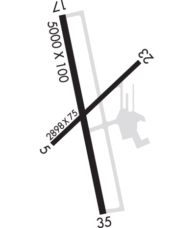
| Lat: N 4340.9 Long: W 09322.1 Elev: 1261 Var: -01 Longest Runway: 5000 | ||
| AWOS: 109.8 CTAF: 123.0 | ||
| ||||||||||||||||||||||||||||||||||||||||||||
| ||||||||||||||||||||||||||||||||||||||||||||
| ||||||||||||||||||||||||||||||||||||||||||||
| Rwy | Rwy | |||||||
| 2898x75 | 2898' | 2898x75 | 2898' | |||||
| 5000x100 | 5000' | 5000x100 | 5000' | |||||
| Runway ID | Single Wheel | Double Wheel | Double Tandem Wheel | Dual Double Wheel |
| 05/23 | N/A | N/A | N/A | N/A |
| 17/35 | 19,000 | 29,000 | N/A | N/A |
| These numbers are Advisory and are not limits. The Airport Manager should have more accurate Weight Limits | ||||
 Airport Diagram might not be current. | |
| Facility Name: | ALBERT LEA MUNI |
| City Name: | ALBERT LEA |
| County: | FREEBORN |
| State abbrev: | MN |
| State Name: | MINNESOTA |
| Ownership: | PUBLICLY OWNED |
| Use: | OPEN TO THE PUBLIC |
| Owner's Name: | CITY OF ALBERT LEA |
| Address: | 221 E CLARK STREET |
| ALBERT LEA, MN 56007 | |
| Owner's Phone: | 507-377-4300 |
| Manager's Name: | JIM HANSON |
| Address: | 73950 275TH ST.; EMAIL ADDRESS: JIMHANSON@DESKMEDIA.COM (ALL LOWER CASE) |
| CLARKS GROVE, MN 56016 | |
| Phone: | 507-373-0608 |
| FAA Region: | GREAT LAKES |
| FAA Field Office: | DMA |
| Date | Sunrise | Sunset |
|---|---|---|
| 09/24/21 Friday | 7:03 | 19:08 |
| 09/25/21 Saturday | 7:04 | 19:06 |
| 09/26/21 Sunday | 7:05 | 19:04 |
| 09/27/21 Monday | 7:06 | 19:02 |
| 09/28/21 Tuesday | 7:07 | 19:00 |
| 09/29/21 Wednesday | 7:08 | 18:58 |
| 09/30/21 Thursday | 7:10 | 18:57 |
| 10/01/21 Friday | 7:11 | 18:55 |
| 10/02/21 Saturday | 7:12 | 18:53 |
| 10/03/21 Sunday | 7:13 | 18:51 |
| 10/04/21 Monday | 7:14 | 18:49 |
| 10/05/21 Tuesday | 7:15 | 18:48 |
| 10/06/21 Wednesday | 7:17 | 18:46 |
| 10/07/21 Thursday | 7:18 | 18:44 |
| Airport Attendance Schedule | APR-OCT MON-FRI 0800-2000, NOV-MAR MON-FRI 0800-1700, SAT-SUN 0800-1700; FOR SVC AFT HRS CALL 507-826-3451. |
| Airport Status | OPERATIONAL (This Status can change at any time - please check NOTAMS) |
| Airport Lighting Schedule | ACTVT ODALS RWY 17; REIL RWY 17 & 35; PAPI RWY 17 & 35; MIRL RWY 17/35 - CTAF. MIRL RWY 17/35 PRESET TO LOW SS-SR TO INCR INTST - CTAF. |
| Airport Storage Available | Tie Downs, Hanger |
| Extra Services Available | Flight Instruction, Aircraft Rental, Aircraft Sales |
| Wind Indicator | YES - (lighted) |
| Control Tower | NO |
| CTAF Frequency | 123.000 |
| Unicom Frequency | 123.000 |
| Rotating Beacon Color | CLEAR-GREEN (Light Land Airport) |
| Segmented Circle | NO |
| Landing Fee | NO |
| Airport Inspected | STATE - performed by STATE AERONAUTICAL PERSONNEL |
| Inspection Date | 06/06/2020 |
| Type of Fuel Available | Grade 100LL, JET A (freeze point -40C)MOGAS; -10100LL & MOGAS FUEL AVBL 24 HR WITH CREDIT CARD. |
| Airframe Repair Service | MINOR |
| Power Plant Repair Service | MINOR |
| Latitude | N4340.9 |
| Longitude | W09322.1 (ESTIMATED) |
| Arpt Elevation | 1261ft (SURVEYED) |
| Magnetic Variation | 01E |
| 3 miles N | of ALBERT LEA |
| Traffic Pattern Altitude | 740 |
| Sectional Chart | OMAHA |
| Operations (Reported) | Yearly | Avg. Daily |
|---|---|---|
| General Aviation Transient | 6775 | 19 |
| General Aviation Local | 17100 | 47 |
| Air Taxi | 2000 | 5 |
| Commerical | 0 | 0 |
| Commuter | 0 | 0 |
| Military | 300 | 1 |
| Aircraft based on Field | |
|---|---|
| General Aviation Singles | 33 |
| General Aviation Multi | 3 |
| Jet Aircraft | 1 |
| General Aviation Helicopters | 1 |
| Military Aircraft | 0 |
| Gliders | 0 |
| Ultralights | 0 |
| FSS on field | NO |
| FSS tie-in | PRINCETON |
| FSS Phone | 1-800-WX-BRIEF |
| Who issues Notams | AEL |
| Notam D service at airport | YES |
| ARTCC Name | MINNEAPOLIS |
| Airport Certification | |
| Aircraft Rescue & Firefighting Index | None |
| Airport of Entry | No |
| Custom Landing Rights | No |
| Joint Civil/Military | No |
| Military Landing rights | YES |
| NATIONAL PLAN OF INTEGRATED AIRPORT SYSTEMS (NPIAS) |
| GRANT AGREEMENTS UNDER FAAP/ADAP/AIP |
| ASSURANCES PURSUANT TO TITLE VI, CIVIL RIGHTS ACT OF 1964 |
| TV TWR 9.5 NM SE. |
| GLIDERS & HELICOPTERS USE TURF PARALLEL TO RY 17/35 ON EAST SIDE & APPR AREA TO RY 23. |
| MULTIPLE TRANSITIONAL OBSTNS RY 05 & RY 35. |
| FOR CD CTC ROCHESTER APCH AT 507-424-8111. |
Airport Communications & Frequencies:
| |||||||||||||||||
| Runway: 05 | Runway: 23 | ||
| Mag heading: | 46° | Mag heading: | 226° |
| Rwy Slope: | .14% Up | Rwy Slope: | -.14% Down |
| Approach: | Approach: | ||
| Pattern: | Left Traffic | Pattern: | Left Traffic |
| Markings: | NONPRECISION INSTRUMENT | Markings: | NONPRECISION INSTRUMENT |
| Marking Condition: | GOOD | Marking Condition: | GOOD |
| Arresting Dev: | Arresting Dev: | ||
| Lat & Long: | N4340.7 W09322.3 | Lat. & Long.: | N4341.1 W09321.8 |
| Elev: | 1252.8 ft. MSL | Elev: | 1256.9 ft. MSL |
| TCH: | TCH: | ||
| Visual Glide Path: | Visual Glide Path: | ||
| Displaced Threshold: | No | Displaced Threshold: | No |
| Touchdown Zone: | YES | Touchdown Zone: | YES |
| Touchdown Elev.: | 1256.9 feet | Touchdown Elev.: | 1256.9 feet |
| Visual Glide Slope: | Visual Glide Slope: | ||
| RVR Equipment: | RVR Equipment: | ||
| RVV Equipment: | NO | RVV Equipment: | NO |
| Approach Lights: | Approach Lights: | ||
| REIL: | NO | REIL: | NO |
| Centerline Lights: | NO | Centerline Lights: | NO |
| Touchdown lights: | NO | Touchdown lights: | NO |
| Runway Category: | Runway with a Visual Approach | Runway Category: | Runway with a Visual Approach |
| Declared Distances: | Declared Distances: | ||
| Obstructions: | TREES | Obstructions: | |
| Marked: | NOT Marked/Lighted | Marked: | |
| Clearance slope: | 16:1 | Clearance slope: | 20:1 |
| Obstruction height: | 27 feet AGL | Obstruction height: | |
| Dist. from runway: | 647 feet | Dist. from runway: | |
| Centerline offset: | 85 left of centerline | Centerline offset: | |
| Comments: | Comments: |
| Runway: 17 | Runway: 35 | ||
| Mag heading: | 167° | Mag heading: | 347° |
| Rwy Slope: | .02% Up | Rwy Slope: | -.02% Down |
| Approach: | Approach: | ||
| Pattern: | Left Traffic | Pattern: | Left Traffic |
| Markings: | NONPRECISION INSTRUMENT | Markings: | NONPRECISION INSTRUMENT |
| Marking Condition: | GOOD | Marking Condition: | GOOD |
| Arresting Dev: | Arresting Dev: | ||
| Lat & Long: | N4341.3 W09322.2 | Lat. & Long.: | N4340.5 W09322.0 |
| Elev: | 1260.0 ft. MSL | Elev: | 1261.0 ft. MSL |
| TCH: | 30 ft. AGL | TCH: | 30 ft. AGL |
| Visual Glide Path: | 3.00 degrees | Visual Glide Path: | 3.00 degrees |
| Displaced Threshold: | No | Displaced Threshold: | No |
| Touchdown Zone: | YES | Touchdown Zone: | YES |
| Touchdown Elev.: | 1260.0 feet | Touchdown Elev.: | 1261.0 feet |
| Visual Glide Slope: | 4-Light PAPI on LEFT side of Runway | Visual Glide Slope: | 4-Light PAPI on LEFT side of Runway |
| RVR Equipment: | RVR Equipment: | ||
| RVV Equipment: | NO | RVV Equipment: | NO |
| Approach Lights: | ODALS - omnidirectional approach lighting system | Approach Lights: | |
| REIL: | YES | REIL: | YES |
| Centerline Lights: | NO | Centerline Lights: | NO |
| Touchdown lights: | NO | Touchdown lights: | NO |
| Runway Category: | D | Runway Category: | D |
| Declared Distances: | Declared Distances: | ||
| Obstructions: | Obstructions: | TREE | |
| Marked: | Marked: | NOT Marked/Lighted | |
| Clearance slope: | 34:1 | Clearance slope: | 13:1 |
| Obstruction height: | Obstruction height: | 21 feet AGL | |
| Dist. from runway: | Dist. from runway: | 478 feet | |
| Centerline offset: | Centerline offset: | 274 feet left of centerline | |
| Comments: | Comments: | 24 FT TREE 68 FT FROM RWY END 354 FT L. |
Thanks for using FltPlan.com
all rights reserved © 1999-2021 by Flight Plan LLC
