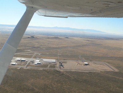
| DOUBLE EAGLE II ALBUQUERQUE NM |
| |
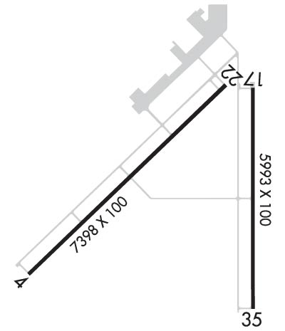
| Lat: N 3508.7 Long: W 10647.7 Elev: 5837 Var: -11 Longest Runway: 7398 | ||
| Clr Del: 124.8 TWR CLD AWOS: 119.02 Ground: 121.62 Tower: 120.15 | ||
| ||||||
| ||||||
|
| Rwy | Rwy | |||||||
| 7398x100 | 7398' | 7398x100 | 7398' | 110.10 - 215° | ||||
| 5983x100 | 5983' | 5983x100 | 5983' | |||||
| Runway ID | Single Wheel | Double Wheel | Double Tandem Wheel | Dual Double Wheel |
| 04/22 | 30,000 | N/A | N/A | N/A |
| 17/35 | 30,000 | N/A | N/A | N/A |
| These numbers are Advisory and are not limits. The Airport Manager should have more accurate Weight Limits | ||||
 Airport Diagram might not be current. | |
| Facility Name: | DOUBLE EAGLE II |
| City Name: | ALBUQUERQUE |
| County: | BERNALILLO |
| State abbrev: | NM |
| State Name: | NEW MEXICO |
| Ownership: | PUBLICLY OWNED |
| Use: | OPEN TO THE PUBLIC |
| Owner's Name: | CITY OF ALBUQUERQUE |
| Address: | PO BOX 9948 |
| ALBUQUERQUE, NM 87119 | |
| Owner's Phone: | (505) 244-7888 |
| Manager's Name: | MIKE MEDLEY |
| Address: | PO BOX 9948 |
| ALBUQUERQUE, NM 87119 | |
| Phone: | 505-244-7888 |
| FAA Region: | SOUTHWEST |
| FAA Field Office: | LNM |
| Date | Sunrise | Sunset |
|---|---|---|
| 09/24/21 Friday | 6:56 | 19:01 |
| 09/25/21 Saturday | 6:57 | 19:00 |
| 09/26/21 Sunday | 6:58 | 18:58 |
| 09/27/21 Monday | 6:59 | 18:57 |
| 09/28/21 Tuesday | 7:00 | 18:56 |
| 09/29/21 Wednesday | 7:00 | 18:54 |
| 09/30/21 Thursday | 7:01 | 18:53 |
| 10/01/21 Friday | 7:02 | 18:51 |
| 10/02/21 Saturday | 7:03 | 18:50 |
| 10/03/21 Sunday | 7:03 | 18:49 |
| 10/04/21 Monday | 7:04 | 18:47 |
| 10/05/21 Tuesday | 7:05 | 18:46 |
| 10/06/21 Wednesday | 7:06 | 18:44 |
| 10/07/21 Thursday | 7:07 | 18:43 |
| Airport Attendance Schedule | 7 Days A Week 0600-1900; FOR ATTENDANT AFT HRS CALL 505-884-4530. |
| Airport Status | OPERATIONAL (This Status can change at any time - please check NOTAMS) |
| Airport Lighting Schedule | WHEN ATCT CLSD ACTVT MALSR RWY 22; REIL RWY 17 & 35; PAPI RWY 04 & 17; MIRL RWY 04/22 & 17/35 - CTAF. |
| Airport Storage Available | Tie Downs, Hanger |
| Extra Services Available | Air Ambulance, Charter, Flight Instruction, Aircraft Rental |
| Wind Indicator | YES - (lighted) |
| Control Tower | YES |
| CTAF Frequency | 120.150 |
| Unicom Frequency | |
| Rotating Beacon Color | CLEAR-GREEN (Light Land Airport) |
| Segmented Circle | YES |
| Landing Fee |
| Airport Inspected | STATE - performed by STATE AERONAUTICAL PERSONNEL |
| Inspection Date | 04/11/2019 |
| Type of Fuel Available | Grade 100LL, JET A-1 (freeze point -50C); -10100LL AVBL 24 HRS SELF-SERVICE WITH MAJOR CREDIT CARD.; -A1$150 CALL-OUT FEE FOR JET A1. |
| Airframe Repair Service | MAJOR |
| Power Plant Repair Service | MAJOR |
| Latitude | N3508.7 |
| Longitude | W10647.7 (ESTIMATED) |
| Arpt Elevation | 5837ft (SURVEYED) |
| Magnetic Variation | 11E |
| 7 miles NW | of ALBUQUERQUE |
| Traffic Pattern Altitude | |
| Sectional Chart | ALBUQUERQUE |
| Operations (Reported) | Yearly | Avg. Daily |
|---|---|---|
| General Aviation Transient | 24730 | 68 |
| General Aviation Local | 51730 | 142 |
| Air Taxi | 1200 | 3 |
| Commerical | 0 | 0 |
| Commuter | 0 | 0 |
| Military | 1200 | 3 |
| Aircraft based on Field | |
|---|---|
| General Aviation Singles | 96 |
| General Aviation Multi | 15 |
| Jet Aircraft | 1 |
| General Aviation Helicopters | 7 |
| Military Aircraft | 0 |
| Gliders | 1 |
| Ultralights | 5 |
| FSS on field | NO |
| FSS tie-in | ALBUQUERQUE |
| FSS Phone | 1-800-WX-BRIEF |
| Who issues Notams | AEG |
| Notam D service at airport | YES |
| ARTCC Name | ALBUQUERQUE |
| Airport Certification | |
| Aircraft Rescue & Firefighting Index | None |
| Airport of Entry | No |
| Custom Landing Rights | No |
| Joint Civil/Military | No |
| Military Landing rights | YES |
| NATIONAL PLAN OF INTEGRATED AIRPORT SYSTEMS (NPIAS) |
| GRANT AGREEMENTS UNDER FAAP/ADAP/AIP |
| ASSURANCES PURSUANT TO TITLE VI, CIVIL RIGHTS ACT OF 1964 |
| WILDLIFE ON AND INVOF ARPT. |
| TWYS B1 & B BTN MAIN RAMP AND TWY B2 CLSD 2200-0600. |
| TWY A CLSD BTN TWY A1 AND TWY B 2200-0600. |
| LIVE FIRE RANGE 1.6NM WEST OF THE APPROACH END OF RWY 04 AVOIDANCE ADVISED. |
Airport Communications & Frequencies:
| ||||||||||||||||||
| Runway: 04 | Runway: 22 | ||
| Mag heading: | 35° | Mag heading: | 215° |
| Rwy Slope: | -.37% Down | Rwy Slope: | .37% Up |
| Approach: | Approach: | ILS | |
| Pattern: | Left Traffic | Pattern: | Right Traffic |
| Markings: | PRECISION INSTRUMENT | Markings: | PRECISION INSTRUMENT |
| Marking Condition: | GOOD | Marking Condition: | GOOD |
| Arresting Dev: | Arresting Dev: | ||
| Lat & Long: | N3508.3 W10648.6 | Lat. & Long.: | N3509.2 W10647.5 |
| Elev: | 5837.4 ft. MSL | Elev: | 5810.1 ft. MSL |
| TCH: | 52 ft. AGL | TCH: | |
| Visual Glide Path: | 3.00 degrees | Visual Glide Path: | |
| Displaced Threshold: | No | Displaced Threshold: | No |
| Touchdown Zone: | YES | Touchdown Zone: | YES |
| Touchdown Elev.: | 5837.4 feet | Touchdown Elev.: | 5817.4 feet |
| Visual Glide Slope: | 4-Light PAPI on LEFT side of Runway | Visual Glide Slope: | |
| RVR Equipment: | RVR Equipment: | ||
| RVV Equipment: | NO | RVV Equipment: | NO |
| Approach Lights: | Approach Lights: | MALSR - 1,400 foot medium intensity approach lighting system with runway alignment indicator lights | |
| REIL: | NO | REIL: | NO |
| Centerline Lights: | NO | Centerline Lights: | NO |
| Touchdown lights: | NO | Touchdown lights: | NO |
| Runway Category: | Runway with a Visual Approach | Runway Category: | Precision Instrument Runway |
| Declared Distances: | Declared Distances: |
| Runway: 17 | Runway: 35 | ||
| Mag heading: | 169° | Mag heading: | 349° |
| Rwy Slope: | -.13% Down | Rwy Slope: | .13% Up |
| Approach: | Approach: | ||
| Pattern: | Left Traffic | Pattern: | Right Traffic |
| Markings: | NONPRECISION INSTRUMENT | Markings: | NONPRECISION INSTRUMENT |
| Marking Condition: | GOOD | Marking Condition: | GOOD |
| Arresting Dev: | Arresting Dev: | ||
| Lat & Long: | N3509.1 W10647.3 | Lat. & Long.: | N3508.1 W10647.3 |
| Elev: | 5805.9 ft. MSL | Elev: | 5798.2 ft. MSL |
| TCH: | 52 ft. AGL | TCH: | |
| Visual Glide Path: | 3.00 degrees | Visual Glide Path: | |
| Displaced Threshold: | No | Displaced Threshold: | No |
| Touchdown Zone: | YES | Touchdown Zone: | YES |
| Touchdown Elev.: | 5805.9 feet | Touchdown Elev.: | 5800.4 feet |
| Visual Glide Slope: | 4-Light PAPI on LEFT side of Runway | Visual Glide Slope: | |
| RVR Equipment: | RVR Equipment: | ||
| RVV Equipment: | NO | RVV Equipment: | NO |
| Approach Lights: | Approach Lights: | ||
| REIL: | YES | REIL: | YES |
| Centerline Lights: | NO | Centerline Lights: | NO |
| Touchdown lights: | NO | Touchdown lights: | NO |
| Runway Category: | Runway with a Visual Approach | Runway Category: | Runway with a Visual Approach |
| Declared Distances: | Declared Distances: |
Thanks for using FltPlan.com
all rights reserved © 1999-2021 by Flight Plan LLC