
| ALTURAS MUNI ALTURAS CA |
| |
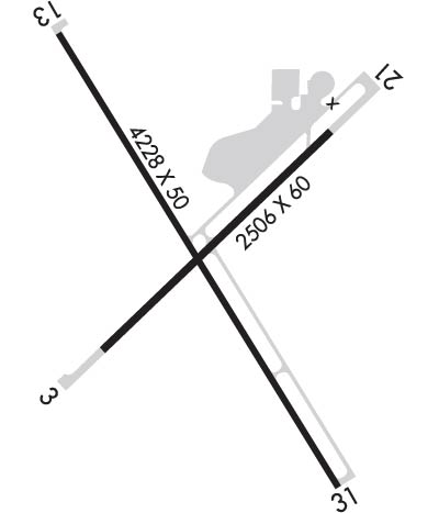
| Lat: N 4129.0 Long: W 12033.9 Elev: 4378 Var: -16 Longest Runway: 4228 | ||
| AWOS: 124.17 CTAF: 122.8 | ||
| ||||||
| ||||||
|
| Rwy | Rwy | |||||||
| 2506x60 | 2506' | 2506x60 | 2506' | |||||
| 4228x50 | 4228' | 4228x50 | 4228' | |||||
| Runway ID | Single Wheel | Double Wheel | Double Tandem Wheel | Dual Double Wheel |
| 03/21 | 12,000 | N/A | N/A | N/A |
| 13/31 | 12,000 | N/A | N/A | N/A |
| These numbers are Advisory and are not limits. The Airport Manager should have more accurate Weight Limits | ||||
 Airport Diagram might not be current. | |
| Facility Name: | ALTURAS MUNI |
| City Name: | ALTURAS |
| County: | MODOC |
| State abbrev: | CA |
| State Name: | CALIFORNIA |
| Ownership: | PUBLICLY OWNED |
| Use: | OPEN TO THE PUBLIC |
| Owner's Name: | CITY OF ALTURAS; OPERD BY CITY OF ALTURAS. |
| Address: | 200 NORTH STREET |
| ALTURAS, CA 96101 | |
| Owner's Phone: | 530-233-2512 |
| Manager's Name: | WARREN FARNAM; DIR. OF PUBLIC WORKS (530) 233-2377. |
| Address: | 200 NORTH STREET |
| ALTURAS, CA 96101 | |
| Phone: | 530-233-2377; PUBLIC WORKS IN ALTURAS. FBO AT ARPT 530-233-5125 OR 530-708-1852. |
| FAA Region: | WESTERN-PACIFIC |
| FAA Field Office: | SFO |
| Date | Sunrise | Sunset |
|---|---|---|
| 06/08/26 Monday | 5:29 | 20:34 |
| 06/09/26 Tuesday | 5:28 | 20:35 |
| 06/10/26 Wednesday | 5:28 | 20:35 |
| 06/11/26 Thursday | 5:28 | 20:36 |
| 06/12/26 Friday | 5:28 | 20:36 |
| 06/13/26 Saturday | 5:28 | 20:37 |
| 06/14/26 Sunday | 5:28 | 20:37 |
| 06/15/26 Monday | 5:28 | 20:38 |
| 06/16/26 Tuesday | 5:28 | 20:38 |
| 06/17/26 Wednesday | 5:28 | 20:38 |
| 06/18/26 Thursday | 5:28 | 20:39 |
| 06/19/26 Friday | 5:28 | 20:39 |
| 06/20/26 Saturday | 5:28 | 20:39 |
| 06/21/26 Sunday | 5:28 | 20:40 |
| Airport Attendance Schedule | 7 Days A Week 0800-1700 |
| Airport Status | OPERATIONAL (This Status can change at any time - please check NOTAMS) |
| Airport Lighting Schedule | ACTVT REIL RWY 03 & 31; VASI RWY 03; MIRL RWY 13/31; LIRL RWY 03/21 - CTAF. |
| Airport Storage Available | Tie Downs |
| Extra Services Available | Air Ambulance, Charter, Flight Instruction |
| Wind Indicator | YES - (lighted) |
| Control Tower | NO |
| CTAF Frequency | 122.800 |
| Unicom Frequency | 122.800 |
| Rotating Beacon Color | WG |
| Segmented Circle | YES |
| Landing Fee | NO |
| Airport Inspected | STATE - performed by STATE AERONAUTICAL PERSONNEL |
| Inspection Date | 04/16/2026 |
| Type of Fuel Available | Grade 100LL, JET A (freeze point -40C) |
| Airframe Repair Service | NONE |
| Power Plant Repair Service | NONE |
| Latitude | N4129.0 |
| Longitude | W12033.9 (ESTIMATED) |
| Arpt Elevation | 4378ft (SURVEYED) |
| Magnetic Variation | 16E |
| 1 miles W | of ALTURAS |
| Traffic Pattern Altitude | |
| Sectional Chart | KLAMATH FALLS |
| Operations (Reported) | Yearly | Avg. Daily |
|---|---|---|
| General Aviation Transient | 0 | 0 |
| General Aviation Local | 0 | 0 |
| Air Taxi | 0 | 0 |
| Commerical | 0 | 0 |
| Commuter | 0 | 0 |
| Military | 0 | 0 |
| Aircraft based on Field | |
|---|---|
| General Aviation Singles | 0 |
| General Aviation Multi | 0 |
| Jet Aircraft | 0 |
| General Aviation Helicopters | 0 |
| Military Aircraft | 0 |
| Gliders | 0 |
| Ultralights | 0 |
| FSS on field | NO |
| FSS tie-in | RENO |
| FSS Phone | 1-800-WX-BRIEF |
| Who issues Notams | AAT |
| Notam D service at airport | YES |
| ARTCC Name | SEATTLE |
| Airport Certification | |
| Aircraft Rescue & Firefighting Index | None |
| Airport of Entry | No |
| Custom Landing Rights | No |
| Joint Civil/Military | No |
| Military Landing rights | No |
| NATIONAL PLAN OF INTEGRATED AIRPORT SYSTEMS (NPIAS) |
| GRANT AGREEMENTS UNDER FAAP/ADAP/AIP |
| ASSURANCES PURSUANT TO TITLE VI, CIVIL RIGHTS ACT OF 1964 |
| NO TKOF RY 03 TO NE EXCP DURG ADVERSE WIND COND. 150 FT MIN ALT OVER HOUSES. |
| WILDLIFE REFUGES TO THE SW; SOUTH AND SE PRESENT POTENTIAL BIRD HAZARDS TO ACFT FROM OCT THRU APR. |
| FIRE FIGHTTING ACFT SEASONAL MAY-OCT. |
| ARRIVALS RY 21 DISCOURAGED DUE TO SCHOOL ON APCH. |
| DEER ON AND IN THE VICINITY OF ARPT. |
| FOR CD CTC SEATTLE ARTCC AT 253-351-3694. |
| RWY 03/2 1 GROSS PAVEMENT STRENGTH PROVIDED BY AIRPORT MANAGER. |
Airport Communications & Frequencies:
| |||||||||
| Runway: 03 | Runway: 21 | ||
| Mag heading: | 30° | Mag heading: | 210° |
| Rwy Slope: | .50% Up | Rwy Slope: | -.50% Down |
| Approach: | Approach: | ||
| Pattern: | Left Traffic | Pattern: | Right Traffic |
| Markings: | BASIC | Markings: | BASIC |
| Marking Condition: | FAIR | Marking Condition: | FAIR |
| Arresting Dev: | Arresting Dev: | ||
| Lat & Long: | N4128.8 W12034.1 | Lat. & Long.: | N4129.1 W12033.7 |
| Elev: | 4365.4 ft. MSL | Elev: | 4378.0 ft. MSL |
| TCH: | 28 ft. AGL | TCH: | |
| Visual Glide Path: | 3.00 degrees | Visual Glide Path: | |
| Displaced Threshold: | No | Displaced Threshold: | No |
| Touchdown Zone: | YES | Touchdown Zone: | YES |
| Touchdown Elev.: | 4378.1 feet | Touchdown Elev.: | 4378.1 feet |
| Visual Glide Slope: | 2-Box VASI on LEFT side of Runway | Visual Glide Slope: | |
| RVR Equipment: | RVR Equipment: | ||
| RVV Equipment: | NO | RVV Equipment: | NO |
| Approach Lights: | Approach Lights: | ||
| REIL: | YES | REIL: | NO |
| Centerline Lights: | NO | Centerline Lights: | NO |
| Touchdown lights: | NO | Touchdown lights: | NO |
| Runway Category: | Runway with a Visual Approach | Runway Category: | Runway with a Visual Approach |
| Declared Distances: | Declared Distances: | ||
| Obstructions: | RR | Obstructions: | TREE |
| Marked: | NOT Marked/Lighted | Marked: | NOT Marked/Lighted |
| Clearance slope: | 3:1; RWY 03 APCH RATIO 22:1 FM DSPLCD THLD. | Clearance slope: | 9:1; RW 21 APCH RATIO 35:1 FM DSPLCD THLD. |
| Obstruction height: | 23 feet AGL | Obstruction height: | 20 feet AGL |
| Dist. from runway: | 275 feet | Dist. from runway: | 380 feet |
| Centerline offset: | Centerline offset: | ||
| Comments: | Comments: |
| Runway: 13 | Runway: 31 | ||
| Mag heading: | 132° | Mag heading: | 312° |
| Rwy Slope: | .21% Up | Rwy Slope: | -.21% Down |
| Approach: | Approach: | ||
| Pattern: | Right Traffic | Pattern: | Left Traffic |
| Markings: | NONPRECISION INSTRUMENT | Markings: | NONPRECISION INSTRUMENT |
| Marking Condition: | FAIR | Marking Condition: | FAIR |
| Arresting Dev: | Arresting Dev: | ||
| Lat & Long: | N4129.3 W12034.2 | Lat. & Long.: | N4128.7 W12033.7 |
| Elev: | 4369.1 ft. MSL | Elev: | 4378.1 ft. MSL |
| TCH: | TCH: | ||
| Visual Glide Path: | Visual Glide Path: | ||
| Displaced Threshold: | No | Displaced Threshold: | No |
| Touchdown Zone: | YES | Touchdown Zone: | YES |
| Touchdown Elev.: | 4371.7 feet | Touchdown Elev.: | 4378.3 feet |
| Visual Glide Slope: | Visual Glide Slope: | ||
| RVR Equipment: | RVR Equipment: | ||
| RVV Equipment: | NO | RVV Equipment: | NO |
| Approach Lights: | Approach Lights: | ||
| REIL: | NO | REIL: | YES |
| Centerline Lights: | NO | Centerline Lights: | NO |
| Touchdown lights: | NO | Touchdown lights: | NO |
| Runway Category: | Runway with a Visual Approach | Runway Category: | Runway with a Non-precision Approach |
| Declared Distances: | Declared Distances: | ||
| Obstructions: | ROAD | Obstructions: | RR |
| Marked: | NOT Marked/Lighted | Marked: | NOT Marked/Lighted |
| Clearance slope: | 6:1; RY 13 APCH RATIO 28:1 FM DSPLCD THR. | Clearance slope: | 3:1 |
| Obstruction height: | 16 feet AGL | Obstruction height: | 15 feet AGL |
| Dist. from runway: | 300 feet | Dist. from runway: | 250 feet |
| Centerline offset: | 150 left of centerline | Centerline offset: | 250 feet left of centerline |
| Comments: | Comments: |
Thanks for using FltPlan.com
all rights reserved © 1999-2026 by Flight Plan LLC
