
| LOGAN COUNTY LINCOLN IL |
| |
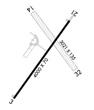
| Lat: N 4009.5 Long: W 08920.1 Elev: 594 Var: -00 Longest Runway: 4000 | ||
| AWOS: 118.77 CTAF: 122.8 | ||
| ||||||||||||||||||||||||||||||||||||||||||||||||||||||||||||||||||||
| ||||||||||||||||||||||||||||||||||||||||||||||||||||||||||||||||||||
| ||||||||||||||||||||||||||||||||||||||||||||||||||||||||||||||||||||
| Rwy | Rwy | |||||||
| 4000x75 | 4000' | 4000x75 | 4000' | |||||
| 3021x135 | 2714' | 3021x135 | 3021' | |||||
| Runway ID | Single Wheel | Double Wheel | Double Tandem Wheel | Dual Double Wheel |
| 03/21 | 12,500 | N/A | N/A | N/A |
| 14/32 | N/A | N/A | N/A | N/A |
| These numbers are Advisory and are not limits. The Airport Manager should have more accurate Weight Limits | ||||
 Airport Diagram might not be current. | |
| Facility Name: | LOGAN COUNTY |
| City Name: | LINCOLN |
| County: | LOGAN |
| State abbrev: | IL |
| State Name: | ILLINOIS |
| Ownership: | PUBLICLY OWNED |
| Use: | OPEN TO THE PUBLIC |
| Owner's Name: | LOGAN COUNTY BOARD |
| Address: | COUNTY COURTHOUSE, P.O. BOX 39 |
| LINCOLN, IL 62656 | |
| Owner's Phone: | 217-732-6400 |
| Manager's Name: | GENE ROHLFS |
| Address: | COUNTY COURT HOUSE, P.O. BOX 39 |
| LINCOLN, IL 62656 | |
| Phone: | 217-732-6400 |
| FAA Region: | GREAT LAKES |
| FAA Field Office: | CHI |
| Date | Sunrise | Sunset |
|---|---|---|
| 06/08/26 Monday | 5:28 | 20:25 |
| 06/09/26 Tuesday | 5:28 | 20:26 |
| 06/10/26 Wednesday | 5:28 | 20:26 |
| 06/11/26 Thursday | 5:27 | 20:27 |
| 06/12/26 Friday | 5:27 | 20:27 |
| 06/13/26 Saturday | 5:27 | 20:27 |
| 06/14/26 Sunday | 5:27 | 20:28 |
| 06/15/26 Monday | 5:27 | 20:28 |
| 06/16/26 Tuesday | 5:27 | 20:29 |
| 06/17/26 Wednesday | 5:27 | 20:29 |
| 06/18/26 Thursday | 5:28 | 20:29 |
| 06/19/26 Friday | 5:28 | 20:30 |
| 06/20/26 Saturday | 5:28 | 20:30 |
| 06/21/26 Sunday | 5:28 | 20:30 |
| Airport Attendance Schedule | MON-SAT IREG; FOR SVC CALL 309-838-5694 OR 217-737-3517. |
| Airport Status | OPERATIONAL (This Status can change at any time - please check NOTAMS) |
| Airport Lighting Schedule | ACTVT REIL RWY 03; PAPI RWY 03 & 21; MIRL RWY 03/21 - CTAF. |
| Airport Storage Available | Tie Downs, Hanger |
| Extra Services Available | Flight Instruction, Aircraft Rental, Aircraft Sales |
| Wind Indicator | YES - (lighted) |
| Control Tower | NO |
| CTAF Frequency | 122.800 |
| Unicom Frequency | 122.800 |
| Rotating Beacon Color | WG |
| Segmented Circle | NO |
| Landing Fee | NO |
| Airport Inspected | STATE - performed by STATE AERONAUTICAL PERSONNEL |
| Inspection Date | 07/15/2025 |
| Type of Fuel Available | Grade 100LL |
| Airframe Repair Service | MAJOR |
| Power Plant Repair Service | MAJOR |
| Latitude | N4009.5 |
| Longitude | W08920.1 (ESTIMATED) |
| Arpt Elevation | 594ft (SURVEYED) |
| Magnetic Variation | 00E |
| 2 miles NE | of LINCOLN |
| Traffic Pattern Altitude | |
| Sectional Chart | CHICAGO |
| Operations (Reported) | Yearly | Avg. Daily |
|---|---|---|
| General Aviation Transient | 0 | 0 |
| General Aviation Local | 0 | 0 |
| Air Taxi | 0 | 0 |
| Commerical | 0 | 0 |
| Commuter | 0 | 0 |
| Military | 0 | 0 |
| Aircraft based on Field | |
|---|---|
| General Aviation Singles | 0 |
| General Aviation Multi | 0 |
| Jet Aircraft | 0 |
| General Aviation Helicopters | 0 |
| Military Aircraft | 0 |
| Gliders | 0 |
| Ultralights | 0 |
| FSS on field | NO |
| FSS tie-in | SAINT LOUIS |
| FSS Phone | 1-800-WX-BRIEF |
| Who issues Notams | AAA |
| Notam D service at airport | YES |
| ARTCC Name | CHICAGO |
| Airport Certification | |
| Aircraft Rescue & Firefighting Index | None |
| Airport of Entry | No |
| Custom Landing Rights | No |
| Joint Civil/Military | No |
| Military Landing rights | YES |
| NATIONAL PLAN OF INTEGRATED AIRPORT SYSTEMS (NPIAS) |
| GRANT AGREEMENTS UNDER FAAP/ADAP/AIP |
| ASSURANCES PURSUANT TO TITLE VI, CIVIL RIGHTS ACT OF 1964 |
| TEMPO AND LONG-TERM HNGR SPACE AVBL - DLY, WEEKLY, MONTHLY, YEARLY. |
| FOR CD CTC ST LOUIS APCH 314-890-1017. |
| (CONTACT PHONE NR) ADDITIONAL OPERATOR PHONE NUMBER: 217-737-3517. |
| RWY 14/3 2 PPR TO USE DEC-APR & AFT RAIN CALL 217-732-6400. |
| RWY 03/2 1 225 FT STWY NE END. |
Airport Communications & Frequencies:
| ||||||||||||||
| Runway: 03 | Runway: 21 | ||
| Mag heading: | 35° | Mag heading: | 215° |
| Rwy Slope: | .04% Up | Rwy Slope: | -.04% Down |
| Approach: | Approach: | ||
| Pattern: | Left Traffic | Pattern: | Left Traffic |
| Markings: | NONPRECISION INSTRUMENT | Markings: | NONPRECISION INSTRUMENT |
| Marking Condition: | GOOD | Marking Condition: | GOOD |
| Arresting Dev: | Arresting Dev: | ||
| Lat & Long: | N4009.2 W08920.4 | Lat. & Long.: | N4009.7 W08919.9 |
| Elev: | 592.6 ft. MSL | Elev: | 594.3 ft. MSL |
| TCH: | 26 ft. AGL | TCH: | 25 ft. AGL |
| Visual Glide Path: | 3.50 degrees | Visual Glide Path: | 3.00 degrees |
| Displaced Threshold: | No | Displaced Threshold: | No |
| Touchdown Zone: | YES | Touchdown Zone: | YES |
| Touchdown Elev.: | 592.8 feet | Touchdown Elev.: | 594.3 feet |
| Visual Glide Slope: | 4-Light PAPI on LEFT side of Runway | Visual Glide Slope: | 4-Light PAPI on LEFT side of Runway |
| RVR Equipment: | RVR Equipment: | ||
| RVV Equipment: | NO | RVV Equipment: | NO |
| Approach Lights: | Approach Lights: | ||
| REIL: | YES | REIL: | NO |
| Centerline Lights: | NO | Centerline Lights: | NO |
| Touchdown lights: | NO | Touchdown lights: | NO |
| Runway Category: | Runway with a Non-precision Approach | Runway Category: | Runway with a Non-precision Approach |
| Declared Distances: | Declared Distances: | ||
| Obstructions: | CHURCH STEEPLE 21:1. | Obstructions: | TREE |
| Marked: | NOT Marked/Lighted | Marked: | NOT Marked/Lighted |
| Clearance slope: | 20:1 | Clearance slope: | 17:1 |
| Obstruction height: | Obstruction height: | 49 feet AGL | |
| Dist. from runway: | Dist. from runway: | 1059 feet | |
| Centerline offset: | Centerline offset: | 200 feet right of centerline | |
| Comments: | Comments: |
| Runway: 14 | Runway: 32 | ||
| Mag heading: | 144° | Mag heading: | 324° |
| Rwy Slope: | -.05% Down | Rwy Slope: | .05% Up |
| Approach: | Approach: | ||
| Pattern: | Left Traffic | Pattern: | Left Traffic |
| Markings: | Markings: | ||
| Marking Condition: | Marking Condition: | ||
| Arresting Dev: | Arresting Dev: | ||
| Lat & Long: | N4009.8 W08920.2 | Lat. & Long.: | N4009.4 W08919.8 |
| Elev: | 590.5 ft. MSL | Elev: | 589.0 ft. MSL |
| TCH: | TCH: | ||
| Visual Glide Path: | Visual Glide Path: | ||
| Displaced Threshold: | 307 feet | Displaced Threshold: | No |
| Touchdown Zone: | YES | Touchdown Zone: | YES |
| Touchdown Elev.: | 590.9 feet | Touchdown Elev.: | 591.7 feet |
| Visual Glide Slope: | Visual Glide Slope: | ||
| RVR Equipment: | RVR Equipment: | ||
| RVV Equipment: | NO | RVV Equipment: | NO |
| Approach Lights: | Approach Lights: | ||
| REIL: | NO | REIL: | NO |
| Centerline Lights: | NO | Centerline Lights: | NO |
| Touchdown lights: | NO | Touchdown lights: | NO |
| Runway Category: | Runway with a Visual Approach | Runway Category: | Runway with a Visual Approach |
| Declared Distances: | Declared Distances: | ||
| Obstructions: | TREES | Obstructions: | ROAD |
| Marked: | NOT Marked/Lighted | Marked: | NOT Marked/Lighted |
| Clearance slope: | 13:1; APP SLP TO DTHR 19:1, RWY 21 APCH SLP TO RWY END IS 21:1. | Clearance slope: | 20:1 |
| Obstruction height: | 57 feet AGL | Obstruction height: | 13 feet AGL |
| Dist. from runway: | 797 feet | Dist. from runway: | 260 feet |
| Centerline offset: | 52 right of centerline | Centerline offset: | 148 feet right of centerline |
| Comments: | Comments: |
Thanks for using FltPlan.com
all rights reserved © 1999-2026 by Flight Plan LLC


