
| WEYDAHL FIELD KILLDEER ND |
| |
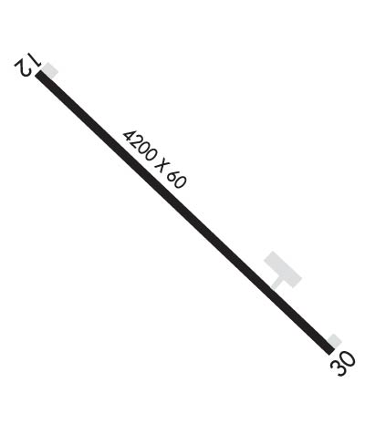
| Lat: N 4723.5 Long: W 10246.3 Elev: 2249 Var: -07 Longest Runway: 4200 | ||
| CTAF: 122.9 | ||
| ||||||||||||||||||||||||||||||||
| ||||||||||||||||||||||||||||||||
| Rwy | Rwy | |||||||
| 4200x60 | 4200' | 4200x60 | 4200' | |||||
| Runway ID | Single Wheel | Double Wheel | Double Tandem Wheel | Dual Double Wheel |
| 13/31 | 25,000 | N/A | N/A | N/A |
| These numbers are Advisory and are not limits. The Airport Manager should have more accurate Weight Limits | ||||
 Airport Diagram might not be current. | |
| Facility Name: | DUNN COUNTY WEYDAHL FLD |
| City Name: | KILLDEER |
| County: | DUNN |
| State abbrev: | ND |
| State Name: | NORTH DAKOTA |
| Ownership: | PUBLICLY OWNED |
| Use: | OPEN TO THE PUBLIC |
| Owner's Name: | DUNN COUNTY AIRPORT AUTHORITY |
| Address: | P.O. BOX 920 |
| KILLDEER, ND 58640 | |
| Owner's Phone: | (701) 260-1235 |
| Manager's Name: | GREG SYNNES |
| Address: | P.O. BOX 920 |
| Phone: | (701) 260-1235 |
| FAA Region: | GREAT LAKES |
| FAA Field Office: | DMA |
| Date | Sunrise | Sunset |
|---|---|---|
| 09/24/21 Friday | 6:40 | 18:45 |
| 09/25/21 Saturday | 6:42 | 18:43 |
| 09/26/21 Sunday | 6:43 | 18:41 |
| 09/27/21 Monday | 6:44 | 18:39 |
| 09/28/21 Tuesday | 6:46 | 18:37 |
| 09/29/21 Wednesday | 6:47 | 18:35 |
| 09/30/21 Thursday | 6:48 | 18:33 |
| 10/01/21 Friday | 6:50 | 18:31 |
| 10/02/21 Saturday | 6:51 | 18:29 |
| 10/03/21 Sunday | 6:52 | 18:27 |
| 10/04/21 Monday | 6:54 | 18:25 |
| 10/05/21 Tuesday | 6:55 | 18:23 |
| 10/06/21 Wednesday | 6:57 | 18:21 |
| 10/07/21 Thursday | 6:58 | 18:19 |
| Airport Attendance Schedule | UNATTENDED |
| Airport Status | OPERATIONAL (This Status can change at any time - please check NOTAMS) |
| Airport Lighting Schedule | ACTVT PAPI RWY 13 & 31; MIRL RWY 13/31 - CTAF |
| Airport Storage Available | Tie Downs, Hanger |
| Extra Services Available | NONE |
| Wind Indicator | YES - (lighted) |
| Control Tower | NO |
| CTAF Frequency | 122.900 |
| Unicom Frequency | |
| Rotating Beacon Color | |
| Segmented Circle | NO |
| Landing Fee | NO |
| Airport Inspected | STATE - performed by STATE AERONAUTICAL PERSONNEL |
| Inspection Date | 04/29/2020 |
| Type of Fuel Available | Grade 100LL, JET A (freeze point -40C); -10FOR 100LL 24 HR SELF SVC WITH CREDIT CARD OR CALL AMGR CELL PHONE 701-260-1235.; -A FOR JET-A 24 HR SELF SVC WITH CREDIT CARD OR CALL AMGR CELL PHONE 701-260-1235. |
| Airframe Repair Service | NONE |
| Power Plant Repair Service | NONE |
| Latitude | N4723.5 |
| Longitude | W10246.3 (ESTIMATED) |
| Arpt Elevation | 2249ft (ESTIMATED) |
| Magnetic Variation | 07E |
| 2 miles NW | of KILLDEER |
| Traffic Pattern Altitude | |
| Sectional Chart | BILLINGS |
| Operations (Reported) | Yearly | Avg. Daily |
|---|---|---|
| General Aviation Transient | 1700 | 5 |
| General Aviation Local | 300 | 1 |
| Air Taxi | 100 | 0 |
| Commerical | 0 | 0 |
| Commuter | 0 | 0 |
| Military | 50 | 0 |
| Aircraft based on Field | |
|---|---|
| General Aviation Singles | 8 |
| General Aviation Multi | 0 |
| Jet Aircraft | 0 |
| General Aviation Helicopters | 0 |
| Military Aircraft | 0 |
| Gliders | 0 |
| Ultralights | 0 |
| FSS on field | NO |
| FSS tie-in | PRINCETON |
| FSS Phone | 1-800-WX-BRIEF |
| Who issues Notams | GFK |
| Notam D service at airport | YES |
| ARTCC Name | MINNEAPOLIS |
| Airport Certification | |
| Aircraft Rescue & Firefighting Index | None |
| Airport of Entry | No |
| Custom Landing Rights | No |
| Joint Civil/Military | No |
| Military Landing rights | No |
| +500' KILLDEER MTNS 5 MILES NORTHWEST OF AIRPORT. |
| TO CONFIRM SNOW REMOVAL PHONE CONTACT MGR 701-260-1235 OR 701-290-4925 |
| FOR CD CTC MINNEAPOLIS ARTCC AT 651-463-5588. |
Airport Communications & Frequencies:
| |||||||
| Runway: 13 | Runway: 31 | ||
| Mag heading: | 126° | Mag heading: | 306° |
| Rwy Slope: | -.17% Down | Rwy Slope: | .17% Up |
| Approach: | Approach: | ||
| Pattern: | Left Traffic | Pattern: | Left Traffic |
| Markings: | NONPRECISION INSTRUMENT | Markings: | NONPRECISION INSTRUMENT |
| Marking Condition: | GOOD | Marking Condition: | GOOD |
| Arresting Dev: | Arresting Dev: | ||
| Lat & Long: | N4723.7 W10246.7 | Lat. & Long.: | N4723.2 W10245.9 |
| Elev: | 2249.0 ft. MSL | Elev: | 2242.0 ft. MSL |
| TCH: | 35 ft. AGL | TCH: | 37 ft. AGL |
| Visual Glide Path: | 3.00 degrees | Visual Glide Path: | 3.00 degrees |
| Displaced Threshold: | No | Displaced Threshold: | No |
| Touchdown Zone: | YES | Touchdown Zone: | YES |
| Touchdown Elev.: | 2249.0 feet | Touchdown Elev.: | 2249.0 feet |
| Visual Glide Slope: | 2-Light PAPI on LEFT side of Runway | Visual Glide Slope: | 2-Light PAPI on LEFT side of Runway |
| RVR Equipment: | RVR Equipment: | ||
| RVV Equipment: | NO | RVV Equipment: | NO |
| Approach Lights: | Approach Lights: | ||
| REIL: | NO | REIL: | NO |
| Centerline Lights: | NO | Centerline Lights: | NO |
| Touchdown lights: | NO | Touchdown lights: | NO |
| Runway Category: | Runway with a Visual Approach | Runway Category: | Runway with a Visual Approach |
| Declared Distances: | Declared Distances: |
Thanks for using FltPlan.com
all rights reserved © 1999-2021 by Flight Plan LLC
