
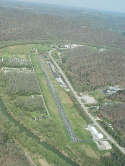
| PRESTONSBURG-COMBS FIELD PAINTSVILLE KY |
| |
| Lat: N 3744.8 Long: W 08246.7 Elev: 624 Var: +04 Longest Runway: 3070 | ||
| CTAF: 122.8 | ||
| ||||||
|
| Rwy | Rwy | |||||||
| 3070x75 | 3070' | 3070x75 | 3070' | |||||
| Runway ID | Single Wheel | Double Wheel | Double Tandem Wheel | Dual Double Wheel |
| 13/31 | 25,000 | N/A | N/A | N/A |
| These numbers are Advisory and are not limits. The Airport Manager should have more accurate Weight Limits | ||||
| FltPlan does not have IFR approach charts available for 9KY9. |
| Facility Name: | PAINTSVILLE-PRESTONSBURG-COMBS FLD |
| City Name: | PAINTSVILLE |
| County: | JOHNSON |
| State abbrev: | KY |
| State Name: | KENTUCKY |
| Ownership: | PUBLICLY OWNED |
| Use: | PRIVATE |
| Owner's Name: | PAINTSVILLE-PRESTONBURG AIR BOARD; AIR BOARD CHAIRMAN LARRY SHORT |
| Address: | 8315 KY ROUTE 321 |
| HAGER HILL, KY 41222 | |
| Owner's Phone: | 606-434-3640 |
| Manager's Name: | STANLEY HADDIX |
| Address: | 8315 KY ROUTE 321 |
| HAGER HILL, KY 41222 | |
| Phone: | (606) 434-5335 |
| FAA Region: | SOUTHERN |
| FAA Field Office: | MEM |
| Date | Sunrise | Sunset |
|---|---|---|
| 09/24/21 Friday | 7:20 | 19:25 |
| 09/25/21 Saturday | 7:21 | 19:24 |
| 09/26/21 Sunday | 7:22 | 19:22 |
| 09/27/21 Monday | 7:23 | 19:21 |
| 09/28/21 Tuesday | 7:24 | 19:19 |
| 09/29/21 Wednesday | 7:25 | 19:18 |
| 09/30/21 Thursday | 7:26 | 19:16 |
| 10/01/21 Friday | 7:26 | 19:15 |
| 10/02/21 Saturday | 7:27 | 19:13 |
| 10/03/21 Sunday | 7:28 | 19:12 |
| 10/04/21 Monday | 7:29 | 19:10 |
| 10/05/21 Tuesday | 7:30 | 19:09 |
| 10/06/21 Wednesday | 7:31 | 19:07 |
| 10/07/21 Thursday | 7:32 | 19:06 |
| Airport Attendance Schedule | 7 Days A Week 1000-1800 |
| Airport Status | OPERATIONAL (This Status can change at any time - please check NOTAMS) |
| Airport Lighting Schedule | |
| Airport Storage Available | Tie Downs, Hanger |
| Extra Services Available | Flight Instruction, Aircraft Rental |
| Wind Indicator | YES - (unlit) |
| Control Tower | NO |
| CTAF Frequency | |
| Unicom Frequency | 122.800 |
| Rotating Beacon Color | |
| Segmented Circle | YES |
| Landing Fee | NO |
| Airport Inspected | 5010-2 PRIVATE USE MAILOUT PROGRAM - performed by STATE AERONAUTICAL PERSONNEL |
| Inspection Date | 12/21/2005 |
| Type of Fuel Available | None |
| Airframe Repair Service | None |
| Power Plant Repair Service | None |
| Latitude | N3744.8 |
| Longitude | W08246.7 (ESTIMATED) |
| Arpt Elevation | 624ft (ESTIMATED) |
| Magnetic Variation | 04W |
| 4 miles SE | of PAINTSVILLE |
| Traffic Pattern Altitude | |
| Sectional Chart | CINCINNATI |
| Operations (Reported) | Yearly | Avg. Daily |
|---|---|---|
| General Aviation Transient | 3000 | 8 |
| General Aviation Local | 1500 | 4 |
| Air Taxi | 0 | 0 |
| Commerical | 0 | 0 |
| Commuter | 0 | 0 |
| Military | 0 | 0 |
| Aircraft based on Field | |
|---|---|
| General Aviation Singles | 5 |
| General Aviation Multi | 0 |
| Jet Aircraft | 0 |
| General Aviation Helicopters | 1 |
| Military Aircraft | 0 |
| Gliders | 0 |
| Ultralights | 0 |
| FSS on field | NO |
| FSS tie-in | LOUISVILLE |
| FSS Phone | 1-800-WX-BRIEF |
| Who issues Notams | |
| Notam D service at airport | No |
| ARTCC Name | INDIANAPOLIS |
| Airport Certification | |
| Aircraft Rescue & Firefighting Index | None |
| Airport of Entry | No |
| Custom Landing Rights | No |
| Joint Civil/Military | No |
| Military Landing rights | No |
| ARPT LCTD IN MTN RIVER VALLEY. DFCLT APPROACHES TO RY. |
| FOR CD CTC INDIANAPOLIS ARTCC AT 317-247-2411. |
| Runway: 13 | Runway: 31 | ||
| Mag heading: | N/A | Mag heading: | N/A |
| Approach: | Approach: | ||
| Pattern: | Left Traffic | Pattern: | Left Traffic |
| Markings: | BASIC | Markings: | BASIC |
| Marking Condition: | GOOD | Marking Condition: | GOOD |
| Arresting Dev: | Arresting Dev: | ||
| Lat & Long: | Lat. & Long.: | ||
| Elev: | N/A | Elev: | N/A |
| TCH: | TCH: | ||
| Visual Glide Path: | Visual Glide Path: | ||
| Displaced Threshold: | No | Displaced Threshold: | No |
| Touchdown Zone: | NO | Touchdown Zone: | NO |
| Touchdown Elev.: | Touchdown Elev.: | ||
| Visual Glide Slope: | Visual Glide Slope: | ||
| RVR Equipment: | RVR Equipment: | ||
| RVV Equipment: | NO | RVV Equipment: | NO |
| Approach Lights: | Approach Lights: | ||
| REIL: | NO | REIL: | NO |
| Centerline Lights: | NO | Centerline Lights: | NO |
| Touchdown lights: | NO | Touchdown lights: | NO |
| Runway Category: | Runway with a Visual Approach | Runway Category: | Runway with a Visual Approach |
| Declared Distances: | Declared Distances: | ||
| Obstructions: | TREES; RY 13 HAS 300-500 FT HILLS 3000 FT FROM RY END. | Obstructions: | TREES |
| Marked: | NOT Marked/Lighted | Marked: | NOT Marked/Lighted |
| Clearance slope: | Clearance slope: | 7:1 | |
| Obstruction height: | 20 feet AGL | Obstruction height: | 57 feet AGL |
| Dist. from runway: | 200 feet | Dist. from runway: | 610 feet |
| Centerline offset: | 60 left of centerline | Centerline offset: | 84 feet left of centerline |
| Comments: | RY 13 20 FT TREES 150 FT FROM RY END & 60 FT LEFT. | Comments: | 12 FT TREES 150 FT FROM RY END & 45 FT LEFT. |
Thanks for using FltPlan.com
all rights reserved © 1999-2021 by Flight Plan LLC