
| ELLSWORTH MUNI ELLSWORTH KS |
| |
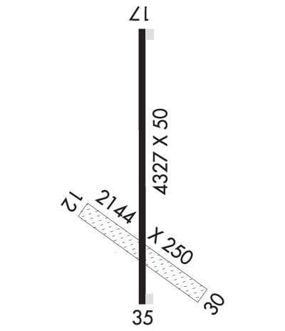
| Lat: N 3845.0 Long: W 09813.8 Elev: 1631 Var: -07 Longest Runway: 4327 | ||
| AWOS: 119.67 CTAF: 122.7 | ||
| ||||||||||||||||||||||||||||||||||||||||||||
| ||||||||||||||||||||||||||||||||||||||||||||
| ||||||||||||||||||||||||||||||||||||||||||||
| Rwy | Rwy | |||||||
| 2144x250 | 2144' | 2144x250 | 2144' | |||||
| 4327x50 | 4327' | 4327x50 | 3917' | |||||
| Runway ID | Single Wheel | Double Wheel | Double Tandem Wheel | Dual Double Wheel |
| 12/30 | N/A | N/A | N/A | N/A |
| 17/35 | N/A | N/A | N/A | N/A |
| These numbers are Advisory and are not limits. The Airport Manager should have more accurate Weight Limits | ||||
| FltPlan does not have IFR approach charts available for K9K7. |
 Airport Diagram might not be current. | |
| Facility Name: | ELLSWORTH MUNI |
| City Name: | ELLSWORTH |
| County: | ELLSWORTH |
| State abbrev: | KS |
| State Name: | KANSAS |
| Ownership: | PUBLICLY OWNED |
| Use: | OPEN TO THE PUBLIC |
| Owner's Name: | CITY OF ELLSWORTH |
| Address: | CITY HALL 1ST & K |
| ELLSWORTH, KS 67439 | |
| Owner's Phone: | 785-472-5566 |
| Manager's Name: | SCOTT MOORE- CITY ADMIN |
| Address: | CITY HALL |
| ELLSWORTH, KS 67439 | |
| Phone: | 785-472-5566 |
| FAA Region: | CENTRAL |
| FAA Field Office: | NONE |
| Date | Sunrise | Sunset |
|---|---|---|
| 09/24/21 Friday | 7:22 | 19:27 |
| 09/25/21 Saturday | 7:23 | 19:25 |
| 09/26/21 Sunday | 7:24 | 19:24 |
| 09/27/21 Monday | 7:25 | 19:22 |
| 09/28/21 Tuesday | 7:26 | 19:21 |
| 09/29/21 Wednesday | 7:27 | 19:19 |
| 09/30/21 Thursday | 7:28 | 19:18 |
| 10/01/21 Friday | 7:29 | 19:16 |
| 10/02/21 Saturday | 7:30 | 19:14 |
| 10/03/21 Sunday | 7:30 | 19:13 |
| 10/04/21 Monday | 7:31 | 19:11 |
| 10/05/21 Tuesday | 7:32 | 19:10 |
| 10/06/21 Wednesday | 7:33 | 19:08 |
| 10/07/21 Thursday | 7:34 | 19:07 |
| Airport Attendance Schedule | UNATTENDED |
| Airport Status | OPERATIONAL (This Status can change at any time - please check NOTAMS) |
| Airport Lighting Schedule | ACTVT MIRL RY 17/35 & TRIL RY 35 - CTAF. |
| Airport Storage Available | Tie Downs |
| Extra Services Available | Crop Dusting |
| Wind Indicator | YES - (unlit) |
| Control Tower | NO |
| CTAF Frequency | 122.700 |
| Unicom Frequency | 122.700 |
| Rotating Beacon Color | CLEAR-GREEN (Light Land Airport) |
| Segmented Circle | NO |
| Landing Fee | NO |
| Airport Inspected | STATE - performed by STATE AERONAUTICAL PERSONNEL |
| Inspection Date | 09/12/2018 |
| Type of Fuel Available | Grade 100LL; -10FOR FUEL AFT HRS CALL 785-472-4416. FUEL ALSO AVBL 24 HRS BY CREDIT CARD. |
| Airframe Repair Service | NONE |
| Power Plant Repair Service | NONE |
| Latitude | N3845.0 |
| Longitude | W09813.8 (ESTIMATED) |
| Arpt Elevation | 1630ft (SURVEYED) |
| Magnetic Variation | 07E |
| 1 miles N | of ELLSWORTH |
| Traffic Pattern Altitude | |
| Sectional Chart | WICHITA |
| Operations (Reported) | Yearly | Avg. Daily |
|---|---|---|
| General Aviation Transient | 6000 | 16 |
| General Aviation Local | 14000 | 38 |
| Air Taxi | 0 | 0 |
| Commerical | 0 | 0 |
| Commuter | 0 | 0 |
| Military | 75 | 0 |
| Aircraft based on Field | |
|---|---|
| General Aviation Singles | 15 |
| General Aviation Multi | 0 |
| Jet Aircraft | 0 |
| General Aviation Helicopters | 0 |
| Military Aircraft | 0 |
| Gliders | 0 |
| Ultralights | 0 |
| FSS on field | NO |
| FSS tie-in | WICHITA |
| FSS Phone | 1-800-WX-BRIEF |
| Who issues Notams | ICT |
| Notam D service at airport | YES |
| ARTCC Name | KANSAS CITY |
| Airport Certification | |
| Aircraft Rescue & Firefighting Index | None |
| Airport of Entry | No |
| Custom Landing Rights | No |
| Joint Civil/Military | No |
| Military Landing rights | No |
| NATIONAL PLAN OF INTEGRATED AIRPORT SYSTEMS (NPIAS) |
| IN APCH AREA TO RY 35 ARE FENCES; CLUSTER LIGHTS & TOWERS. |
| ARPT PUBLIC PHONE NUMBER 785-472-5608. |
| FOR CD CTC KANSAS CITY ARTCC AT 913-254-8508. |
| Runway: 12 | Runway: 30 | ||
| Mag heading: | N/A | Mag heading: | N/A |
| Rwy Slope: | -.32% Down | Rwy Slope: | .32% Up |
| Approach: | Approach: | ||
| Pattern: | Left Traffic | Pattern: | Left Traffic |
| Markings: | Markings: | ||
| Marking Condition: | Marking Condition: | ||
| Arresting Dev: | Arresting Dev: | ||
| Lat & Long: | N3845.0 W09814.0 | Lat. & Long.: | N3844.8 W09813.7 |
| Elev: | 1607.3 ft. MSL | Elev: | 1600.5 ft. MSL |
| TCH: | TCH: | ||
| Visual Glide Path: | Visual Glide Path: | ||
| Displaced Threshold: | No | Displaced Threshold: | No |
| Touchdown Zone: | YES | Touchdown Zone: | YES |
| Touchdown Elev.: | 1607.3 feet | Touchdown Elev.: | 1607.3 feet |
| Visual Glide Slope: | Visual Glide Slope: | ||
| RVR Equipment: | RVR Equipment: | ||
| RVV Equipment: | NO | RVV Equipment: | NO |
| Approach Lights: | Approach Lights: | ||
| REIL: | NO | REIL: | NO |
| Centerline Lights: | NO | Centerline Lights: | NO |
| Touchdown lights: | NO | Touchdown lights: | NO |
| Runway Category: | Runway with a Visual Approach | Runway Category: | Runway with a Visual Approach |
| Declared Distances: | Declared Distances: |
| Runway: 17 | Runway: 35 | ||
| Mag heading: | N/A | Mag heading: | N/A |
| Rwy Slope: | -.52% Down | Rwy Slope: | .52% Up |
| Approach: | Approach: | ||
| Pattern: | Left Traffic | Pattern: | Left Traffic |
| Markings: | NUMBERS ONLY | Markings: | NUMBERS ONLY |
| Marking Condition: | GOOD | Marking Condition: | GOOD |
| Arresting Dev: | Arresting Dev: | ||
| Lat & Long: | N3845.5 W09813.8 | Lat. & Long.: | N3844.8 W09813.8 |
| Elev: | 1630.5 ft. MSL | Elev: | 1608.0 ft. MSL |
| TCH: | TCH: | ||
| Visual Glide Path: | Visual Glide Path: | ||
| Displaced Threshold: | No | Displaced Threshold: | 410 feet |
| Touchdown Zone: | YES | Touchdown Zone: | YES |
| Touchdown Elev.: | 1630.5 feet | Touchdown Elev.: | 1622.6 feet |
| Visual Glide Slope: | Visual Glide Slope: | TRI-COLOR VASI ON LEFT SIDE OF RUNWAY; TRIL OPER NIGHT ONLY. | |
| RVR Equipment: | RVR Equipment: | ||
| RVV Equipment: | NO | RVV Equipment: | NO |
| Approach Lights: | Approach Lights: | ||
| REIL: | NO | REIL: | NO |
| Centerline Lights: | NO | Centerline Lights: | NO |
| Touchdown lights: | NO | Touchdown lights: | NO |
| Runway Category: | Runway with a Visual Approach | Runway Category: | Runway with a Visual Approach |
| Declared Distances: | Declared Distances: | ||
| Obstructions: | Obstructions: | POLE | |
| Marked: | Marked: | LIGHTED | |
| Clearance slope: | 50:1 | Clearance slope: | 18:1; 33:1 TO DSPLCD THR. |
| Obstruction height: | Obstruction height: | 40 feet AGL | |
| Dist. from runway: | Dist. from runway: | 938 feet | |
| Centerline offset: | Centerline offset: | ||
| Comments: | Comments: |
Thanks for using FltPlan.com
all rights reserved © 1999-2021 by Flight Plan LLC