| AKRON AKRON NY |
| |
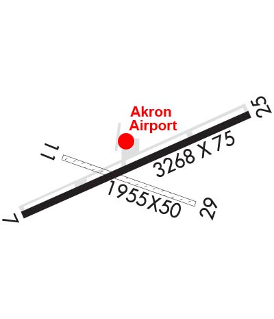
| Lat: N 4301.3 Long: W 07829.0 Elev: 840 Var: +11 Longest Runway: 3268 | ||
| CTAF: 122.72 | ||
| |||||||||||||||||||||||||||||||||||||||||||||||||||||||||||||
| |||||||||||||||||||||||||||||||||||||||||||||||||||||||||||||
| Rwy | Rwy | |||||||
| 3268x75 | 3268' | 3268x75 | 3268' | |||||
| Runway ID | Single Wheel | Double Wheel | Double Tandem Wheel | Dual Double Wheel |
| 07/25 | 8,000 | N/A | N/A | N/A |
| These numbers are Advisory and are not limits. The Airport Manager should have more accurate Weight Limits | ||||
 Airport Diagram might not be current. | |
| Facility Name: | AKRON/JESSON FLD |
| City Name: | AKRON |
| County: | ERIE |
| State abbrev: | NY |
| State Name: | NEW YORK |
| Ownership: | PRIVATELY OWNED |
| Use: | OPEN TO THE PUBLIC |
| Owner's Name: | CHRISTIAN AIRMEN INC. |
| Address: | PO BOX 126 |
| AKRON, NY 14001 | |
| Owner's Phone: | 716-542-4607 |
| Manager's Name: | PETER TREICHLER |
| Address: | BOX 126, JOHN ST. |
| AKRON, NY 14001 | |
| Phone: | 716-542-4607 |
| FAA Region: | EASTERN |
| FAA Field Office: | NYC |
| Date | Sunrise | Sunset |
|---|---|---|
| 06/08/26 Monday | 5:35 | 20:51 |
| 06/09/26 Tuesday | 5:35 | 20:52 |
| 06/10/26 Wednesday | 5:34 | 20:52 |
| 06/11/26 Thursday | 5:34 | 20:53 |
| 06/12/26 Friday | 5:34 | 20:53 |
| 06/13/26 Saturday | 5:34 | 20:54 |
| 06/14/26 Sunday | 5:34 | 20:54 |
| 06/15/26 Monday | 5:34 | 20:55 |
| 06/16/26 Tuesday | 5:34 | 20:55 |
| 06/17/26 Wednesday | 5:34 | 20:56 |
| 06/18/26 Thursday | 5:34 | 20:56 |
| 06/19/26 Friday | 5:34 | 20:56 |
| 06/20/26 Saturday | 5:34 | 20:56 |
| 06/21/26 Sunday | 5:35 | 20:57 |
| Airport Attendance Schedule | UNATND; FOR ATNDTC CALL 716-864-5004, ALLEN KIDDER. |
| Airport Status | OPERATIONAL (This Status can change at any time - please check NOTAMS) |
| Airport Lighting Schedule | ACTVT PAPI RWY 07 & 25; REIL RWY 25; MIRL RWY 07/25 - CTAF. |
| Airport Storage Available | Tie Downs |
| Extra Services Available | Flight Instruction, Aircraft Rental |
| Wind Indicator | YES - (unlit) |
| Control Tower | NO |
| CTAF Frequency | 122.725 |
| Unicom Frequency | 122.725 |
| Rotating Beacon Color | WG |
| Segmented Circle | NO |
| Landing Fee | NO |
| Airport Inspected | STATE - performed by PRIVATE CONTRACT PERSONNEL |
| Inspection Date | 07/14/2024 |
| Type of Fuel Available | Grade 100LL; -10FUEL 24 HR SELF SVC. |
| Airframe Repair Service | NONE |
| Power Plant Repair Service | NONE |
| Latitude | N4301.3 |
| Longitude | W07829.0 (ESTIMATED) |
| Arpt Elevation | 839ft (SURVEYED) |
| Magnetic Variation | 11W |
| 1 miles E | of AKRON |
| Traffic Pattern Altitude | |
| Sectional Chart | DETROIT |
| Operations (Reported) | Yearly | Avg. Daily |
|---|---|---|
| General Aviation Transient | 0 | 0 |
| General Aviation Local | 0 | 0 |
| Air Taxi | 0 | 0 |
| Commerical | 0 | 0 |
| Commuter | 0 | 0 |
| Military | 0 | 0 |
| Aircraft based on Field | |
|---|---|
| General Aviation Singles | 0 |
| General Aviation Multi | 0 |
| Jet Aircraft | 0 |
| General Aviation Helicopters | 0 |
| Military Aircraft | 0 |
| Gliders | 0 |
| Ultralights | 0 |
| FSS on field | NO |
| FSS tie-in | BUFFALO |
| FSS Phone | 1-800-WX-BRIEF |
| Who issues Notams | BUF |
| Notam D service at airport | YES |
| ARTCC Name | CLEVELAND |
| Airport Certification | |
| Aircraft Rescue & Firefighting Index | None |
| Airport of Entry | No |
| Custom Landing Rights | No |
| Joint Civil/Military | No |
| Military Landing rights | No |
| NATIONAL PLAN OF INTEGRATED AIRPORT SYSTEMS (NPIAS) |
| PARL TWY LGTD AND 35 FT WIDE. |
| RWY 25 NOISE ABATEMENT - MNTN RWY HDG TIL 3/4 MI BYD DEP END RWY 25 BFR TURNING. |
| FOR CD CTC CLEVELAND ARTCC AT 440-774-0490. |
Airport Communications & Frequencies:
| ||||||||||||||
| Runway: 07 | Runway: 25 | ||
| Mag heading: | 71° | Mag heading: | 251° |
| Rwy Slope: | .30% Up | Rwy Slope: | -.30% Down |
| Approach: | Approach: | ||
| Pattern: | Left Traffic | Pattern: | Left Traffic |
| Markings: | NONPRECISION INSTRUMENT | Markings: | NONPRECISION INSTRUMENT |
| Marking Condition: | FAIR | Marking Condition: | FAIR |
| Arresting Dev: | Arresting Dev: | ||
| Lat & Long: | N4301.1 W07829.3 | Lat. & Long.: | N4301.4 W07828.6 |
| Elev: | 829.8 ft. MSL | Elev: | 839.7 ft. MSL |
| TCH: | 54 ft. AGL | TCH: | 55 ft. AGL |
| Visual Glide Path: | 4.00 degrees | Visual Glide Path: | 4.00 degrees |
| Displaced Threshold: | No | Displaced Threshold: | No |
| Touchdown Zone: | YES | Touchdown Zone: | YES |
| Touchdown Elev.: | 839.0 feet | Touchdown Elev.: | 839.7 feet |
| Visual Glide Slope: | 2-Light PAPI on LEFT side of Runway; UNUSBL BYD 7 DEGS RIGHT OF CNTRLN. | Visual Glide Slope: | 2-Light PAPI on LEFT side of Runway |
| RVR Equipment: | RVR Equipment: | ||
| RVV Equipment: | NO | RVV Equipment: | NO |
| Approach Lights: | Approach Lights: | ||
| REIL: | NO | REIL: | YES |
| Centerline Lights: | NO | Centerline Lights: | NO |
| Touchdown lights: | NO | Touchdown lights: | NO |
| Runway Category: | Runway with a Non-precision Approach | Runway Category: | Runway with a Non-precision Approach |
| Declared Distances: | Declared Distances: | ||
| Obstructions: | TREES | Obstructions: | TREES |
| Marked: | NOT Marked/Lighted | Marked: | NOT Marked/Lighted |
| Clearance slope: | NMRS TREES IN THE APCH. | Clearance slope: | 1:1 |
| Obstruction height: | 50 feet AGL | Obstruction height: | 40 feet AGL |
| Dist. from runway: | 201 feet | Dist. from runway: | 240 feet |
| Centerline offset: | 185 right of centerline | Centerline offset: | 240 feet left of centerline |
| Comments: | 8 FT FENCE: 54 FT DSTC, 220 FT R. | Comments: | 8 FT SIGN: 11 FT DSTC, 249 FT R; 8 FT FENCE 130-199 FT D. |
Thanks for using FltPlan.com
all rights reserved © 1999-2026 by Flight Plan LLC