
| BUFFALO AIRFIELD BUFFALO NY |
| |
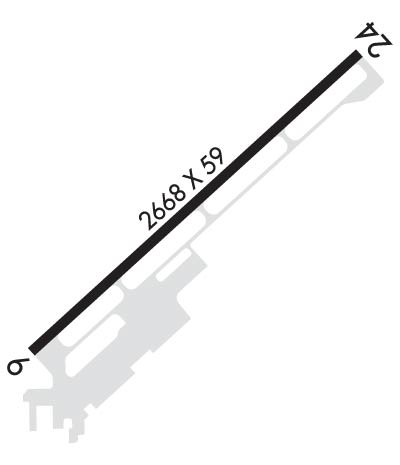
| Lat: N 4251.7 Long: W 07843.0 Elev: 670 Var: +11 Longest Runway: 2666 | ||
| CTAF: 122.97 | ||
| ||||||
|
| Rwy | Rwy | |||||||
| 2666x60 | 2598' | 2666x60 | 2666' | |||||
| Runway ID | Single Wheel | Double Wheel | Double Tandem Wheel | Dual Double Wheel |
| 06/24 | 8,000 | N/A | N/A | N/A |
| These numbers are Advisory and are not limits. The Airport Manager should have more accurate Weight Limits | ||||
 Airport Diagram might not be current. | |
| Facility Name: | BUFFALO AIRFIELD |
| City Name: | BUFFALO |
| County: | ERIE |
| State abbrev: | NY |
| State Name: | NEW YORK |
| Ownership: | PRIVATELY OWNED |
| Use: | OPEN TO THE PUBLIC |
| Owner's Name: | L. J. PEZZANITE |
| Address: | 4500 CLINTON ST |
| WEST SENECA, NY 14224 | |
| Owner's Phone: | 716-668-4900 |
| Manager's Name: | JOSEPH R. PEZZANITE |
| Address: | 4500 CLINTON ST |
| WEST SENECA, NY 14224 | |
| Phone: | 716-560-1836 |
| FAA Region: | EASTERN |
| FAA Field Office: | NYC |
| Date | Sunrise | Sunset |
|---|---|---|
| 06/08/26 Monday | 5:36 | 20:52 |
| 06/09/26 Tuesday | 5:36 | 20:52 |
| 06/10/26 Wednesday | 5:36 | 20:53 |
| 06/11/26 Thursday | 5:36 | 20:53 |
| 06/12/26 Friday | 5:36 | 20:54 |
| 06/13/26 Saturday | 5:36 | 20:54 |
| 06/14/26 Sunday | 5:36 | 20:55 |
| 06/15/26 Monday | 5:36 | 20:55 |
| 06/16/26 Tuesday | 5:36 | 20:56 |
| 06/17/26 Wednesday | 5:36 | 20:56 |
| 06/18/26 Thursday | 5:36 | 20:56 |
| 06/19/26 Friday | 5:36 | 20:57 |
| 06/20/26 Saturday | 5:36 | 20:57 |
| 06/21/26 Sunday | 5:36 | 20:57 |
| Airport Attendance Schedule | 7 Days A Week ON CALL; CALL AMGR. |
| Airport Status | OPERATIONAL (This Status can change at any time - please check NOTAMS) |
| Airport Lighting Schedule | ACTVT REIL RWYS 06 & 24; MIRL RWY 06/24 - CTAF. |
| Airport Storage Available | Tie Downs, Hanger |
| Extra Services Available | NONE |
| Wind Indicator | YES - (lighted) |
| Control Tower | NO |
| CTAF Frequency | 122.975 |
| Unicom Frequency | 122.975 |
| Rotating Beacon Color | WG |
| Segmented Circle | YES |
| Landing Fee | NO |
| Airport Inspected | STATE - performed by PRIVATE CONTRACT PERSONNEL |
| Inspection Date | 07/14/2024 |
| Type of Fuel Available | Grade 100LL, JET A; -1024 HRS SELF SVC FUEL. |
| Airframe Repair Service | NONE |
| Power Plant Repair Service | NONE |
| Latitude | N4251.7 |
| Longitude | W07843.0 (ESTIMATED) |
| Arpt Elevation | 669ft (SURVEYED) |
| Magnetic Variation | 11W |
| 6 miles SE | of BUFFALO |
| Traffic Pattern Altitude | 830 |
| Sectional Chart | DETROIT |
| Operations (Reported) | Yearly | Avg. Daily |
|---|---|---|
| General Aviation Transient | 0 | 0 |
| General Aviation Local | 0 | 0 |
| Air Taxi | 0 | 0 |
| Commerical | 0 | 0 |
| Commuter | 0 | 0 |
| Military | 0 | 0 |
| Aircraft based on Field | |
|---|---|
| General Aviation Singles | 0 |
| General Aviation Multi | 0 |
| Jet Aircraft | 0 |
| General Aviation Helicopters | 0 |
| Military Aircraft | 0 |
| Gliders | 0 |
| Ultralights | 0 |
| FSS on field | NO |
| FSS tie-in | BUFFALO |
| FSS Phone | 1-800-WX-BRIEF |
| Who issues Notams | BUF |
| Notam D service at airport | YES |
| ARTCC Name | CLEVELAND |
| Airport Certification | |
| Aircraft Rescue & Firefighting Index | None |
| Airport of Entry | No |
| Custom Landing Rights | No |
| Joint Civil/Military | No |
| Military Landing rights | No |
| NATIONAL PLAN OF INTEGRATED AIRPORT SYSTEMS (NPIAS) |
| ASSURANCES PURSUANT TO TITLE VI, CIVIL RIGHTS ACT OF 1964 |
| DEER ON & INVOF ARPT. |
| RWY 6 & 24: NMRS TREES IN APCH. |
| FOR CD CTC CLEVELAND ARTCC AT 440-774-0490. |
| HOLD LINE MKGS POOR-NONE. |
Airport Communications & Frequencies:
| ||||||||||||||
| Runway: 06 | Runway: 24 | ||
| Mag heading: | 59° | Mag heading: | 239° |
| Rwy Slope: | .29% Up | Rwy Slope: | -.29% Down |
| Approach: | Approach: | ||
| Pattern: | Left Traffic | Pattern: | Left Traffic |
| Markings: | NONPRECISION INSTRUMENT | Markings: | NONPRECISION INSTRUMENT |
| Marking Condition: | FAIR | Marking Condition: | FAIR |
| Arresting Dev: | Arresting Dev: | ||
| Lat & Long: | N4251.6 W07843.2 | Lat. & Long.: | N4251.9 W07842.8 |
| Elev: | 661.8 ft. MSL | Elev: | 669.5 ft. MSL |
| TCH: | 40 ft. AGL | TCH: | 28 ft. AGL |
| Visual Glide Path: | 3.00 degrees | Visual Glide Path: | 3.00 degrees |
| Displaced Threshold: | 68 feet | Displaced Threshold: | No |
| Touchdown Zone: | YES | Touchdown Zone: | YES |
| Touchdown Elev.: | 669.6 feet | Touchdown Elev.: | 669.6 feet |
| Visual Glide Slope: | 2-Light PAPI on RIGHT side of Runway | Visual Glide Slope: | 2-Light PAPI on LEFT side of Runway |
| RVR Equipment: | RVR Equipment: | ||
| RVV Equipment: | NO | RVV Equipment: | NO |
| Approach Lights: | Approach Lights: | ||
| REIL: | YES | REIL: | YES |
| Centerline Lights: | NO | Centerline Lights: | NO |
| Touchdown lights: | NO | Touchdown lights: | NO |
| Runway Category: | Runway with a Non-precision Approach | Runway Category: | Runway with a Non-precision Approach |
| Declared Distances: | Declared Distances: | ||
| Obstructions: | TREES | Obstructions: | TREES |
| Marked: | NOT Marked/Lighted | Marked: | NOT Marked/Lighted |
| Clearance slope: | CNTLG OBSTN EXCEEDS 45 DEG SLP. | Clearance slope: | |
| Obstruction height: | 15 feet AGL | Obstruction height: | 19 feet AGL |
| Dist. from runway: | 201 feet | Dist. from runway: | 201 feet |
| Centerline offset: | 32 left of centerline | Centerline offset: | 250 feet right of centerline |
| Comments: | 40 FT TREES; UP TO 199 FT DSTC. | Comments: | 15 FT TREES; UP TO 199 FT DSTC. |
Thanks for using FltPlan.com
all rights reserved © 1999-2026 by Flight Plan LLC
