
| HASTINGS HASTINGS MI |
| |
| Lat: N 4239.8 Long: W 08520.7 Elev: 800 Var: +06 Longest Runway: 5003 | ||
| CTAF: 123.07 | ||
| ||||||
|
| Rwy | Rwy | |||||||
| 2380x170 | 2189' | 2380x170 | 2006' | |||||
| 5003x75 | 4762' | 5003x75 | 4752' | |||||
| 1952x200 | 1952' | 1952x200 | 1952' | |||||
| Runway ID | Single Wheel | Double Wheel | Double Tandem Wheel | Dual Double Wheel |
| 09/27 | N/A | N/A | N/A | N/A |
| 12/30 | 20,000 | N/A | N/A | N/A |
| 18/36 | N/A | N/A | N/A | N/A |
| These numbers are Advisory and are not limits. The Airport Manager should have more accurate Weight Limits | ||||
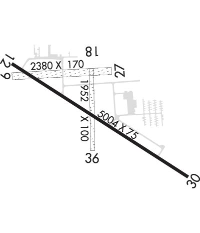 Airport Diagram might not be current. | |
| Facility Name: | HASTINGS |
| City Name: | HASTINGS |
| County: | BARRY |
| State abbrev: | MI |
| State Name: | MICHIGAN |
| Ownership: | PUBLICLY OWNED |
| Use: | OPEN TO THE PUBLIC |
| Owner's Name: | HASTINGS CITY-BARRY CO ARPT COMM |
| Address: | 220 W. STATE ST. |
| HASTINGS, MI 49058 | |
| Owner's Phone: | 269-945-1284 |
| Manager's Name: | MARK NOTEBOOM; ASST MGR MARK ANDERSON 269-804-9588 |
| Address: | 2505 MURPHY DR. |
| HASTINGS, MI 49058 | |
| Phone: | 269-945-6306; CELL 269-838-5874 |
| FAA Region: | GREAT LAKES |
| FAA Field Office: | DET |
| Date | Sunrise | Sunset |
|---|---|---|
| 09/24/21 Friday | 7:31 | 19:36 |
| 09/25/21 Saturday | 7:32 | 19:34 |
| 09/26/21 Sunday | 7:33 | 19:32 |
| 09/27/21 Monday | 7:34 | 19:30 |
| 09/28/21 Tuesday | 7:35 | 19:28 |
| 09/29/21 Wednesday | 7:36 | 19:27 |
| 09/30/21 Thursday | 7:37 | 19:25 |
| 10/01/21 Friday | 7:38 | 19:23 |
| 10/02/21 Saturday | 7:39 | 19:21 |
| 10/03/21 Sunday | 7:40 | 19:20 |
| 10/04/21 Monday | 7:42 | 19:18 |
| 10/05/21 Tuesday | 7:43 | 19:16 |
| 10/06/21 Wednesday | 7:44 | 19:14 |
| 10/07/21 Thursday | 7:45 | 19:13 |
| Airport Attendance Schedule | 7 Days A Week IREG |
| Airport Status | OPERATIONAL (This Status can change at any time - please check NOTAMS) |
| Airport Lighting Schedule | ACTVT MIRL RY 12/30, PAPI RY 12 & RY 30, REIL RY 12 & RY 30 - CTAF. |
| Airport Storage Available | Tie Downs, Hanger |
| Extra Services Available | Flight Instruction |
| Wind Indicator | YES - (lighted) |
| Control Tower | NO |
| CTAF Frequency | 123.075 |
| Unicom Frequency | 123.075 |
| Rotating Beacon Color | CLEAR-GREEN (Light Land Airport) |
| Segmented Circle | YES |
| Landing Fee | NO |
| Airport Inspected | STATE - performed by STATE AERONAUTICAL PERSONNEL |
| Inspection Date | 09/17/2019 |
| Type of Fuel Available | Grade 100LL, JET A |
| Airframe Repair Service | MAJOR |
| Power Plant Repair Service | MAJOR |
| Latitude | N4239.8 |
| Longitude | W08520.7 (ESTIMATED) |
| Arpt Elevation | 800ft (SURVEYED) |
| Magnetic Variation | 06W |
| 3 miles W | of HASTINGS |
| Traffic Pattern Altitude | 800 |
| Sectional Chart | CHICAGO |
| Operations (Reported) | Yearly | Avg. Daily |
|---|---|---|
| General Aviation Transient | 5000 | 14 |
| General Aviation Local | 5000 | 14 |
| Air Taxi | 0 | 0 |
| Commerical | 0 | 0 |
| Commuter | 0 | 0 |
| Military | 1500 | 4 |
| Aircraft based on Field | |
|---|---|
| General Aviation Singles | 65 |
| General Aviation Multi | 8 |
| Jet Aircraft | 1 |
| General Aviation Helicopters | 6 |
| Military Aircraft | 0 |
| Gliders | 1 |
| Ultralights | 0 |
| FSS on field | NO |
| FSS tie-in | LANSING |
| FSS Phone | 1-800-WX-BRIEF |
| Who issues Notams | LAN |
| Notam D service at airport | YES |
| ARTCC Name | CHICAGO |
| Airport Certification | |
| Aircraft Rescue & Firefighting Index | None |
| Airport of Entry | No |
| Custom Landing Rights | No |
| Joint Civil/Military | No |
| Military Landing rights | YES |
| NATIONAL PLAN OF INTEGRATED AIRPORT SYSTEMS (NPIAS) |
| GRANT AGREEMENTS UNDER FAAP/ADAP/AIP |
| ASSURANCES PURSUANT TO TITLE VI, CIVIL RIGHTS ACT OF 1964 |
| LRG FLOCKS OF LRG BIRDS ON & INVOF ARPT. |
| FOR CD CTC GREAT LAKES APCH AT 269-459-3344, WHEN APCH CLSD CTC CHICAGO ARTCC AT 630-906-8921. |
Airport Communications & Frequencies:
| |||||||||||||||||
| Runway: 09 | Runway: 27 | ||
| Mag heading: | 93° | Mag heading: | 273° |
| Rwy Slope: | .15% Up | Rwy Slope: | -.15% Down |
| Approach: | Approach: | ||
| Pattern: | Left Traffic | Pattern: | Left Traffic |
| Markings: | Markings: | ||
| Marking Condition: | RWY 09/27 & RWY 18/36 MKD WITH 3 FT YELLOW CONES. | Marking Condition: | |
| Arresting Dev: | Arresting Dev: | ||
| Lat & Long: | N4239.9 W08521.2 | Lat. & Long.: | N4239.9 W08520.6 |
| Elev: | 794.7 ft. MSL | Elev: | 798.2 ft. MSL |
| TCH: | TCH: | ||
| Visual Glide Path: | Visual Glide Path: | ||
| Displaced Threshold: | 191 feet | Displaced Threshold: | 374 feet |
| Touchdown Zone: | YES | Touchdown Zone: | YES |
| Touchdown Elev.: | 798.9 feet | Touchdown Elev.: | 798.1 feet |
| Visual Glide Slope: | Visual Glide Slope: | ||
| RVR Equipment: | RVR Equipment: | ||
| RVV Equipment: | NO | RVV Equipment: | NO |
| Approach Lights: | Approach Lights: | ||
| REIL: | NO | REIL: | NO |
| Centerline Lights: | NO | Centerline Lights: | NO |
| Touchdown lights: | NO | Touchdown lights: | NO |
| Runway Category: | Runway with a Visual Approach | Runway Category: | Runway with a Visual Approach |
| Declared Distances: | Declared Distances: | ||
| Obstructions: | TREES | Obstructions: | TREES |
| Marked: | NOT Marked/Lighted | Marked: | NOT Marked/Lighted |
| Clearance slope: | 16:1 | Clearance slope: | 19:1; APCH RATIO 20:1 AT DSPLCD THLD. |
| Obstruction height: | 43 feet AGL | Obstruction height: | 72 feet AGL |
| Dist. from runway: | 704 feet | Dist. from runway: | 1400 feet |
| Centerline offset: | 115 right of centerline | Centerline offset: | |
| Comments: | Comments: |
| Runway: 12 | Runway: 30 | ||
| Mag heading: | 128° | Mag heading: | 308° |
| Rwy Slope: | -.01% Down | Rwy Slope: | .01% Up |
| Approach: | Approach: | ||
| Pattern: | Left Traffic | Pattern: | Left Traffic |
| Markings: | NONPRECISION INSTRUMENT | Markings: | NONPRECISION INSTRUMENT |
| Marking Condition: | GOOD | Marking Condition: | GOOD |
| Arresting Dev: | Arresting Dev: | ||
| Lat & Long: | N4240.0 W08521.2 | Lat. & Long.: | N4239.5 W08520.2 |
| Elev: | 797.1 ft. MSL | Elev: | 796.7 ft. MSL |
| TCH: | 34 ft. AGL | TCH: | 43 ft. AGL |
| Visual Glide Path: | 4.00 degrees | Visual Glide Path: | 3.00 degrees |
| Displaced Threshold: | 241 feet | Displaced Threshold: | 251 feet |
| Touchdown Zone: | YES | Touchdown Zone: | YES |
| Touchdown Elev.: | 799.5 feet | Touchdown Elev.: | 799.5 feet |
| Visual Glide Slope: | 4-Light PAPI on RIGHT side of Runway | Visual Glide Slope: | 4-Light PAPI on LEFT side of Runway; PAPI UNUSBL BYD 5 DEGS LEFT OF CNTRLN. |
| RVR Equipment: | RVR Equipment: | ||
| RVV Equipment: | NO | RVV Equipment: | NO |
| Approach Lights: | Approach Lights: | ||
| REIL: | YES | REIL: | YES |
| Centerline Lights: | NO | Centerline Lights: | NO |
| Touchdown lights: | NO | Touchdown lights: | NO |
| Runway Category: | Runway with a Non-precision Approach | Runway Category: | Runway with a Non-precision Approach |
| Declared Distances: | Declared Distances: | ||
| Obstructions: | TREES | Obstructions: | TREES |
| Marked: | NOT Marked/Lighted | Marked: | NOT Marked/Lighted |
| Clearance slope: | 15:1; APCH RATIO 24:1 AT DSPLCD THLD. | Clearance slope: | |
| Obstruction height: | 51 feet AGL | Obstruction height: | 29 feet AGL |
| Dist. from runway: | 996 feet | Dist. from runway: | 205 feet |
| Centerline offset: | 350 right of centerline | Centerline offset: | 320 feet left of centerline |
| Comments: | 10 FT BRUSH, 150-200 FT DIST, 230-250 FT R. | Comments: |
| Runway: 18 | Runway: 36 | ||
| Mag heading: | 185° | Mag heading: | 5° |
| Rwy Slope: | .06% Up | Rwy Slope: | -.06% Down |
| Approach: | Approach: | ||
| Pattern: | Left Traffic | Pattern: | Left Traffic |
| Markings: | Markings: | ||
| Marking Condition: | Marking Condition: | ||
| Arresting Dev: | Arresting Dev: | ||
| Lat & Long: | N4239.9 W08520.7 | Lat. & Long.: | N4239.6 W08520.7 |
| Elev: | 797.0 ft. MSL | Elev: | 798.1 ft. MSL |
| TCH: | TCH: | ||
| Visual Glide Path: | Visual Glide Path: | ||
| Displaced Threshold: | No | Displaced Threshold: | No |
| Touchdown Zone: | YES | Touchdown Zone: | YES |
| Touchdown Elev.: | 800.4 feet | Touchdown Elev.: | 800.4 feet |
| Visual Glide Slope: | Visual Glide Slope: | ||
| RVR Equipment: | RVR Equipment: | ||
| RVV Equipment: | NO | RVV Equipment: | NO |
| Approach Lights: | Approach Lights: | ||
| REIL: | NO | REIL: | NO |
| Centerline Lights: | NO | Centerline Lights: | NO |
| Touchdown lights: | NO | Touchdown lights: | NO |
| Runway Category: | Runway with a Visual Approach | Runway Category: | Runway with a Visual Approach |
| Declared Distances: | Declared Distances: | ||
| Obstructions: | TREES | Obstructions: | TREES |
| Marked: | NOT Marked/Lighted | Marked: | NOT Marked/Lighted |
| Clearance slope: | 14:1 | Clearance slope: | 10:1; APCH RATIO 25:1 AT DSPLCD THLD, 20:1 BASED ON STRAIGHT OUT. |
| Obstruction height: | 53 feet AGL | Obstruction height: | 18 feet AGL |
| Dist. from runway: | 748 feet | Dist. from runway: | 197 feet |
| Centerline offset: | 125 right of centerline | Centerline offset: | |
| Comments: | Comments: |
Thanks for using FltPlan.com
all rights reserved © 1999-2021 by Flight Plan LLC
