
| BARWICK LAFAYETTE LAFAYETTE GA |
| |
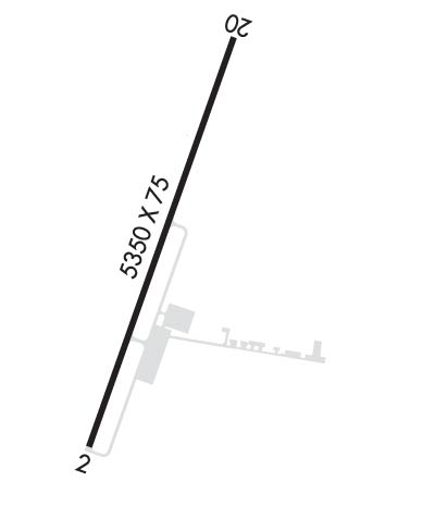
| Lat: N 3441.3 Long: W 08517.4 Elev: 776 Var: +03 Longest Runway: 5415 | ||
| AWOS: 119.77 CTAF: 122.8 | ||
| ||||||||||||||||||||||||||||||||||||||||||||
| ||||||||||||||||||||||||||||||||||||||||||||
| ||||||||||||||||||||||||||||||||||||||||||||
| Rwy | Rwy | |||||||
| 5415x75 | 5350' | 5415x75 | 4966' | |||||
| Runway ID | Single Wheel | Double Wheel | Double Tandem Wheel | Dual Double Wheel |
| 02/20 | 20,000 | N/A | N/A | N/A |
| These numbers are Advisory and are not limits. The Airport Manager should have more accurate Weight Limits | ||||
 Airport Diagram might not be current. | |
| Facility Name: | BARWICK LAFAYETTE |
| City Name: | LAFAYETTE |
| County: | WALKER |
| State abbrev: | GA |
| State Name: | GEORGIA |
| Ownership: | PUBLICLY OWNED |
| Use: | OPEN TO THE PUBLIC |
| Owner's Name: | CITY OF LAFAYETTE |
| Address: | P.O. BOX 89 |
| LAFAYETTE, GA 30728 | |
| Owner's Phone: | (706) 638-7071 |
| Manager's Name: | VERNON BARNETT |
| Address: | 141 GASQUE DR |
| LAFAYETTE, GA 30728 | |
| Phone: | (706) 638-7071 |
| FAA Region: | SOUTHERN |
| FAA Field Office: | ATL |
| Date | Sunrise | Sunset |
|---|---|---|
| 09/24/21 Friday | 7:30 | 19:35 |
| 09/25/21 Saturday | 7:31 | 19:34 |
| 09/26/21 Sunday | 7:32 | 19:33 |
| 09/27/21 Monday | 7:33 | 19:31 |
| 09/28/21 Tuesday | 7:33 | 19:30 |
| 09/29/21 Wednesday | 7:34 | 19:28 |
| 09/30/21 Thursday | 7:35 | 19:27 |
| 10/01/21 Friday | 7:36 | 19:26 |
| 10/02/21 Saturday | 7:36 | 19:24 |
| 10/03/21 Sunday | 7:37 | 19:23 |
| 10/04/21 Monday | 7:38 | 19:21 |
| 10/05/21 Tuesday | 7:39 | 19:20 |
| 10/06/21 Wednesday | 7:39 | 19:19 |
| 10/07/21 Thursday | 7:40 | 19:17 |
| Airport Attendance Schedule | MON-FRI 0900-1700 |
| Airport Status | OPERATIONAL (This Status can change at any time - please check NOTAMS) |
| Airport Lighting Schedule | MIRL RY 02/20 PRESET MED INTST, TO INCR INTST & ACTVT MIRL RY 02/20 & PAPI RY 02 - CTAF. |
| Airport Storage Available | Tie Downs |
| Extra Services Available | Flight Instruction |
| Wind Indicator | YES - (lighted) |
| Control Tower | NO |
| CTAF Frequency | 122.800 |
| Unicom Frequency | 122.800 |
| Rotating Beacon Color | CLEAR-GREEN (Light Land Airport) |
| Segmented Circle | YES |
| Landing Fee | NO |
| Airport Inspected | STATE - performed by STATE AERONAUTICAL PERSONNEL |
| Inspection Date | 05/13/2021 |
| Type of Fuel Available | Grade 100LL |
| Airframe Repair Service | MAJOR |
| Power Plant Repair Service | MAJOR |
| Latitude | N3441.3 |
| Longitude | W08517.4 (ESTIMATED) |
| Arpt Elevation | 776ft (SURVEYED) |
| Magnetic Variation | 03W |
| 1 miles S | of LAFAYETTE |
| Traffic Pattern Altitude | |
| Sectional Chart | ATLANTA |
| Operations (Reported) | Yearly | Avg. Daily |
|---|---|---|
| General Aviation Transient | 3500 | 10 |
| General Aviation Local | 3150 | 9 |
| Air Taxi | 0 | 0 |
| Commerical | 0 | 0 |
| Commuter | 0 | 0 |
| Military | 100 | 0 |
| Aircraft based on Field | |
|---|---|
| General Aviation Singles | 25 |
| General Aviation Multi | 5 |
| Jet Aircraft | 0 |
| General Aviation Helicopters | 1 |
| Military Aircraft | 0 |
| Gliders | 0 |
| Ultralights | 0 |
| FSS on field | NO |
| FSS tie-in | MACON |
| FSS Phone | 1-800-WX-BRIEF |
| Who issues Notams | MCN |
| Notam D service at airport | YES |
| ARTCC Name | ATLANTA |
| Airport Certification | |
| Aircraft Rescue & Firefighting Index | None |
| Airport of Entry | No |
| Custom Landing Rights | No |
| Joint Civil/Military | No |
| Military Landing rights | No |
| NATIONAL PLAN OF INTEGRATED AIRPORT SYSTEMS (NPIAS) |
| RR TRACKS PARALLEL W SIDE OF RY 115 FT FROM CNTRLN. |
| DEER AND OTHER WILDLIFE ON & INVOF RY & ARPT. |
| RWY 02/20 IS DESIGNED FOR AIRCRAFT WITH WINGSPAN LESS THAN 49 FEET (GROUP A-I AND SMALLER). |
| FOR CD CTC CHATTANOOGA APCH AT 423-855-6478, WHEN APCH CLSD CTC ATLANTA ARTCC AT 770-210-7692. |
Airport Communications & Frequencies:
| |||||||||||||||||
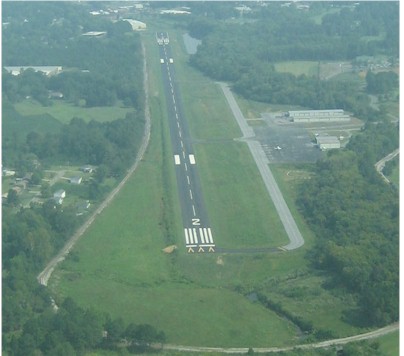
| Runway: 02 | Runway: 20 | ||
| Mag heading: | 23° | Mag heading: | 202° |
| Rwy Slope: | .09% Up | Rwy Slope: | -.09% Down |
| Approach: | Approach: | ||
| Pattern: | Left Traffic | Pattern: | Left Traffic |
| Markings: | NONPRECISION INSTRUMENT | Markings: | NONPRECISION INSTRUMENT |
| Marking Condition: | POOR; MARKINGS FADED BADLY | Marking Condition: | POOR; MARKINGS FADED BADLY |
| Arresting Dev: | Arresting Dev: | ||
| Lat & Long: | N3440.9 W08517.6 | Lat. & Long.: | N3441.7 W08517.2 |
| Elev: | 769.2 ft. MSL | Elev: | 774.1 ft. MSL |
| TCH: | 49 ft. AGL | TCH: | 54 ft. AGL |
| Visual Glide Path: | 3.75 degrees | Visual Glide Path: | 3.75 degrees |
| Displaced Threshold: | 65 feet | Displaced Threshold: | 449 feet |
| Touchdown Zone: | YES | Touchdown Zone: | YES |
| Touchdown Elev.: | 772.2 feet | Touchdown Elev.: | 776.3 feet |
| Visual Glide Slope: | 2-Light PAPI on RIGHT side of Runway | Visual Glide Slope: | 2-Light PAPI on RIGHT side of Runway |
| RVR Equipment: | RVR Equipment: | ||
| RVV Equipment: | NO | RVV Equipment: | NO |
| Approach Lights: | Approach Lights: | ||
| REIL: | NO | REIL: | NO |
| Centerline Lights: | NO | Centerline Lights: | NO |
| Touchdown lights: | NO | Touchdown lights: | NO |
| Runway Category: | Runway with a Non-precision Approach | Runway Category: | Runway with a Non-precision Approach |
| Declared Distances: | Declared Distances: | ||
| Obstructions: | TREES | Obstructions: | BLDG |
| Marked: | NOT Marked/Lighted | Marked: | NOT Marked/Lighted |
| Clearance slope: | 3:1 | Clearance slope: | 2:1; 0:1 AT DSPLCD THLD - RR TRACK -150 FT RIGHT. |
| Obstruction height: | 37 feet AGL | Obstruction height: | 32 feet AGL |
| Dist. from runway: | 311 feet | Dist. from runway: | 264 feet |
| Centerline offset: | 264 right of centerline | Centerline offset: | 157 feet right of centerline |
| Comments: | Comments: | 4 FT BERM 90 FT LEFT OF CENTERLINE FROM DISPLACED THRESHOLD TO 200' FROM EOR. |
Thanks for using FltPlan.com
all rights reserved © 1999-2021 by Flight Plan LLC