
| LAWRENCE COUNTY COURTLAND AL |
| |
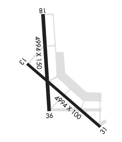
| Lat: N 3439.5 Long: W 08720.9 Elev: 588 Var: +03 Longest Runway: 4994 | ||
| AWOS: 118.52 CTAF: 122.7 | ||
| ||||||||||||||||||||||||||||||||||||||||||||
| ||||||||||||||||||||||||||||||||||||||||||||
| ||||||||||||||||||||||||||||||||||||||||||||
| ||||||||||||||||||||||||||||||||||||||||||||
| Rwy | Rwy | |||||||
| 4994x100 | 4994' | 4994x100 | 4994' | |||||
| 3484x150 | 3484' | 3484x150 | 3484' | |||||
| Runway ID | Single Wheel | Double Wheel | Double Tandem Wheel | Dual Double Wheel |
| 13/31 | N/A | N/A | N/A | N/A |
| 18/36 | N/A | N/A | N/A | N/A |
| These numbers are Advisory and are not limits. The Airport Manager should have more accurate Weight Limits | ||||
 Airport Diagram might not be current. | |
| Facility Name: | COURTLAND |
| City Name: | COURTLAND |
| County: | LAWRENCE |
| State abbrev: | AL |
| State Name: | ALABAMA |
| Ownership: | PUBLICLY OWNED |
| Use: | OPEN TO THE PUBLIC |
| Owner's Name: | LAWRENCE COUNTY COMMISSION |
| Address: | P. O. BOX 307 |
| MOULTON, AL 35650 | |
| Owner's Phone: | 256-974-0663 |
| Manager's Name: | LORETTA COTTINGHAM |
| Address: | 52 AIR FORCE STREET |
| COURTLAND, AL 35618 | |
| Phone: | 256-566-7846 |
| FAA Region: | SOUTHERN |
| FAA Field Office: | JAN |
| Date | Sunrise | Sunset |
|---|---|---|
| 09/24/21 Friday | 6:39 | 18:44 |
| 09/25/21 Saturday | 6:39 | 18:42 |
| 09/26/21 Sunday | 6:40 | 18:41 |
| 09/27/21 Monday | 6:41 | 18:39 |
| 09/28/21 Tuesday | 6:42 | 18:38 |
| 09/29/21 Wednesday | 6:42 | 18:37 |
| 09/30/21 Thursday | 6:43 | 18:35 |
| 10/01/21 Friday | 6:44 | 18:34 |
| 10/02/21 Saturday | 6:45 | 18:32 |
| 10/03/21 Sunday | 6:45 | 18:31 |
| 10/04/21 Monday | 6:46 | 18:30 |
| 10/05/21 Tuesday | 6:47 | 18:28 |
| 10/06/21 Wednesday | 6:48 | 18:27 |
| 10/07/21 Thursday | 6:48 | 18:26 |
| Airport Attendance Schedule | UNATTENDED |
| Airport Status | OPERATIONAL (This Status can change at any time - please check NOTAMS) |
| Airport Lighting Schedule | HIRL RWY 13/31 PRESET LOW INTST, TO INCR INTST AND ACTVT REILS RWY 13 & 31 - CTAF. NO TWY LGTS. |
| Airport Storage Available | Tie Downs |
| Extra Services Available | NONE |
| Wind Indicator | YES - (lighted) |
| Control Tower | NO |
| CTAF Frequency | 122.700 |
| Unicom Frequency | 122.700 |
| Rotating Beacon Color | CLEAR-GREEN (Light Land Airport) |
| Segmented Circle | NO |
| Landing Fee |
| Airport Inspected | STATE - performed by STATE AERONAUTICAL PERSONNEL |
| Inspection Date | 07/15/2020 |
| Type of Fuel Available | Grade 100LL; -10100LL FUEL AVBL 24/7 WITH CC. |
| Airframe Repair Service | NONE |
| Power Plant Repair Service | NONE |
| Latitude | N3439.5 |
| Longitude | W08720.9 (ESTIMATED) |
| Arpt Elevation | 588ft (ESTIMATED) |
| Magnetic Variation | 03W |
| 2 miles NE | of COURTLAND |
| Traffic Pattern Altitude | |
| Sectional Chart | ATLANTA |
| Operations (Reported) | Yearly | Avg. Daily |
|---|---|---|
| General Aviation Transient | 9900 | 27 |
| General Aviation Local | 1000 | 3 |
| Air Taxi | 0 | 0 |
| Commerical | 0 | 0 |
| Commuter | 0 | 0 |
| Military | 1000 | 3 |
| Aircraft based on Field | |
|---|---|
| General Aviation Singles | 13 |
| General Aviation Multi | 2 |
| Jet Aircraft | 0 |
| General Aviation Helicopters | 2 |
| Military Aircraft | 0 |
| Gliders | 1 |
| Ultralights | 1 |
| FSS on field | NO |
| FSS tie-in | ANNISTON |
| FSS Phone | 1-800-WX-BRIEF |
| Who issues Notams | ANB |
| Notam D service at airport | YES |
| ARTCC Name | MEMPHIS |
| Airport Certification | |
| Aircraft Rescue & Firefighting Index | None |
| Airport of Entry | No |
| Custom Landing Rights | No |
| Joint Civil/Military | No |
| Military Landing rights | No |
| NATIONAL PLAN OF INTEGRATED AIRPORT SYSTEMS (NPIAS) |
| GRANT AGREEMENTS UNDER FAAP/ADAP/AIP |
| ASSURANCES PURSUANT TO TITLE VI, CIVIL RIGHTS ACT OF 1964 |
| FOR CD CTC HUNTSVILLE APCH AT 256-542-2070, WHEN APCH CLSD CTC MEMPHIS ARTCC AT 901-368-8453/8449. |
| PORTIONS OF RAMP ARE IN POOR COND WITH LOOSE CHUNKS OF CONC AND VEG GROWTH. |
| RWY 18/3 6 SVRL CONC BLX/JOINTS ARE UNEVEN 200 FT FM PAVEMENT END OF RWY 36. POTHOLES AND LOOSE CHUNKS OF CONC PRESENT ON RWY 18/36. |
Airport Communications & Frequencies:
| |||||||||||||||||
| Runway: 13 | Runway: 31 | ||
| Mag heading: | 133° | Mag heading: | 313° |
| Rwy Slope: | -.20% Down | Rwy Slope: | .20% Up |
| Approach: | Approach: | ||
| Pattern: | Left Traffic | Pattern: | Left Traffic |
| Markings: | NONPRECISION INSTRUMENT | Markings: | NONPRECISION INSTRUMENT |
| Marking Condition: | GOOD | Marking Condition: | GOOD |
| Arresting Dev: | Arresting Dev: | ||
| Lat & Long: | N3439.7 W08721.2 | Lat. & Long.: | N3439.2 W08720.5 |
| Elev: | 581.5 ft. MSL | Elev: | 571.7 ft. MSL |
| TCH: | TCH: | ||
| Visual Glide Path: | Visual Glide Path: | ||
| Displaced Threshold: | No | Displaced Threshold: | No |
| Touchdown Zone: | YES | Touchdown Zone: | YES |
| Touchdown Elev.: | 582.4 feet | Touchdown Elev.: | 578.7 feet |
| Visual Glide Slope: | Visual Glide Slope: | ||
| RVR Equipment: | RVR Equipment: | ||
| RVV Equipment: | NO | RVV Equipment: | NO |
| Approach Lights: | Approach Lights: | ||
| REIL: | YES | REIL: | YES |
| Centerline Lights: | NO | Centerline Lights: | NO |
| Touchdown lights: | NO | Touchdown lights: | NO |
| Runway Category: | Runway with a Non-precision Approach having visibility minimums greater than 3/4 mile | Runway Category: | Runway with a Non-precision Approach having visibility minimums greater than 3/4 mile |
| Declared Distances: | Declared Distances: |
| Runway: 18 | Runway: 36 | ||
| Mag heading: | 178° | Mag heading: | 358° |
| Rwy Slope: | -.22% Down | Rwy Slope: | .22% Up |
| Approach: | Approach: | ||
| Pattern: | Left Traffic | Pattern: | Left Traffic |
| Markings: | BASIC | Markings: | BASIC |
| Marking Condition: | GOOD | Marking Condition: | FAIR |
| Arresting Dev: | Arresting Dev: | ||
| Lat & Long: | N3439.9 W08721.0 | Lat. & Long.: | N3439.3 W08721.0 |
| Elev: | 588.0 ft. MSL | Elev: | 580.2 ft. MSL |
| TCH: | TCH: | ||
| Visual Glide Path: | Visual Glide Path: | ||
| Displaced Threshold: | No | Displaced Threshold: | No |
| Touchdown Zone: | YES | Touchdown Zone: | YES |
| Touchdown Elev.: | 588.0 feet | Touchdown Elev.: | 586.8 feet |
| Visual Glide Slope: | Visual Glide Slope: | ||
| RVR Equipment: | RVR Equipment: | ||
| RVV Equipment: | NO | RVV Equipment: | NO |
| Approach Lights: | Approach Lights: | ||
| REIL: | NO | REIL: | NO |
| Centerline Lights: | NO | Centerline Lights: | NO |
| Touchdown lights: | NO | Touchdown lights: | NO |
| Runway Category: | Runway with a Visual Approach | Runway Category: | Runway with a Visual Approach |
| Declared Distances: | Declared Distances: | ||
| Obstructions: | TREE | Obstructions: | |
| Marked: | NOT Marked/Lighted | Marked: | |
| Clearance slope: | 10:1 | Clearance slope: | 50:1 |
| Obstruction height: | 54 feet AGL | Obstruction height: | |
| Dist. from runway: | 747 feet | Dist. from runway: | |
| Centerline offset: | 298 left of centerline | Centerline offset: | |
| Comments: | Comments: |
Thanks for using FltPlan.com
all rights reserved © 1999-2021 by Flight Plan LLC
