
| BEULAH BEULAH ND |
| |
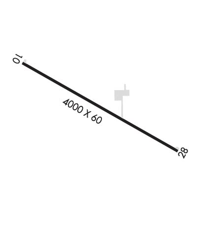
| Lat: N 4715.1 Long: W 10148.9 Elev: 1791 Var: -11 Longest Runway: 4030 | ||
| CTAF: 122.9 | ||
| ||||||
|
| Rwy | Rwy | |||||||
| 4030x60 | 4030' | 4030x60 | 4030' | |||||
| Runway ID | Single Wheel | Double Wheel | Double Tandem Wheel | Dual Double Wheel |
| 10/28 | 12,500 | N/A | N/A | N/A |
| These numbers are Advisory and are not limits. The Airport Manager should have more accurate Weight Limits | ||||
| FltPlan does not have IFR approach charts available for K95D. |
 Airport Diagram might not be current. | |
| Facility Name: | BEULAH |
| City Name: | BEULAH |
| County: | MERCER |
| State abbrev: | ND |
| State Name: | NORTH DAKOTA |
| Ownership: | PUBLICLY OWNED |
| Use: | OPEN TO THE PUBLIC |
| Owner's Name: | BEULAH MUNICIPAL AIRPORT AUTHORITY |
| Address: | 218 10TH ST NW; CHAIR OF APT AUTH - BO KLINDWORTH |
| BEULAH, ND 58523 | |
| Owner's Phone: | (701) 873-6712 |
| Manager's Name: | SHAWN MORTEN; OR CTC KEVIN LEE, ARPT AUTH (701) 873-2259 OR (701) 873-2311. |
| Address: | 6220 COUNTY ROAD 20 |
| BEULAH, ND 58523 | |
| Phone: | 701-873-4100 |
| FAA Region: | GREAT LAKES |
| FAA Field Office: | DMA |
| Date | Sunrise | Sunset |
|---|---|---|
| 09/24/21 Friday | 7:36 | 19:41 |
| 09/25/21 Saturday | 7:38 | 19:39 |
| 09/26/21 Sunday | 7:39 | 19:37 |
| 09/27/21 Monday | 7:40 | 19:35 |
| 09/28/21 Tuesday | 7:42 | 19:33 |
| 09/29/21 Wednesday | 7:43 | 19:31 |
| 09/30/21 Thursday | 7:45 | 19:29 |
| 10/01/21 Friday | 7:46 | 19:27 |
| 10/02/21 Saturday | 7:47 | 19:25 |
| 10/03/21 Sunday | 7:49 | 19:23 |
| 10/04/21 Monday | 7:50 | 19:21 |
| 10/05/21 Tuesday | 7:51 | 19:19 |
| 10/06/21 Wednesday | 7:53 | 19:17 |
| 10/07/21 Thursday | 7:54 | 19:15 |
| Airport Attendance Schedule | UNATTENDED; AMGR ON CALL CONTINUOUSLY (710) 873-4100. |
| Airport Status | OPERATIONAL (This Status can change at any time - please check NOTAMS) |
| Airport Lighting Schedule | ACTVT LIRL RY 10/28 & SAVASI RY 28 - CTAF.; ACTVT ROTG BCN - CTAF. |
| Airport Storage Available | Tie Downs, Hanger |
| Extra Services Available | Crop Dusting, Flight Instruction, Aircraft Rental, Annual Surveying |
| Wind Indicator | YES - (lighted) |
| Control Tower | NO |
| CTAF Frequency | 122.900 |
| Unicom Frequency | |
| Rotating Beacon Color | CLEAR-GREEN (Light Land Airport) |
| Segmented Circle | NO |
| Landing Fee | NO |
| Airport Inspected | STATE - performed by STATE AERONAUTICAL PERSONNEL |
| Inspection Date | 05/01/2020 |
| Type of Fuel Available | Grade 100LL, JET A-1 (freeze point -50C); -10FOR FUEL CALL 701-873-4100/2259/2311. |
| Airframe Repair Service | MAJOR |
| Power Plant Repair Service | MAJOR |
| Latitude | N4715.1 |
| Longitude | W10148.9 (ESTIMATED) |
| Arpt Elevation | 1791ft (SURVEYED) |
| Magnetic Variation | 11E |
| 2 miles SW | of BEULAH |
| Traffic Pattern Altitude | |
| Sectional Chart | BILLINGS |
| Operations (Reported) | Yearly | Avg. Daily |
|---|---|---|
| General Aviation Transient | 800 | 2 |
| General Aviation Local | 800 | 2 |
| Air Taxi | 200 | 1 |
| Commerical | 0 | 0 |
| Commuter | 0 | 0 |
| Military | 30 | 0 |
| Aircraft based on Field | |
|---|---|
| General Aviation Singles | 16 |
| General Aviation Multi | 1 |
| Jet Aircraft | 0 |
| General Aviation Helicopters | 3 |
| Military Aircraft | 0 |
| Gliders | 0 |
| Ultralights | 0 |
| FSS on field | NO |
| FSS tie-in | GRAND FORKS |
| FSS Phone | 1-800-WX-BRIEF |
| Who issues Notams | GFK |
| Notam D service at airport | YES |
| ARTCC Name | MINNEAPOLIS |
| Airport Certification | |
| Aircraft Rescue & Firefighting Index | None |
| Airport of Entry | No |
| Custom Landing Rights | No |
| Joint Civil/Military | No |
| Military Landing rights | No |
| LIGHTED STACK 498' AGL LCTD 1.8 NM S. |
| ARPT LCTD IN RIVER VALLEY WITH +200' RDGS SRNDG APRX 1500' FM THR. |
| 250 FT AGL STACK WITH INVISIBLE FLAME TO 250 FT ABV STACK LCTD 8 NM NNW. |
| SNOW REMOVAL IREG; CONFIRM WINTER CONDITIONS WITH AMGR (701) 873-4100 OR (701) 870-4100. |
| STACKS 600 FT AGL 6 MI N UNLGTD. |
| BIRDS & DEER ON & INVOF ARPT. |
| FOR CD CTC MINNEAPOLIS ARTCC AT 651-463-5588. |
| RWY 10/2 8 NSTD LIRL 20 FT FROM EDGE OF ASPH SFC. |
| Runway: 10 | Runway: 28 | ||
| Mag heading: | 104° | Mag heading: | 284° |
| Rwy Slope: | -.17% Down | Rwy Slope: | .17% Up |
| Approach: | Approach: | ||
| Pattern: | Left Traffic | Pattern: | Left Traffic |
| Markings: | BASIC | Markings: | BASIC |
| Marking Condition: | GOOD | Marking Condition: | GOOD |
| Arresting Dev: | Arresting Dev: | ||
| Lat & Long: | N4715.2 W10149.3 | Lat. & Long.: | N4714.9 W10148.5 |
| Elev: | 1791.0 ft. MSL | Elev: | 1784.0 ft. MSL |
| TCH: | TCH: | 25 ft. AGL | |
| Visual Glide Path: | Visual Glide Path: | 3.00 degrees | |
| Displaced Threshold: | No | Displaced Threshold: | No |
| Touchdown Zone: | NO | Touchdown Zone: | NO |
| Touchdown Elev.: | Touchdown Elev.: | ||
| Visual Glide Slope: | Visual Glide Slope: | 2-BOX SIMPLIFIED ABBREVIATED VISUAL APPROACH SLOPE INDICATOR ON LEFT SIDE OF RUNWAY | |
| RVR Equipment: | RVR Equipment: | ||
| RVV Equipment: | NO | RVV Equipment: | NO |
| Approach Lights: | Approach Lights: | ||
| REIL: | NO | REIL: | NO |
| Centerline Lights: | NO | Centerline Lights: | NO |
| Touchdown lights: | NO | Touchdown lights: | NO |
| Runway Category: | Runway with a Visual Approach | Runway Category: | Runway with a Visual Approach |
| Declared Distances: | Declared Distances: | ||
| Obstructions: | TREE; +50 FT TREE 1800 FT FM THLD; 75 FT L OF EXTDD CNTRLN; APCH RATIO 34:1. | Obstructions: | ROAD; ALSO +1 FT FENCE 225 FT FROM CNTRLN; APCH RATIO 25:1. |
| Marked: | NOT Marked/Lighted | Marked: | NOT Marked/Lighted |
| Clearance slope: | 12:1 | Clearance slope: | 2:1 |
| Obstruction height: | 10 feet AGL | Obstruction height: | 10 feet AGL |
| Dist. from runway: | 325 feet | Dist. from runway: | 225 feet |
| Centerline offset: | 130 left of centerline | Centerline offset: | 125 feet right of centerline |
| Comments: | 4 FT FENCE 115 FT FM THLD 60 FT L OF CNTRLN. | Comments: | +4 FT FENCE 100 FT FM THLD 50 FT LEFT OF CNTRLN. |
Thanks for using FltPlan.com
all rights reserved © 1999-2021 by Flight Plan LLC
