
| SAUK-PRAIRIE PRAIRIE DU SAC WI |
| |
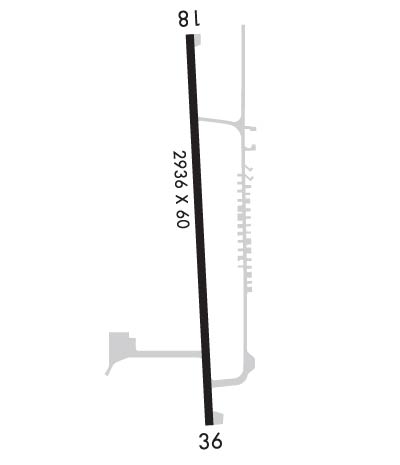
| Lat: N 4317.9 Long: W 08945.3 Elev: 832 Var: -00 Longest Runway: 2936 | ||
| CTAF: 122.9 | ||
| ||||||||||||||||||||||||||||||||
| ||||||||||||||||||||||||||||||||
| Rwy | Rwy | |||||||
| 2936x60 | 2936' | 2936x60 | 2936' | |||||
| Runway ID | Single Wheel | Double Wheel | Double Tandem Wheel | Dual Double Wheel |
| 18/36 | N/A | N/A | N/A | N/A |
| These numbers are Advisory and are not limits. The Airport Manager should have more accurate Weight Limits | ||||
 Airport Diagram might not be current. | |
| Facility Name: | SAUK-PRAIRIE |
| City Name: | PRAIRIE DU SAC |
| County: | SAUK |
| State abbrev: | WI |
| State Name: | WISCONSIN |
| Ownership: | PRIVATELY OWNED |
| Use: | OPEN TO THE PUBLIC |
| Owner's Name: | CFM INVESTMENTS |
| Address: | ONE QUENCH DRIVE |
| PRAIRIE DU SAC, WI 53578 | |
| Owner's Phone: | 608-643-8530 |
| Manager's Name: | SAUK PRAIRIE AIRPORT INC. |
| Address: | P O BOX 7 |
| PRAIRIE DU SAC, WI 53754 | |
| Phone: | 608-577-3754 |
| FAA Region: | GREAT LAKES |
| FAA Field Office: | CHI |
| Date | Sunrise | Sunset |
|---|---|---|
| 09/24/21 Friday | 6:48 | 18:53 |
| 09/25/21 Saturday | 6:49 | 18:51 |
| 09/26/21 Sunday | 6:50 | 18:50 |
| 09/27/21 Monday | 6:52 | 18:48 |
| 09/28/21 Tuesday | 6:53 | 18:46 |
| 09/29/21 Wednesday | 6:54 | 18:44 |
| 09/30/21 Thursday | 6:55 | 18:42 |
| 10/01/21 Friday | 6:56 | 18:41 |
| 10/02/21 Saturday | 6:57 | 18:39 |
| 10/03/21 Sunday | 6:58 | 18:37 |
| 10/04/21 Monday | 7:00 | 18:35 |
| 10/05/21 Tuesday | 7:01 | 18:33 |
| 10/06/21 Wednesday | 7:02 | 18:32 |
| 10/07/21 Thursday | 7:03 | 18:30 |
| Airport Attendance Schedule | |
| Airport Status | OPERATIONAL (This Status can change at any time - please check NOTAMS) |
| Airport Lighting Schedule | ACTVT MIRL RY 18/36, REIL RYS 18 & 36, & PAPI RYS 18 & 36 - CTAF. |
| Airport Storage Available | Tie Downs |
| Extra Services Available | NONE |
| Wind Indicator | YES - (lighted) |
| Control Tower | NO |
| CTAF Frequency | 122.900 |
| Unicom Frequency | |
| Rotating Beacon Color | CLEAR-GREEN (Light Land Airport) |
| Segmented Circle | NO |
| Landing Fee | NO |
| Airport Inspected | STATE - performed by STATE AERONAUTICAL PERSONNEL |
| Inspection Date | 07/16/2020 |
| Type of Fuel Available | L94 |
| Airframe Repair Service | MAJOR |
| Power Plant Repair Service | MAJOR |
| Latitude | N4317.9 |
| Longitude | W08945.3 (ESTIMATED) |
| Arpt Elevation | 832ft (SURVEYED) |
| Magnetic Variation | 00E |
| 2 miles W | of PRAIRIE DU SAC |
| Traffic Pattern Altitude | |
| Sectional Chart | CHICAGO |
| Operations (Reported) | Yearly | Avg. Daily |
|---|---|---|
| General Aviation Transient | 2500 | 7 |
| General Aviation Local | 5500 | 15 |
| Air Taxi | 50 | 0 |
| Commerical | 0 | 0 |
| Commuter | 0 | 0 |
| Military | 300 | 1 |
| Aircraft based on Field | |
|---|---|
| General Aviation Singles | 27 |
| General Aviation Multi | 0 |
| Jet Aircraft | 1 |
| General Aviation Helicopters | 0 |
| Military Aircraft | 0 |
| Gliders | 1 |
| Ultralights | 0 |
| FSS on field | NO |
| FSS tie-in | GREEN BAY |
| FSS Phone | 1-800-WX-BRIEF |
| Who issues Notams | GRB |
| Notam D service at airport | YES |
| ARTCC Name | CHICAGO |
| Airport Certification | |
| Aircraft Rescue & Firefighting Index | None |
| Airport of Entry | No |
| Custom Landing Rights | No |
| Joint Civil/Military | No |
| Military Landing rights | No |
| NATIONAL PLAN OF INTEGRATED AIRPORT SYSTEMS (NPIAS) |
| ULTRALIGHT ACTVTY ON & INVOF ARPT. |
| MAINT VEHICLE TFC ON AND INVOF ARPT. |
| W RAMP AND TWY PVT, CLSD TSNT. |
| AVOID HOSPITAL/HELIPAD 3,000 FT SOUTHEAST OF RY 36 THLD. |
| RY 18 DEPS CLIMB TO 1,800 FT MSL ON RY HEADING BFR TURNING EAST/SOUTHEAST. |
| TKOFS & LDGS ARE PROHIBITED ON UNPAVED SFCS. |
| FOR CD CTC CHICAGO ARTCC AT 630-906-8921. |
Airport Communications & Frequencies:
| |||||||||||||||
| Runway: 18 | Runway: 36 | ||
| Mag heading: | 177° | Mag heading: | 357° |
| Rwy Slope: | -.38% Down | Rwy Slope: | .38% Up |
| Approach: | Approach: | ||
| Pattern: | Left Traffic | Pattern: | Left Traffic |
| Markings: | NONPRECISION INSTRUMENT | Markings: | NONPRECISION INSTRUMENT |
| Marking Condition: | GOOD | Marking Condition: | GOOD |
| Arresting Dev: | Arresting Dev: | ||
| Lat & Long: | N4318.1 W08945.4 | Lat. & Long.: | N4317.6 W08945.3 |
| Elev: | 831.4 ft. MSL | Elev: | 820.1 ft. MSL |
| TCH: | 26 ft. AGL | TCH: | 26 ft. AGL |
| Visual Glide Path: | 3.00 degrees | Visual Glide Path: | 3.00 degrees |
| Displaced Threshold: | No | Displaced Threshold: | No |
| Touchdown Zone: | YES | Touchdown Zone: | YES |
| Touchdown Elev.: | 832.0 feet | Touchdown Elev.: | 832.0 feet |
| Visual Glide Slope: | 2-Light PAPI on LEFT side of Runway | Visual Glide Slope: | 2-Light PAPI on LEFT side of Runway |
| RVR Equipment: | RVR Equipment: | ||
| RVV Equipment: | NO | RVV Equipment: | NO |
| Approach Lights: | Approach Lights: | ||
| REIL: | YES | REIL: | YES |
| Centerline Lights: | NO | Centerline Lights: | NO |
| Touchdown lights: | NO | Touchdown lights: | NO |
| Runway Category: | Runway with a Non-precision Approach | Runway Category: | Runway with a Non-precision Approach |
| Declared Distances: | Declared Distances: |
Thanks for using FltPlan.com
all rights reserved © 1999-2021 by Flight Plan LLC
