
| WASHINGTON COUNTY POTOSI MO |
| |
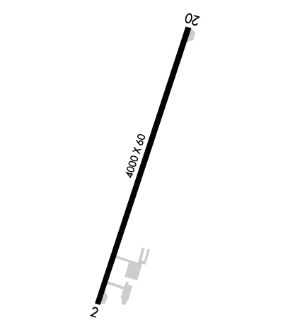
| Lat: N 3755.8 Long: W 09043.9 Elev: 959 Var: -00 Longest Runway: 4000 | ||
| CTAF: 123.0 | ||
| ||||||
|
| Rwy | Rwy | |||||||
| 4000x60 | 4000' | 4000x60 | 4000' | |||||
| Runway ID | Single Wheel | Double Wheel | Double Tandem Wheel | Dual Double Wheel |
| 02/20 | 11,000 | N/A | N/A | N/A |
| These numbers are Advisory and are not limits. The Airport Manager should have more accurate Weight Limits | ||||
 Airport Diagram might not be current. | |
| Facility Name: | WASHINGTON COUNTY |
| City Name: | POTOSI |
| County: | WASHINGTON |
| State abbrev: | MO |
| State Name: | MISSOURI |
| Ownership: | PUBLICLY OWNED |
| Use: | OPEN TO THE PUBLIC |
| Owner's Name: | WASHINGTON COUNTY; SAM RHODES, AIRPORT BOARD PRESIDENT. |
| Address: | BOX 398, 102 NORTH MISSOURI STREET |
| POTOSI, MO 63664 | |
| Owner's Phone: | 573-438-4901 |
| Manager's Name: | DANNY WILSON |
| Address: | 12225 EAST STATE HIGHWAY 8 |
| MINERAL POINT, MO 63660 | |
| Phone: | 573-854-9173 |
| FAA Region: | CENTRAL |
| FAA Field Office: | NONE |
| Date | Sunrise | Sunset |
|---|---|---|
| 09/24/21 Friday | 6:52 | 18:57 |
| 09/25/21 Saturday | 6:53 | 18:56 |
| 09/26/21 Sunday | 6:54 | 18:54 |
| 09/27/21 Monday | 6:55 | 18:52 |
| 09/28/21 Tuesday | 6:56 | 18:51 |
| 09/29/21 Wednesday | 6:57 | 18:49 |
| 09/30/21 Thursday | 6:57 | 18:48 |
| 10/01/21 Friday | 6:58 | 18:46 |
| 10/02/21 Saturday | 6:59 | 18:45 |
| 10/03/21 Sunday | 7:00 | 18:43 |
| 10/04/21 Monday | 7:01 | 18:42 |
| 10/05/21 Tuesday | 7:02 | 18:40 |
| 10/06/21 Wednesday | 7:03 | 18:39 |
| 10/07/21 Thursday | 7:04 | 18:37 |
| Airport Attendance Schedule | MON-FRI 0800-1630 |
| Airport Status | OPERATIONAL (This Status can change at any time - please check NOTAMS) |
| Airport Lighting Schedule | ACTVT MIRL RY 02/20 - CTAF. |
| Airport Storage Available | Tie Downs, Hanger |
| Extra Services Available | NONE |
| Wind Indicator | YES - (lighted) |
| Control Tower | NO |
| CTAF Frequency | 123.000 |
| Unicom Frequency | 123.000 |
| Rotating Beacon Color | CLEAR-GREEN (Light Land Airport) |
| Segmented Circle | YES |
| Landing Fee | NO |
| Airport Inspected | STATE - performed by STATE AERONAUTICAL PERSONNEL |
| Inspection Date | 07/02/2020 |
| Type of Fuel Available | Grade 100LL, JET A (freeze point -40C) |
| Airframe Repair Service | None |
| Power Plant Repair Service | None |
| Latitude | N3755.8 |
| Longitude | W09043.9 (ESTIMATED) |
| Arpt Elevation | 959ft (SURVEYED) |
| Magnetic Variation | 00E |
| 3 miles E | of POTOSI |
| Traffic Pattern Altitude | |
| Sectional Chart | ST LOUIS |
| Operations (Reported) | Yearly | Avg. Daily |
|---|---|---|
| General Aviation Transient | 870 | 2 |
| General Aviation Local | 2750 | 8 |
| Air Taxi | 40 | 0 |
| Commerical | 0 | 0 |
| Commuter | 0 | 0 |
| Military | 40 | 0 |
| Aircraft based on Field | |
|---|---|
| General Aviation Singles | 12 |
| General Aviation Multi | 1 |
| Jet Aircraft | 0 |
| General Aviation Helicopters | 0 |
| Military Aircraft | 0 |
| Gliders | 0 |
| Ultralights | 0 |
| FSS on field | NO |
| FSS tie-in | SAINT LOUIS |
| FSS Phone | 1-800-WX-BRIEF |
| Who issues Notams | STL |
| Notam D service at airport | YES |
| ARTCC Name | KANSAS CITY |
| Airport Certification | |
| Aircraft Rescue & Firefighting Index | None |
| Airport of Entry | No |
| Custom Landing Rights | No |
| Joint Civil/Military | No |
| Military Landing rights | YES |
| NATIONAL PLAN OF INTEGRATED AIRPORT SYSTEMS (NPIAS) |
| ASSURANCES PURSUANT TO TITLE VI, CIVIL RIGHTS ACT OF 1964 |
| GRANT AGREEMENT HAS EXPIRED; HOWEVER, AGREEMENT REMAINS IN EFFECT FOR THIS FACILITY AS LONG AS IT IS PUBLIC USE. |
| WILDLIFE ON & INVOF ARPT. |
| USE RIGHT TFC FOR RY 02; DO NOT OVERFLY PRISON AREA. |
| 24-HR SS 100LL AND JET-A FUEL LOCATED AT SOUTH APRON. |
| FOR CD CTC KANSAS CITY ARTCC AT 913-254-8508. |
| RWY 02/2 0 PAVEMENT RATED FOR ACFT UNDER 12,500 LBS. |
Airport Communications & Frequencies:
| |||||||||
| Runway: 02 | Runway: 20 | ||
| Mag heading: | 19° | Mag heading: | 199° |
| Rwy Slope: | -.33% Down | Rwy Slope: | .33% Up |
| Approach: | Approach: | ||
| Pattern: | Right Traffic | Pattern: | Left Traffic |
| Markings: | NONPRECISION INSTRUMENT | Markings: | NONPRECISION INSTRUMENT |
| Marking Condition: | GOOD | Marking Condition: | GOOD |
| Arresting Dev: | Arresting Dev: | ||
| Lat & Long: | N3755.4 W09044.0 | Lat. & Long.: | N3756.1 W09043.8 |
| Elev: | 959.2 ft. MSL | Elev: | 946.1 ft. MSL |
| TCH: | TCH: | ||
| Visual Glide Path: | Visual Glide Path: | ||
| Displaced Threshold: | No | Displaced Threshold: | No |
| Touchdown Zone: | YES | Touchdown Zone: | YES |
| Touchdown Elev.: | 959.3 feet | Touchdown Elev.: | 957.9 feet |
| Visual Glide Slope: | Visual Glide Slope: | ||
| RVR Equipment: | RVR Equipment: | ||
| RVV Equipment: | NO | RVV Equipment: | NO |
| Approach Lights: | Approach Lights: | ||
| REIL: | NO | REIL: | NO |
| Centerline Lights: | NO | Centerline Lights: | NO |
| Touchdown lights: | NO | Touchdown lights: | NO |
| Runway Category: | Runway with a Non-precision Approach | Runway Category: | Runway with a Non-precision Approach |
| Declared Distances: | Declared Distances: | ||
| Obstructions: | TREE | Obstructions: | |
| Marked: | NOT Marked/Lighted | Marked: | |
| Clearance slope: | 8:1 | Clearance slope: | 20:1 |
| Obstruction height: | 64 feet AGL | Obstruction height: | |
| Dist. from runway: | 735 feet | Dist. from runway: | |
| Centerline offset: | 300 left of centerline | Centerline offset: | |
| Comments: | Comments: | 6-15 FT BRUSH AND SMALL TREES, 107 FT LEFT OF CL; 118-228 FT RIGHT OF CL, 0-120 FT FROM RWY END |
Thanks for using FltPlan.com
all rights reserved © 1999-2021 by Flight Plan LLC
