
| NEW MARKET NEW MARKET VA |
| |
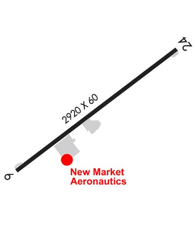
| Lat: N 3839.4 Long: W 07842.5 Elev: 963 Var: +10 Longest Runway: 2920 | ||
| AWOS: 118.17 CTAF: 122.8 | ||
| ||||||||||||||||||||||||||||||||||||||||||||
| ||||||||||||||||||||||||||||||||||||||||||||
| ||||||||||||||||||||||||||||||||||||||||||||
| Rwy | Rwy | |||||||
| 2920x60 | 2920' | 2920x60 | 2002' | |||||
| Runway ID | Single Wheel | Double Wheel | Double Tandem Wheel | Dual Double Wheel |
| 06/24 | N/A | N/A | N/A | N/A |
| These numbers are Advisory and are not limits. The Airport Manager should have more accurate Weight Limits | ||||
 Airport Diagram might not be current. | |
| Facility Name: | NEW MARKET |
| City Name: | NEW MARKET |
| County: | SHENANDOAH |
| State abbrev: | VA |
| State Name: | VIRGINIA |
| Ownership: | PRIVATELY OWNED |
| Use: | OPEN TO THE PUBLIC |
| Owner's Name: | ROBERT THOMAS |
| Address: | PO BOX 762 |
| MIDDLEBURG, VA 20118 | |
| Owner's Phone: | (703) 898-1157 |
| Manager's Name: | ROBERT THOMAS |
| Address: | PO BOX 762 |
| MIDDLEBURG, VA 20118 | |
| Phone: | 703-327-0444 |
| FAA Region: | EASTERN |
| FAA Field Office: | DCA |
| Date | Sunrise | Sunset |
|---|---|---|
| 06/08/26 Monday | 5:50 | 20:38 |
| 06/09/26 Tuesday | 5:50 | 20:38 |
| 06/10/26 Wednesday | 5:50 | 20:39 |
| 06/11/26 Thursday | 5:50 | 20:39 |
| 06/12/26 Friday | 5:50 | 20:40 |
| 06/13/26 Saturday | 5:50 | 20:40 |
| 06/14/26 Sunday | 5:50 | 20:41 |
| 06/15/26 Monday | 5:50 | 20:41 |
| 06/16/26 Tuesday | 5:50 | 20:41 |
| 06/17/26 Wednesday | 5:50 | 20:42 |
| 06/18/26 Thursday | 5:50 | 20:42 |
| 06/19/26 Friday | 5:50 | 20:42 |
| 06/20/26 Saturday | 5:50 | 20:43 |
| 06/21/26 Sunday | 5:50 | 20:43 |
| Airport Attendance Schedule | M-F 0800 - 1630; UNATNDD THANKSGIVING, CHRISTMAS, AND NEW YEAR'S DAY. |
| Airport Status | OPERATIONAL (This Status can change at any time - please check NOTAMS) |
| Airport Lighting Schedule | SS-SR |
| Airport Storage Available | Tie Downs, Hanger |
| Extra Services Available | Flight Instruction, Parachute Jumping |
| Wind Indicator | YES - (lighted) |
| Control Tower | NO |
| CTAF Frequency | 122.800 |
| Unicom Frequency | 122.800 |
| Rotating Beacon Color | WG |
| Segmented Circle | NO |
| Landing Fee |
| Airport Inspected | STATE - performed by STATE AERONAUTICAL PERSONNEL |
| Inspection Date | 06/11/2024 |
| Type of Fuel Available | Grade 100LL; -1024 HR CREDIT CARD SVC |
| Airframe Repair Service | MAJOR; BLN RPR STN; ACFT RPRS AVBL, BUT NOT FULL-TIME. |
| Power Plant Repair Service | MAJOR; PWR PLANT RPRS AVBL, BUT NOT FULL-TIME. |
| Latitude | N3839.4 |
| Longitude | W07842.5 (ESTIMATED) |
| Arpt Elevation | 962ft (ESTIMATED) |
| Magnetic Variation | 10W |
| 2 miles W | of NEW MARKET |
| Traffic Pattern Altitude | 825 |
| Sectional Chart | WASHINGTON |
| Operations (Reported) | Yearly | Avg. Daily |
|---|---|---|
| General Aviation Transient | 0 | 0 |
| General Aviation Local | 0 | 0 |
| Air Taxi | 0 | 0 |
| Commerical | 0 | 0 |
| Commuter | 0 | 0 |
| Military | 0 | 0 |
| Aircraft based on Field | |
|---|---|
| General Aviation Singles | 0 |
| General Aviation Multi | 0 |
| Jet Aircraft | 0 |
| General Aviation Helicopters | 0 |
| Military Aircraft | 0 |
| Gliders | 0 |
| Ultralights | 0 |
| FSS on field | NO |
| FSS tie-in | LEESBURG |
| FSS Phone | 1-800-WX-BRIEF |
| Who issues Notams | DCA |
| Notam D service at airport | YES |
| ARTCC Name | WASHINGTON |
| Airport Certification | |
| Aircraft Rescue & Firefighting Index | None |
| Airport of Entry | No |
| Custom Landing Rights | No |
| Joint Civil/Military | No |
| Military Landing rights | No |
| DEER AND BIRDS ON & INVOF RY. |
| FOR CD CTC WASHINGTON ARTCC AT 703-771-3587. |
| HOT AIR BALLOONS WEEKENDS EARLY MORNING & LATE AFTERNOON. |
| APRXLY 1000 FT N OF RY, 200 FT RIDGE/TREES PARALLEL RY. |
| ARRIVING PILOTS SHOULD USE CAUTION. SKYDIVING OPERATIONS WITHIN 2NM OF THE AIRPORT FROM 0800-SUNSET EVERY WEEKEND AND OCCASIONALLY DURING THE WEEK. |
| RWY 06/2 4 NSTD LIRL; THLD LGTS ONE FIXTURE EACH SIDE. RY 06 LGTD THLD RELOCATED 100 FT & RY 24 LGTD THLD RELOCATED 930 FT FOR NGT OPNS; 2020 FT RY 06/24 LGTD AT NGT. NO RY END LGTS RY 24. |
Airport Communications & Frequencies:
| |||||||||
| Runway: 06 | Runway: 24 | ||
| Mag heading: | 63° | Mag heading: | 243° |
| Rwy Slope: | .00% Up | Rwy Slope: | .00% Down |
| Approach: | Approach: | ||
| Pattern: | Right Traffic | Pattern: | Left Traffic |
| Markings: | BASIC | Markings: | BASIC |
| Marking Condition: | GOOD | Marking Condition: | GOOD |
| Arresting Dev: | Arresting Dev: | ||
| Lat & Long: | N3839.2 W07842.8 | Lat. & Long.: | N3839.5 W07842.3 |
| Elev: | 962.2 ft. MSL | Elev: | 962.3 ft. MSL |
| TCH: | TCH: | ||
| Visual Glide Path: | Visual Glide Path: | ||
| Displaced Threshold: | No | Displaced Threshold: | 918 feet |
| Touchdown Zone: | YES | Touchdown Zone: | YES |
| Touchdown Elev.: | 962.7 feet | Touchdown Elev.: | 962.7 feet |
| Visual Glide Slope: | Visual Glide Slope: | ||
| RVR Equipment: | RVR Equipment: | ||
| RVV Equipment: | NO | RVV Equipment: | NO |
| Approach Lights: | Approach Lights: | ||
| REIL: | NO | REIL: | NO |
| Centerline Lights: | NO | Centerline Lights: | NO |
| Touchdown lights: | NO | Touchdown lights: | NO |
| Runway Category: | Runway with a Visual Approach | Runway Category: | Runway with a Visual Approach |
| Declared Distances: | Declared Distances: | ||
| Obstructions: | RIDGE & TREES PERPINDICULAR TO RWY 06; 225 FT LEFT OF CNTRLN & APRXLY 1300 FT FROM THLD. | Obstructions: | ROAD |
| Marked: | NOT Marked/Lighted | Marked: | NOT Marked/Lighted |
| Clearance slope: | 20:1 | Clearance slope: | CTLG OBSTN EXCEEDS 45 DEG SLP; CLNC SLP 34:1 TO DTHR. |
| Obstruction height: | Obstruction height: | 15 feet AGL | |
| Dist. from runway: | Dist. from runway: | 201 feet | |
| Centerline offset: | Centerline offset: | 100 feet left of centerline | |
| Comments: | Comments: | RY 24, 5 FT FENCE 110 FT FM THLD 0B, 15 FT ROAD 115 FT FM THLD 0B, POLE 90 FT FM THR 100 FT R, 23 FT PLINE 114 FT FM THLD 117 FT L. |
Thanks for using FltPlan.com
all rights reserved © 1999-2026 by Flight Plan LLC
