
| SPRINGFIELD MUNI SPRINGFIELD CO |
| |
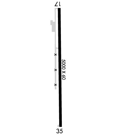
| Lat: N 3727.5 Long: W 10237.1 Elev: 4390 Var: -08 Longest Runway: 5000 | ||
| CTAF: 122.9 | ||
| ||||||||||||||||||||||||||||||||
| ||||||||||||||||||||||||||||||||
| Rwy | Rwy | |||||||
| 5000x60 | 5000' | 5000x60 | 5000' | |||||
| Runway ID | Single Wheel | Double Wheel | Double Tandem Wheel | Dual Double Wheel |
| 17/35 | 12,500 | N/A | N/A | N/A |
| These numbers are Advisory and are not limits. The Airport Manager should have more accurate Weight Limits | ||||
 Airport Diagram might not be current. | |
| Facility Name: | SPRINGFIELD MUNI |
| City Name: | SPRINGFIELD |
| County: | BACA |
| State abbrev: | CO |
| State Name: | COLORADO |
| Ownership: | PUBLICLY OWNED |
| Use: | OPEN TO THE PUBLIC |
| Owner's Name: | TOWN OF SPRINGFIELD |
| Address: | PO BOX 4 |
| SPRINGFIELD, CO 81073 | |
| Owner's Phone: | 719-523-6524 |
| Manager's Name: | BRETT FIGGINS |
| Address: | PO BOX 4 |
| SPRINGFIELD, CO 81073 | |
| Phone: | 719-529-9791 |
| FAA Region: | NORTHWEST MOUNTAIN |
| FAA Field Office: | DEN |
| Date | Sunrise | Sunset |
|---|---|---|
| 06/07/26 Sunday | 5:29 | 20:09 |
| 06/08/26 Monday | 5:29 | 20:10 |
| 06/09/26 Tuesday | 5:29 | 20:10 |
| 06/10/26 Wednesday | 5:29 | 20:11 |
| 06/11/26 Thursday | 5:29 | 20:11 |
| 06/12/26 Friday | 5:29 | 20:12 |
| 06/13/26 Saturday | 5:29 | 20:12 |
| 06/14/26 Sunday | 5:29 | 20:13 |
| 06/15/26 Monday | 5:29 | 20:13 |
| 06/16/26 Tuesday | 5:29 | 20:13 |
| 06/17/26 Wednesday | 5:29 | 20:14 |
| 06/18/26 Thursday | 5:29 | 20:14 |
| 06/19/26 Friday | 5:29 | 20:14 |
| 06/20/26 Saturday | 5:29 | 20:15 |
| Airport Attendance Schedule | UNATTENDED |
| Airport Status | OPERATIONAL (This Status can change at any time - please check NOTAMS) |
| Airport Lighting Schedule | ACTVT PAPI RWY 17 & 35; MIRL RWY 17/35 - CTAF. |
| Airport Storage Available | Tie Downs |
| Extra Services Available | Crop Dusting |
| Wind Indicator | YES - (lighted) |
| Control Tower | NO |
| CTAF Frequency | 122.900 |
| Unicom Frequency | |
| Rotating Beacon Color | WG |
| Segmented Circle | YES |
| Landing Fee | NO |
| Airport Inspected | STATE - performed by STATE AERONAUTICAL PERSONNEL |
| Inspection Date | 04/17/2023 |
| Type of Fuel Available | Grade 100LL |
| Airframe Repair Service | None |
| Power Plant Repair Service | None |
| Latitude | N3727.5 |
| Longitude | W10237.1 (ESTIMATED) |
| Arpt Elevation | 4390ft (SURVEYED) |
| Magnetic Variation | 08E |
| 4 miles N | of SPRINGFIELD |
| Traffic Pattern Altitude | |
| Sectional Chart | WICHITA |
| Operations (Reported) | Yearly | Avg. Daily |
|---|---|---|
| General Aviation Transient | 0 | 0 |
| General Aviation Local | 0 | 0 |
| Air Taxi | 0 | 0 |
| Commerical | 0 | 0 |
| Commuter | 0 | 0 |
| Military | 0 | 0 |
| Aircraft based on Field | |
|---|---|
| General Aviation Singles | 0 |
| General Aviation Multi | 0 |
| Jet Aircraft | 0 |
| General Aviation Helicopters | 0 |
| Military Aircraft | 0 |
| Gliders | 0 |
| Ultralights | 0 |
| FSS on field | NO |
| FSS tie-in | DENVER |
| FSS Phone | 1-800-WX-BRIEF |
| Who issues Notams | DEN |
| Notam D service at airport | YES |
| ARTCC Name | ALBUQUERQUE |
| Airport Certification | |
| Aircraft Rescue & Firefighting Index | None |
| Airport of Entry | No |
| Custom Landing Rights | No |
| Joint Civil/Military | No |
| Military Landing rights | No |
| TWY MKD WITH BLUE & YELLOW REFLECTORS. |
| ALERT; USAF TRNG INVOF COLORADO SPRINGS & PUEBLO COLORADO. |
| FOR CD CTC ALBUQUERQUE ARTCC AT 505-856-4861. |
Airport Communications & Frequencies:
| |||||||
| Runway: 17 | Runway: 35 | ||
| Mag heading: | 171° | Mag heading: | 351° |
| Rwy Slope: | -.05% Down | Rwy Slope: | .05% Up |
| Approach: | Approach: | ||
| Pattern: | Left Traffic | Pattern: | Left Traffic |
| Markings: | NONPRECISION INSTRUMENT | Markings: | NONPRECISION INSTRUMENT |
| Marking Condition: | GOOD | Marking Condition: | GOOD |
| Arresting Dev: | Arresting Dev: | ||
| Lat & Long: | N3727.9 W10237.1 | Lat. & Long.: | N3727.1 W10237.1 |
| Elev: | 4390.2 ft. MSL | Elev: | 4387.8 ft. MSL |
| TCH: | 30 ft. AGL | TCH: | 30 ft. AGL |
| Visual Glide Path: | 3.00 degrees | Visual Glide Path: | 3.00 degrees |
| Displaced Threshold: | No | Displaced Threshold: | No |
| Touchdown Zone: | YES | Touchdown Zone: | YES |
| Touchdown Elev.: | 4390.2 feet | Touchdown Elev.: | 4389.2 feet |
| Visual Glide Slope: | 2-Light PAPI on LEFT side of Runway | Visual Glide Slope: | 2-Light PAPI on LEFT side of Runway |
| RVR Equipment: | RVR Equipment: | ||
| RVV Equipment: | NO | RVV Equipment: | NO |
| Approach Lights: | Approach Lights: | ||
| REIL: | NO | REIL: | NO |
| Centerline Lights: | NO | Centerline Lights: | NO |
| Touchdown lights: | NO | Touchdown lights: | NO |
| Runway Category: | Runway with a Non-precision Approach | Runway Category: | Runway with a Visual Approach |
| Declared Distances: | Declared Distances: |
Thanks for using FltPlan.com
all rights reserved © 1999-2026 by Flight Plan LLC
