| TOWNSEND TOWNSEND MT |
| |
| Lat: N 4619.9 Long: W 11129.0 Elev: 3897 Var: -16 Longest Runway: 4000 | ||
| CTAF: 122.8 | ||
| |||||||||||||||||||||||||||||||||||||||||||||||||||||||||||||
| |||||||||||||||||||||||||||||||||||||||||||||||||||||||||||||
| Rwy | Rwy | |||||||
| 4000x60 | 4000' | 4000x60 | 4000' | |||||
| Runway ID | Single Wheel | Double Wheel | Double Tandem Wheel | Dual Double Wheel |
| 17/35 | 5,000 | N/A | N/A | N/A |
| These numbers are Advisory and are not limits. The Airport Manager should have more accurate Weight Limits | ||||
| FltPlan does not have IFR approach charts available for K8U8. |
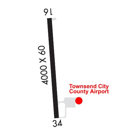 Airport Diagram might not be current. | |
| Facility Name: | TOWNSEND |
| City Name: | TOWNSEND |
| County: | BROADWATER |
| State abbrev: | MT |
| State Name: | MONTANA |
| Ownership: | PUBLICLY OWNED |
| Use: | OPEN TO THE PUBLIC |
| Owner's Name: | TOWNSEND CITY CO AIRPORT |
| Address: | 515 BROADWAY |
| TOWNSEND, MT 59644 | |
| Owner's Phone: | 406-266-9203 |
| Manager's Name: | MIKE FERGUSON |
| Address: | 47 AIRPORT ROAD |
| TOWNSEND, MT 59644 | |
| Phone: | (406) 459-4825 |
| FAA Region: | NORTHWEST MOUNTAIN |
| FAA Field Office: | HLN |
| Date | Sunrise | Sunset |
|---|---|---|
| 09/24/21 Friday | 7:15 | 19:20 |
| 09/25/21 Saturday | 7:16 | 19:18 |
| 09/26/21 Sunday | 7:18 | 19:16 |
| 09/27/21 Monday | 7:19 | 19:14 |
| 09/28/21 Tuesday | 7:20 | 19:12 |
| 09/29/21 Wednesday | 7:22 | 19:10 |
| 09/30/21 Thursday | 7:23 | 19:08 |
| 10/01/21 Friday | 7:24 | 19:06 |
| 10/02/21 Saturday | 7:26 | 19:04 |
| 10/03/21 Sunday | 7:27 | 19:02 |
| 10/04/21 Monday | 7:28 | 19:00 |
| 10/05/21 Tuesday | 7:29 | 18:58 |
| 10/06/21 Wednesday | 7:31 | 18:56 |
| 10/07/21 Thursday | 7:32 | 18:55 |
| Airport Attendance Schedule | UNATTENDED |
| Airport Status | OPERATIONAL (This Status can change at any time - please check NOTAMS) |
| Airport Lighting Schedule | ACTVT MIRL RY 17/35 AND PAPI RYS 17 & 35 - CTAF. |
| Airport Storage Available | Tie Downs |
| Extra Services Available | Crop Dusting |
| Wind Indicator | YES - (lighted) |
| Control Tower | NO |
| CTAF Frequency | 122.800 |
| Unicom Frequency | 122.800 |
| Rotating Beacon Color | CLEAR-GREEN (Light Land Airport) |
| Segmented Circle | NO |
| Landing Fee | NO |
| Airport Inspected | STATE - performed by STATE AERONAUTICAL PERSONNEL |
| Inspection Date | 05/18/2020 |
| Type of Fuel Available | Grade 100LL |
| Airframe Repair Service | NONE |
| Power Plant Repair Service | NONE |
| Latitude | N4619.9 |
| Longitude | W11129.0 (ESTIMATED) |
| Arpt Elevation | 3897ft (ESTIMATED) |
| Magnetic Variation | 16E |
| 2 miles E | of TOWNSEND |
| Traffic Pattern Altitude | |
| Sectional Chart | GREAT FALLS |
| Operations (Reported) | Yearly | Avg. Daily |
|---|---|---|
| General Aviation Transient | 3000 | 8 |
| General Aviation Local | 1500 | 4 |
| Air Taxi | 0 | 0 |
| Commerical | 0 | 0 |
| Commuter | 0 | 0 |
| Military | 10 | 0 |
| Aircraft based on Field | |
|---|---|
| General Aviation Singles | 16 |
| General Aviation Multi | 0 |
| Jet Aircraft | 0 |
| General Aviation Helicopters | 1 |
| Military Aircraft | 0 |
| Gliders | 0 |
| Ultralights | 0 |
| FSS on field | NO |
| FSS tie-in | GREAT FALLS |
| FSS Phone | 1-800-WX-BRIEF |
| Who issues Notams | GTF |
| Notam D service at airport | YES |
| ARTCC Name | SALT LAKE CITY |
| Airport Certification | |
| Aircraft Rescue & Firefighting Index | None |
| Airport of Entry | No |
| Custom Landing Rights | No |
| Joint Civil/Military | No |
| Military Landing rights | No |
| NATIONAL PLAN OF INTEGRATED AIRPORT SYSTEMS (NPIAS) |
| TWY MKD WITH REFLECTORS. |
| INTMT SNOW REMOVAL ON RY 17/35. |
| FOR CD CTC HELENA APCH AT 406-449-5756/5761, WHEN APCH CLSD CTC SALT LAKE ARTCC AT 801-320-2568. |
| Runway: 17 | Runway: 35 | ||
| Mag heading: | N/A | Mag heading: | N/A |
| Rwy Slope: | .45% Up | Rwy Slope: | -.45% Down |
| Approach: | Approach: | ||
| Pattern: | Left Traffic | Pattern: | Left Traffic |
| Markings: | BASIC | Markings: | BASIC |
| Marking Condition: | FAIR | Marking Condition: | FAIR |
| Arresting Dev: | Arresting Dev: | ||
| Lat & Long: | N4620.2 W11129.0 | Lat. & Long.: | N4619.5 W11128.9 |
| Elev: | 3874.7 ft. MSL | Elev: | 3892.6 ft. MSL |
| TCH: | 30 ft. AGL | TCH: | 44 ft. AGL |
| Visual Glide Path: | 3.00 degrees | Visual Glide Path: | 4.00 degrees |
| Displaced Threshold: | No | Displaced Threshold: | No |
| Touchdown Zone: | YES | Touchdown Zone: | YES |
| Touchdown Elev.: | 3888.8 feet | Touchdown Elev.: | 3897.2 feet |
| Visual Glide Slope: | 2-Light PAPI on LEFT side of Runway | Visual Glide Slope: | 2-Light PAPI on LEFT side of Runway |
| RVR Equipment: | RVR Equipment: | ||
| RVV Equipment: | NO | RVV Equipment: | NO |
| Approach Lights: | Approach Lights: | ||
| REIL: | NO | REIL: | NO |
| Centerline Lights: | NO | Centerline Lights: | NO |
| Touchdown lights: | NO | Touchdown lights: | NO |
| Runway Category: | Runway with a Visual Approach | Runway Category: | Runway with a Visual Approach |
| Declared Distances: | Declared Distances: |
Thanks for using FltPlan.com
all rights reserved © 1999-2021 by Flight Plan LLC