
| DANVILLE DANVILLE PA |
| |
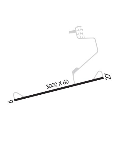
| Lat: N 4056.9 Long: W 07638.6 Elev: 559 Var: +12 Longest Runway: 3000 | ||
| CTAF: 122.8 | ||
| ||||||||||||||||||||||||||||||||
| ||||||||||||||||||||||||||||||||
| Rwy | Rwy | |||||||
| 3000x60 | 3000' | 3000x60 | 3000' | |||||
| Runway ID | Single Wheel | Double Wheel | Double Tandem Wheel | Dual Double Wheel |
| 09/27 | N/A | N/A | N/A | N/A |
| These numbers are Advisory and are not limits. The Airport Manager should have more accurate Weight Limits | ||||
 Airport Diagram might not be current. | |
| Facility Name: | DANVILLE |
| City Name: | DANVILLE |
| County: | NORTHUMBERLAND |
| State abbrev: | PA |
| State Name: | PENNSYLVANIA |
| Ownership: | PUBLICLY OWNED |
| Use: | OPEN TO THE PUBLIC |
| Owner's Name: | NORTHUMBERLAND & MONTOUR JOINT COMM |
| Address: | 1413 SUNBURY ROAD, ST |
| DANVILLE, PA 17821 | |
| Owner's Phone: | 570-274-6190 |
| Manager's Name: | CRAIG LAWLER |
| Address: | 1413 SUNBURY ROAD |
| DANVILLE, PA 17824 | |
| Phone: | 570-274-6190 |
| FAA Region: | EASTERN |
| FAA Field Office: | HAR |
| Date | Sunrise | Sunset |
|---|---|---|
| 09/24/21 Friday | 6:56 | 19:01 |
| 09/25/21 Saturday | 6:57 | 18:59 |
| 09/26/21 Sunday | 6:58 | 18:57 |
| 09/27/21 Monday | 6:59 | 18:56 |
| 09/28/21 Tuesday | 7:00 | 18:54 |
| 09/29/21 Wednesday | 7:01 | 18:52 |
| 09/30/21 Thursday | 7:02 | 18:51 |
| 10/01/21 Friday | 7:03 | 18:49 |
| 10/02/21 Saturday | 7:04 | 18:47 |
| 10/03/21 Sunday | 7:05 | 18:46 |
| 10/04/21 Monday | 7:06 | 18:44 |
| 10/05/21 Tuesday | 7:07 | 18:42 |
| 10/06/21 Wednesday | 7:08 | 18:41 |
| 10/07/21 Thursday | 7:09 | 18:39 |
| Airport Attendance Schedule | 7 Days A Week IRREGULAR; AFT HRS CTC 570-274-6190. |
| Airport Status | OPERATIONAL (This Status can change at any time - please check NOTAMS) |
| Airport Lighting Schedule | ACTVT MIRL RWY 09/27 DRG PERIODS OF DARKNESS ONLY - CTAF. |
| Airport Storage Available | Tie Downs |
| Extra Services Available | NONE |
| Wind Indicator | YES - (unlit) |
| Control Tower | NO |
| CTAF Frequency | 122.800 |
| Unicom Frequency | 122.800 |
| Rotating Beacon Color | CLEAR-GREEN (Light Land Airport) |
| Segmented Circle | YES |
| Landing Fee | NO |
| Airport Inspected | STATE - performed by STATE AERONAUTICAL PERSONNEL |
| Inspection Date | 03/22/2021 |
| Type of Fuel Available | None |
| Airframe Repair Service | MAJOR |
| Power Plant Repair Service | MAJOR |
| Latitude | N4056.9 |
| Longitude | W07638.6 (ESTIMATED) |
| Arpt Elevation | 559ft (ESTIMATED) |
| Magnetic Variation | 12W |
| 3 miles SW | of DANVILLE |
| Traffic Pattern Altitude | |
| Sectional Chart | NEW YORK |
| Operations (Reported) | Yearly | Avg. Daily |
|---|---|---|
| General Aviation Transient | 2000 | 5 |
| General Aviation Local | 7000 | 19 |
| Air Taxi | 0 | 0 |
| Commerical | 0 | 0 |
| Commuter | 0 | 0 |
| Military | 200 | 1 |
| Aircraft based on Field | |
|---|---|
| General Aviation Singles | 38 |
| General Aviation Multi | 0 |
| Jet Aircraft | 0 |
| General Aviation Helicopters | 0 |
| Military Aircraft | 0 |
| Gliders | 0 |
| Ultralights | 1 |
| FSS on field | NO |
| FSS tie-in | WILLIAMSPORT |
| FSS Phone | 1-800-WX-BRIEF |
| Who issues Notams | IPT |
| Notam D service at airport | YES |
| ARTCC Name | NEW YORK |
| Airport Certification | |
| Aircraft Rescue & Firefighting Index | None |
| Airport of Entry | No |
| Custom Landing Rights | No |
| Joint Civil/Military | No |
| Military Landing rights | No |
| DEER & WILDLIFE ON & INVOF ARPT. |
| RC AIRPLANE OPS N OF RWY. |
| FOR CD CTC WILKES-BARRE APCH AT 570-655-2084. |
| LIGHTING NON-STANDARD |
| MAIN RAMP NO PROP WASH INVOF MAIN HNGR DUE TO ACFT PAINTING. |
Airport Communications & Frequencies:
| ||||||||||||||
| Runway: 09 | Runway: 27 | ||
| Mag heading: | N/A | Mag heading: | N/A |
| Rwy Slope: | .45% Up | Rwy Slope: | -.45% Down |
| Approach: | Approach: | ||
| Pattern: | Left Traffic | Pattern: | Left Traffic |
| Markings: | NONPRECISION INSTRUMENT | Markings: | NONPRECISION INSTRUMENT |
| Marking Condition: | FAIR | Marking Condition: | FAIR; THR LGTS DSPLCD 365 FT FM RWY END FOR NGT DISPLACEMENT. RWY END LGTD WITH TWO RED LGTS ON LEFT SIDE (NON STD). |
| Arresting Dev: | Arresting Dev: | ||
| Lat & Long: | N4056.8 W07639.0 | Lat. & Long.: | N4057.0 W07638.3 |
| Elev: | 540.7 ft. MSL | Elev: | 554.1 ft. MSL |
| TCH: | TCH: | ||
| Visual Glide Path: | Visual Glide Path: | ||
| Displaced Threshold: | No | Displaced Threshold: | No |
| Touchdown Zone: | YES | Touchdown Zone: | YES |
| Touchdown Elev.: | 559.0 feet | Touchdown Elev.: | 559.0 feet |
| Visual Glide Slope: | Visual Glide Slope: | ||
| RVR Equipment: | RVR Equipment: | ||
| RVV Equipment: | NO | RVV Equipment: | NO |
| Approach Lights: | Approach Lights: | ||
| REIL: | NO | REIL: | NO |
| Centerline Lights: | NO | Centerline Lights: | NO |
| Touchdown lights: | NO | Touchdown lights: | NO |
| Runway Category: | Runway with a Non-precision Approach | Runway Category: | Runway with a Non-precision Approach |
| Declared Distances: | Declared Distances: | ||
| Obstructions: | TREES | Obstructions: | TREES |
| Marked: | NOT Marked/Lighted | Marked: | NOT Marked/Lighted |
| Clearance slope: | 2:1 | Clearance slope: | 5:1 |
| Obstruction height: | 49 feet AGL | Obstruction height: | 81 feet AGL |
| Dist. from runway: | 314 feet | Dist. from runway: | 644 feet |
| Centerline offset: | 246 right of centerline | Centerline offset: | 293 feet left of centerline |
| Comments: | Comments: |
Thanks for using FltPlan.com
all rights reserved © 1999-2021 by Flight Plan LLC
