
| PAUL C. MILLER-SPARTA SPARTA MI |
| |
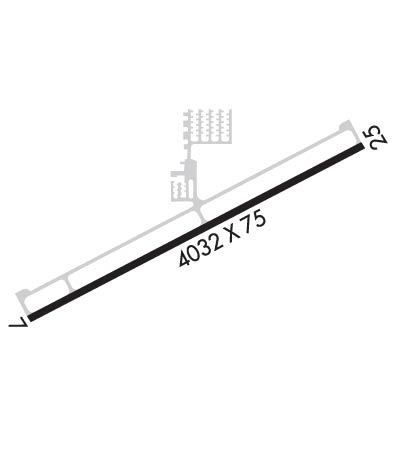
| Lat: N 4307.6 Long: W 08540.7 Elev: 775 Var: +04 Longest Runway: 4033 | ||
| AWOS: 132.95 CTAF: 122.8 | ||
| ||||||||||||||||||||||||||||||||||||||||||||
| ||||||||||||||||||||||||||||||||||||||||||||
| ||||||||||||||||||||||||||||||||||||||||||||
| Rwy | Rwy | |||||||
| 4033x75 | 4033' | 4033x75 | 4033' | |||||
| Runway ID | Single Wheel | Double Wheel | Double Tandem Wheel | Dual Double Wheel |
| 07/25 | 24,000 | N/A | N/A | N/A |
| These numbers are Advisory and are not limits. The Airport Manager should have more accurate Weight Limits | ||||
 Airport Diagram might not be current. | |
| Facility Name: | PAUL C MILLER/SPARTA |
| City Name: | SPARTA |
| County: | KENT |
| State abbrev: | MI |
| State Name: | MICHIGAN |
| Ownership: | PUBLICLY OWNED |
| Use: | OPEN TO THE PUBLIC |
| Owner's Name: | CITY OF SPARTA |
| Address: | 156 E DIVISION ST |
| SPARTA, MI 49345-1330 | |
| Owner's Phone: | 616-887-8251 |
| Manager's Name: | MICHAEL KRZCIOK |
| Address: | 9100 VINTON AVE NW |
| SPARTA, MI 49345-9423 | |
| Phone: | 616-240-4295; CELL 616-240-4295. |
| FAA Region: | GREAT LAKES |
| FAA Field Office: | DET |
| Date | Sunrise | Sunset |
|---|---|---|
| 06/07/26 Sunday | 6:04 | 21:20 |
| 06/08/26 Monday | 6:03 | 21:20 |
| 06/09/26 Tuesday | 6:03 | 21:21 |
| 06/10/26 Wednesday | 6:03 | 21:22 |
| 06/11/26 Thursday | 6:03 | 21:22 |
| 06/12/26 Friday | 6:03 | 21:23 |
| 06/13/26 Saturday | 6:02 | 21:23 |
| 06/14/26 Sunday | 6:02 | 21:24 |
| 06/15/26 Monday | 6:02 | 21:24 |
| 06/16/26 Tuesday | 6:02 | 21:24 |
| 06/17/26 Wednesday | 6:02 | 21:25 |
| 06/18/26 Thursday | 6:03 | 21:25 |
| 06/19/26 Friday | 6:03 | 21:25 |
| 06/20/26 Saturday | 6:03 | 21:26 |
| Airport Attendance Schedule | MON-FRI 0800-1700 |
| Airport Status | OPERATIONAL (This Status can change at any time - please check NOTAMS) |
| Airport Lighting Schedule | ACTVT REIL RWY 07 & 25; PAPI RWY 07 & 25; MIRL RWY 07/25 - CTAF. |
| Airport Storage Available | Tie Downs, Hanger |
| Extra Services Available | Avionics, Flight Instruction, Aircraft Rental |
| Wind Indicator | YES - (lighted) |
| Control Tower | NO |
| CTAF Frequency | 122.800 |
| Unicom Frequency | 122.800 |
| Rotating Beacon Color | WG |
| Segmented Circle | YES |
| Landing Fee | NO |
| Airport Inspected | STATE - performed by STATE AERONAUTICAL PERSONNEL |
| Inspection Date | 07/09/2025 |
| Type of Fuel Available | Grade 100LL, JET AMOGAS; -10100LL & JET A+ AVBL H24 SELF SVC VIA CREDIT CARD. |
| Airframe Repair Service | MINOR; RPRS AVBL ON CALL 616-706-4421. |
| Power Plant Repair Service | MINOR |
| Latitude | N4307.6 |
| Longitude | W08540.7 (ESTIMATED) |
| Arpt Elevation | 774ft (SURVEYED) |
| Magnetic Variation | 04W |
| 2 miles SE | of SPARTA |
| Traffic Pattern Altitude | |
| Sectional Chart | CHICAGO |
| Operations (Reported) | Yearly | Avg. Daily |
|---|---|---|
| General Aviation Transient | 0 | 0 |
| General Aviation Local | 0 | 0 |
| Air Taxi | 0 | 0 |
| Commerical | 0 | 0 |
| Commuter | 0 | 0 |
| Military | 0 | 0 |
| Aircraft based on Field | |
|---|---|
| General Aviation Singles | 0 |
| General Aviation Multi | 0 |
| Jet Aircraft | 0 |
| General Aviation Helicopters | 0 |
| Military Aircraft | 0 |
| Gliders | 0 |
| Ultralights | 0 |
| FSS on field | NO |
| FSS tie-in | LANSING |
| FSS Phone | 1-800-WX-BRIEF |
| Who issues Notams | 8D4 |
| Notam D service at airport | YES |
| ARTCC Name | CHICAGO |
| Airport Certification | |
| Aircraft Rescue & Firefighting Index | None |
| Airport of Entry | No |
| Custom Landing Rights | No |
| Joint Civil/Military | No |
| Military Landing rights | No |
| NATIONAL PLAN OF INTEGRATED AIRPORT SYSTEMS (NPIAS) |
| DEER & LRG BIRDS ON & INVOF ARPT. |
| ADMIN BLDG ACES: 5-3-2-1. |
| FOR CD CTC GREAT LAKES APCH AT 269-459-3344, WHEN APCH CLSD CTC CHICAGO ARTCC AT 630-906-8921. |
Airport Communications & Frequencies:
| |||||||||||||||||
| Runway: 07 | Runway: 25 | ||
| Mag heading: | 66° | Mag heading: | 246° |
| Rwy Slope: | -.74% Down | Rwy Slope: | .74% Up |
| Approach: | Approach: | ||
| Pattern: | Left Traffic | Pattern: | Left Traffic |
| Markings: | NONPRECISION INSTRUMENT | Markings: | NONPRECISION INSTRUMENT |
| Marking Condition: | GOOD | Marking Condition: | GOOD |
| Arresting Dev: | Arresting Dev: | ||
| Lat & Long: | N4307.5 W08541.1 | Lat. & Long.: | N4307.8 W08540.3 |
| Elev: | 774.4 ft. MSL | Elev: | 744.7 ft. MSL |
| TCH: | 42 ft. AGL | TCH: | 42 ft. AGL |
| Visual Glide Path: | 3.50 degrees | Visual Glide Path: | 3.50 degrees |
| Displaced Threshold: | No | Displaced Threshold: | No |
| Touchdown Zone: | YES | Touchdown Zone: | YES |
| Touchdown Elev.: | 774.7 feet | Touchdown Elev.: | 764.0 feet |
| Visual Glide Slope: | 4-Light PAPI on LEFT side of Runway | Visual Glide Slope: | 4-Light PAPI on RIGHT side of Runway |
| RVR Equipment: | RVR Equipment: | ||
| RVV Equipment: | NO | RVV Equipment: | NO |
| Approach Lights: | Approach Lights: | ||
| REIL: | YES | REIL: | YES |
| Centerline Lights: | NO | Centerline Lights: | NO |
| Touchdown lights: | NO | Touchdown lights: | NO |
| Runway Category: | Runway with a Non-precision Approach | Runway Category: | Runway with a Non-precision Approach |
| Declared Distances: | Declared Distances: | ||
| Obstructions: | TREE | Obstructions: | TREE |
| Marked: | NOT Marked/Lighted | Marked: | NOT Marked/Lighted |
| Clearance slope: | 10:1 | Clearance slope: | 15:1 |
| Obstruction height: | 27 feet AGL | Obstruction height: | 34 feet AGL |
| Dist. from runway: | 471 feet | Dist. from runway: | 716 feet |
| Centerline offset: | 166 left of centerline | Centerline offset: | 342 feet right of centerline |
| Comments: | Comments: |
Thanks for using FltPlan.com
all rights reserved © 1999-2026 by Flight Plan LLC
