
| TWIN LAKES MOCKSVILLE NC |
| |
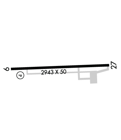
| Lat: N 3554.9 Long: W 08027.4 Elev: 818 Var: +06 Longest Runway: 2943 | ||
| CTAF: 122.7 | ||
| |||||||||||||||||||||||||||||||||||||||||||||||||||||||||||||
| |||||||||||||||||||||||||||||||||||||||||||||||||||||||||||||
| |||||||||||||||||||||||||||||||||||||||||||||||||||||||||||||
| Rwy | Rwy | |||||||
| 2943x50 | 2943' | 2943x50 | 2943' | |||||
| Runway ID | Single Wheel | Double Wheel | Double Tandem Wheel | Dual Double Wheel |
| 09/27 | 12,500 | N/A | N/A | N/A |
| These numbers are Advisory and are not limits. The Airport Manager should have more accurate Weight Limits | ||||
 Airport Diagram might not be current. | |
| Facility Name: | TWIN LAKES |
| City Name: | MOCKSVILLE |
| County: | DAVIE |
| State abbrev: | NC |
| State Name: | NORTH CAROLINA |
| Ownership: | PRIVATELY OWNED |
| Use: | OPEN TO THE PUBLIC |
| Owner's Name: | DR. PHILIP MARTIN |
| Address: | 3434 EDWARDS MILL RD, SUITE 112-341 |
| RALEIGH, NC 27612 | |
| Owner's Phone: | 919-571-0081 |
| Manager's Name: | BRIAN MEADOWS |
| Address: | 1105 FORK BIXBY RD |
| ADVANCE, NC 27006 | |
| Phone: | 336-998-8101 |
| FAA Region: | SOUTHERN |
| FAA Field Office: | MEM |
| Date | Sunrise | Sunset |
|---|---|---|
| 09/24/21 Friday | 7:11 | 19:16 |
| 09/25/21 Saturday | 7:12 | 19:15 |
| 09/26/21 Sunday | 7:13 | 19:13 |
| 09/27/21 Monday | 7:13 | 19:12 |
| 09/28/21 Tuesday | 7:14 | 19:10 |
| 09/29/21 Wednesday | 7:15 | 19:09 |
| 09/30/21 Thursday | 7:16 | 19:07 |
| 10/01/21 Friday | 7:17 | 19:06 |
| 10/02/21 Saturday | 7:17 | 19:04 |
| 10/03/21 Sunday | 7:18 | 19:03 |
| 10/04/21 Monday | 7:19 | 19:02 |
| 10/05/21 Tuesday | 7:20 | 19:00 |
| 10/06/21 Wednesday | 7:21 | 18:59 |
| 10/07/21 Thursday | 7:22 | 18:57 |
| Airport Attendance Schedule | 7 Days A Week 0800-1700 |
| Airport Status | OPERATIONAL (This Status can change at any time - please check NOTAMS) |
| Airport Lighting Schedule | SS-SR |
| Airport Storage Available | Tie Downs |
| Extra Services Available | Avionics, Flight Instruction, Aircraft Sales |
| Wind Indicator | YES - (unlit) |
| Control Tower | NO |
| CTAF Frequency | 122.700 |
| Unicom Frequency | 122.700 |
| Rotating Beacon Color | CLEAR-GREEN (Light Land Airport) |
| Segmented Circle | NO |
| Landing Fee | NO |
| Airport Inspected | STATE - performed by STATE AERONAUTICAL PERSONNEL |
| Inspection Date | 05/10/2019 |
| Type of Fuel Available | Grade 100LL; -1024 HR SELF SERVICE WITH CC |
| Airframe Repair Service | MAJOR |
| Power Plant Repair Service | MAJOR |
| Latitude | N3554.9 |
| Longitude | W08027.4 (ESTIMATED) |
| Arpt Elevation | 818ft (SURVEYED) |
| Magnetic Variation | 06W |
| 5 miles NE | of MOCKSVILLE |
| Traffic Pattern Altitude | |
| Sectional Chart | CHARLOTTE |
| Operations (Reported) | Yearly | Avg. Daily |
|---|---|---|
| General Aviation Transient | 5000 | 14 |
| General Aviation Local | 24000 | 66 |
| Air Taxi | 0 | 0 |
| Commerical | 0 | 0 |
| Commuter | 0 | 0 |
| Military | 1000 | 3 |
| Aircraft based on Field | |
|---|---|
| General Aviation Singles | 88 |
| General Aviation Multi | 2 |
| Jet Aircraft | 0 |
| General Aviation Helicopters | 0 |
| Military Aircraft | 0 |
| Gliders | 0 |
| Ultralights | 0 |
| FSS on field | NO |
| FSS tie-in | RALEIGH |
| FSS Phone | 1-800-WX-BRIEF |
| Who issues Notams | RDU |
| Notam D service at airport | YES |
| ARTCC Name | ATLANTA |
| Airport Certification | |
| Aircraft Rescue & Firefighting Index | None |
| Airport of Entry | No |
| Custom Landing Rights | No |
| Joint Civil/Military | No |
| Military Landing rights | No |
| THIS AIRPORT HAS BEEN SURVEYED BY THE NATIONAL GEODETIC SURVEY. |
| RY 09 -18 FT DROP-OFF 150 FT FROM THR LEFT & RIGHT OF CNTRLN. |
| RY 09 UPHILL GRADE. |
| DEER/MIGRATORY BIRDS OCNLLY ON ARPT. |
| FOR CD CTC GREENSBORO APCH AT 336-333-5119. |
| FOR AFT HRS SVC CTC 336-998-2126. |
Airport Communications & Frequencies:
| ||||||||||||||
| Runway: 09 | Runway: 27 | ||
| Mag heading: | 94° | Mag heading: | 274° |
| Rwy Slope: | 1.53% Up | Rwy Slope: | -1.53% Down |
| Approach: | Approach: | ||
| Pattern: | Left Traffic | Pattern: | Left Traffic |
| Markings: | NONSTANDARD | Markings: | NONSTANDARD |
| Marking Condition: | GOOD; RY 09 MARKINGS NONSTANDARD DUE TO SIZE AND LOCATION. | Marking Condition: | GOOD; RY 27 MARKINGS NONSTANDARD DUE TO SIZE AND LOCATION |
| Arresting Dev: | Arresting Dev: | ||
| Lat & Long: | N3554.9 W08027.7 | Lat. & Long.: | N3554.9 W08027.1 |
| Elev: | 773.0 ft. MSL | Elev: | 818.0 ft. MSL |
| TCH: | 49 ft. AGL | TCH: | |
| Visual Glide Path: | 3.50 degrees | Visual Glide Path: | |
| Displaced Threshold: | No | Displaced Threshold: | No |
| Touchdown Zone: | YES | Touchdown Zone: | YES |
| Touchdown Elev.: | 818.0 feet | Touchdown Elev.: | 818.0 feet |
| Visual Glide Slope: | 2-Light PAPI on LEFT side of Runway | Visual Glide Slope: | |
| RVR Equipment: | RVR Equipment: | ||
| RVV Equipment: | NO | RVV Equipment: | NO |
| Approach Lights: | Approach Lights: | ||
| REIL: | NO | REIL: | NO |
| Centerline Lights: | NO | Centerline Lights: | NO |
| Touchdown lights: | NO | Touchdown lights: | NO |
| Runway Category: | Runway with a Non-precision Approach | Runway Category: | Runway with a Visual Approach |
| Declared Distances: | Declared Distances: | ||
| Obstructions: | TREES | Obstructions: | TREES |
| Marked: | NOT Marked/Lighted | Marked: | NOT Marked/Lighted |
| Clearance slope: | 3:1 | Clearance slope: | 5:1 |
| Obstruction height: | 57 feet AGL | Obstruction height: | 79 feet AGL |
| Dist. from runway: | 415 feet | Dist. from runway: | 620 feet |
| Centerline offset: | 109 right of centerline | Centerline offset: | 118 feet left of centerline |
| Comments: | HAS 6 FT BUSHES STARTING 0-100 FT FM THR OFFSET 13 FT R OF CNTRLN AND HAS 20 FT BUSHES 0-100 FT FM THR OFFSET 50 FT L OF CNTRLN. | Comments: |
Thanks for using FltPlan.com
all rights reserved © 1999-2021 by Flight Plan LLC

