
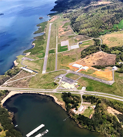
| GUNTERSVILLE MUNI - JOE STARNE GUNTERSVILLE AL |
| |
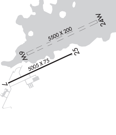
| Lat: N 3424.4 Long: W 08615.7 Elev: 615 Var: +04 Longest Runway: 5005 | ||
| CTAF: 122.8 | ||
| ||||||||||||||||||||||||||||||||||||||||||||
| ||||||||||||||||||||||||||||||||||||||||||||
| Rwy | Rwy | |||||||
| 5500x200 | 5500' | 5500x200 | 5500' | |||||
| 5005x75 | 5005' | 5005x75 | 5005' | |||||
| Runway ID | Single Wheel | Double Wheel | Double Tandem Wheel | Dual Double Wheel |
| 06W/24W | N/A | N/A | N/A | N/A |
| 07/25 | 24,000 | N/A | N/A | N/A |
| These numbers are Advisory and are not limits. The Airport Manager should have more accurate Weight Limits | ||||
 Airport Diagram might not be current. | |
| Facility Name: | GUNTERSVILLE MUNI/JOE STARNES FLD |
| City Name: | GUNTERSVILLE |
| County: | MARSHALL |
| State abbrev: | AL |
| State Name: | ALABAMA |
| Ownership: | PUBLICLY OWNED |
| Use: | OPEN TO THE PUBLIC |
| Owner's Name: | CITY OF GUNTERSVILLE |
| Address: | 341 GUNTER AVE |
| GUNTERSVILLE, AL 35976 | |
| Owner's Phone: | 256-571-7560 |
| Manager's Name: | GARY MCILQUHAM |
| Address: | 405 BUCK ISLAND RD |
| GUNTERSVILLE, AL 35976 | |
| Phone: | (256) 582-6087 |
| FAA Region: | SOUTHERN |
| FAA Field Office: | JAN |
| Date | Sunrise | Sunset |
|---|---|---|
| 06/08/26 Monday | 5:32 | 19:56 |
| 06/09/26 Tuesday | 5:32 | 19:56 |
| 06/10/26 Wednesday | 5:32 | 19:57 |
| 06/11/26 Thursday | 5:32 | 19:57 |
| 06/12/26 Friday | 5:32 | 19:58 |
| 06/13/26 Saturday | 5:32 | 19:58 |
| 06/14/26 Sunday | 5:32 | 19:59 |
| 06/15/26 Monday | 5:32 | 19:59 |
| 06/16/26 Tuesday | 5:32 | 19:59 |
| 06/17/26 Wednesday | 5:32 | 20:00 |
| 06/18/26 Thursday | 5:32 | 20:00 |
| 06/19/26 Friday | 5:33 | 20:00 |
| 06/20/26 Saturday | 5:33 | 20:00 |
| 06/21/26 Sunday | 5:33 | 20:01 |
| Airport Attendance Schedule | MON - SAT 0800-1700; MGR ON CALL AFT HRS. |
| Airport Status | OPERATIONAL (This Status can change at any time - please check NOTAMS) |
| Airport Lighting Schedule | ACTVT REIL RWY 7 & 25; PAPI RWY 25; MIRL RWY 7/25 - CTAF. |
| Airport Storage Available | Tie Downs |
| Extra Services Available | Aircraft Rental |
| Wind Indicator | YES - (unlit) |
| Control Tower | NO |
| CTAF Frequency | 122.800 |
| Unicom Frequency | 122.800 |
| Rotating Beacon Color | WG |
| Segmented Circle | YES |
| Landing Fee | NO |
| Airport Inspected | STATE - performed by STATE AERONAUTICAL PERSONNEL |
| Inspection Date | 09/09/2025 |
| Type of Fuel Available | Grade 100LL, JET A; -1024/7 SELF-SVC AVGAS & FULL SVC JET-A DURNG NML OPN HRS. |
| Airframe Repair Service | MAJOR |
| Power Plant Repair Service | MAJOR |
| Latitude | N3424.4 |
| Longitude | W08615.7 (ESTIMATED) |
| Arpt Elevation | 614ft (SURVEYED) |
| Magnetic Variation | 04W |
| 3 miles NE | of GUNTERSVILLE |
| Traffic Pattern Altitude | |
| Sectional Chart | ATLANTA |
| Operations (Reported) | Yearly | Avg. Daily |
|---|---|---|
| General Aviation Transient | 0 | 0 |
| General Aviation Local | 0 | 0 |
| Air Taxi | 0 | 0 |
| Commerical | 0 | 0 |
| Commuter | 0 | 0 |
| Military | 0 | 0 |
| Aircraft based on Field | |
|---|---|
| General Aviation Singles | 0 |
| General Aviation Multi | 0 |
| Jet Aircraft | 0 |
| General Aviation Helicopters | 0 |
| Military Aircraft | 0 |
| Gliders | 0 |
| Ultralights | 0 |
| FSS on field | NO |
| FSS tie-in | ANNISTON |
| FSS Phone | 1-800-WX-BRIEF |
| Who issues Notams | ANB |
| Notam D service at airport | YES |
| ARTCC Name | MEMPHIS |
| Airport Certification | |
| Aircraft Rescue & Firefighting Index | None |
| Airport of Entry | No |
| Custom Landing Rights | No |
| Joint Civil/Military | No |
| Military Landing rights | YES |
| NATIONAL PLAN OF INTEGRATED AIRPORT SYSTEMS (NPIAS) |
| CONVEYANCE UNDER SCETION 16, FEDERAL AIRPORT ACT OF 1946 OR SECTION 23, AIRPORT AND AIRWAY DEVELOPMENT ACT OF 1970 |
| GRANT AGREEMENT HAS EXPIRED; HOWEVER, AGREEMENT REMAINS IN EFFECT FOR THIS FACILITY AS LONG AS IT IS PUBLIC USE. |
| DEER, BIRDS, AND COYOTES ON & INVOF ARPT. |
| FOR CD CTC HUNTSVILLE APCH AT 256-542-2070, WHEN APCH CLSD CTC MEMPHIS ARTCC AT 901-368-8453/8449. |
Airport Communications & Frequencies:
| |||||||||||||||||
| Runway: 06W | Runway: 24W | ||
| Mag heading: | 69° | Mag heading: | 249° |
| Rwy Slope: | .00% | Rwy Slope: | .00% |
| Approach: | Approach: | ||
| Pattern: | Left Traffic | Pattern: | Left Traffic |
| Markings: | Markings: | ||
| Marking Condition: | Marking Condition: | ||
| Arresting Dev: | Arresting Dev: | ||
| Lat & Long: | N3424.4 W08616.0 | Lat. & Long.: | N3424.7 W08615.0 |
| Elev: | 595.0 ft. MSL | Elev: | 595.0 ft. MSL |
| TCH: | TCH: | ||
| Visual Glide Path: | Visual Glide Path: | ||
| Displaced Threshold: | No | Displaced Threshold: | No |
| Touchdown Zone: | YES | Touchdown Zone: | YES |
| Touchdown Elev.: | 595.0 feet | Touchdown Elev.: | 595.0 feet |
| Visual Glide Slope: | Visual Glide Slope: | ||
| RVR Equipment: | RVR Equipment: | ||
| RVV Equipment: | NO | RVV Equipment: | NO |
| Approach Lights: | Approach Lights: | ||
| REIL: | NO | REIL: | NO |
| Centerline Lights: | NO | Centerline Lights: | NO |
| Touchdown lights: | NO | Touchdown lights: | NO |
| Runway Category: | Runway Category: | ||
| Declared Distances: | Declared Distances: |
| Runway: 07 | Runway: 25 | ||
| Mag heading: | 69° | Mag heading: | 249° |
| Rwy Slope: | .09% Up | Rwy Slope: | -.09% Down |
| Approach: | Approach: | ||
| Pattern: | Left Traffic | Pattern: | Left Traffic |
| Markings: | NONPRECISION INSTRUMENT | Markings: | NONPRECISION INSTRUMENT |
| Marking Condition: | GOOD | Marking Condition: | GOOD |
| Arresting Dev: | Arresting Dev: | ||
| Lat & Long: | N3424.0 W08616.3 | Lat. & Long.: | N3424.4 W08615.4 |
| Elev: | 610.0 ft. MSL | Elev: | 614.6 ft. MSL |
| TCH: | TCH: | 50 ft. AGL | |
| Visual Glide Path: | Visual Glide Path: | 3.35 degrees | |
| Displaced Threshold: | No | Displaced Threshold: | No |
| Touchdown Zone: | YES | Touchdown Zone: | YES |
| Touchdown Elev.: | 610.1 feet | Touchdown Elev.: | 614.6 feet |
| Visual Glide Slope: | Visual Glide Slope: | 2-Light PAPI on LEFT side of Runway | |
| RVR Equipment: | RVR Equipment: | ||
| RVV Equipment: | NO | RVV Equipment: | NO |
| Approach Lights: | Approach Lights: | ||
| REIL: | YES | REIL: | YES |
| Centerline Lights: | NO | Centerline Lights: | NO |
| Touchdown lights: | NO | Touchdown lights: | NO |
| Runway Category: | Runway with a Non-precision Approach having visibility minimums greater than 3/4 mile | Runway Category: | Runway with a Non-precision Approach having visibility minimums greater than 3/4 mile |
| Declared Distances: | Declared Distances: | ||
| Obstructions: | TREE | Obstructions: | TREES |
| Marked: | NOT Marked/Lighted | Marked: | NOT Marked/Lighted |
| Clearance slope: | 8:1 | Clearance slope: | 2:1 |
| Obstruction height: | 45 feet AGL | Obstruction height: | 21 feet AGL |
| Dist. from runway: | 604 feet | Dist. from runway: | 248 feet |
| Centerline offset: | 290 right of centerline | Centerline offset: | 9013 feet right of centerline |
| Comments: | Comments: |
Thanks for using FltPlan.com
all rights reserved © 1999-2026 by Flight Plan LLC