
| ALBERTVILLE REGL-BRUMLIK ALBERTVILLE AL |
| |
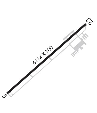
| Lat: N 3413.7 Long: W 08615.3 Elev: 1032 Var: +02 Longest Runway: 6114 | ||
| AWOS: 119.57 CTAF: 123.0 | ||
| ||||||||||||||||||||||||||||||||||||||||||||
| ||||||||||||||||||||||||||||||||||||||||||||
| ||||||||||||||||||||||||||||||||||||||||||||
| Rwy | Rwy | |||||||
| 6114x100 | 6114' | 6114x100 | 6114' | |||||
| Runway ID | Single Wheel | Double Wheel | Double Tandem Wheel | Dual Double Wheel |
| 05/23 | 60,000 | 90,000 | 130,000 | N/A |
| These numbers are Advisory and are not limits. The Airport Manager should have more accurate Weight Limits | ||||
 Airport Diagram might not be current. | |
| Facility Name: | ALBERTVILLE RGNL/THOMAS J BRUMLIK FLD |
| City Name: | ALBERTVILLE |
| County: | MARSHALL |
| State abbrev: | AL |
| State Name: | ALABAMA |
| Ownership: | PUBLICLY OWNED |
| Use: | OPEN TO THE PUBLIC |
| Owner's Name: | CITY OF ALBERTVILLE |
| Address: | PO BOX 1248 |
| ALBERTVILLE, AL 35950 | |
| Owner's Phone: | (256) 891-8200 |
| Manager's Name: | MARK CHESNUT |
| Address: | P. O. BOX 1248 |
| ALBERTVILLE, AL 35950 | |
| Phone: | 256-960-9012; AFT HRS 256-302-6082 OR 256-302-7886. |
| FAA Region: | SOUTHERN |
| FAA Field Office: | JAN |
| Date | Sunrise | Sunset |
|---|---|---|
| 04/16/25 Wednesday | 6:13 | 19:17 |
| 04/17/25 Thursday | 6:12 | 19:18 |
| 04/18/25 Friday | 6:10 | 19:19 |
| 04/19/25 Saturday | 6:09 | 19:20 |
| 04/20/25 Sunday | 6:08 | 19:20 |
| 04/21/25 Monday | 6:07 | 19:21 |
| 04/22/25 Tuesday | 6:06 | 19:22 |
| 04/23/25 Wednesday | 6:05 | 19:23 |
| 04/24/25 Thursday | 6:03 | 19:24 |
| 04/25/25 Friday | 6:02 | 19:24 |
| 04/26/25 Saturday | 6:01 | 19:25 |
| 04/27/25 Sunday | 6:00 | 19:26 |
| 04/28/25 Monday | 5:59 | 19:27 |
| 04/29/25 Tuesday | 5:58 | 19:27 |
| Airport Attendance Schedule | MON-SAT 0700-DUSK, SUN 1230-DUSK |
| Airport Status | OPERATIONAL (This Status can change at any time - please check NOTAMS) |
| Airport Lighting Schedule | DUSK - 2300. MIRL RWY 05/23 PRESET MED INTST DUSK-2300; TO INCR INTST - CTAF. AFT 2300 ACTVT REIL RWY 23; PAPI RWYS 05 & 23; MIRL RWY 05/23 - CTAF. |
| Airport Storage Available | Tie Downs |
| Extra Services Available | Flight Instruction, Aircraft Rental |
| Wind Indicator | YES - (lighted) |
| Control Tower | NO |
| CTAF Frequency | 123.000 |
| Unicom Frequency | 123.000 |
| Rotating Beacon Color | WG |
| Segmented Circle | YES |
| Landing Fee | NO |
| Airport Inspected | STATE - performed by STATE AERONAUTICAL PERSONNEL |
| Inspection Date | 03/20/2024 |
| Type of Fuel Available | Grade 100LL, JET A |
| Airframe Repair Service | MAJOR |
| Power Plant Repair Service | MAJOR |
| Latitude | N3413.7 |
| Longitude | W08615.3 (ESTIMATED) |
| Arpt Elevation | 1032ft (SURVEYED) |
| Magnetic Variation | 02W |
| 3 miles SW | of ALBERTVILLE |
| Traffic Pattern Altitude | |
| Sectional Chart | ATLANTA |
| Operations (Reported) | Yearly | Avg. Daily |
|---|---|---|
| General Aviation Transient | 0 | 0 |
| General Aviation Local | 0 | 0 |
| Air Taxi | 0 | 0 |
| Commerical | 0 | 0 |
| Commuter | 0 | 0 |
| Military | 0 | 0 |
| Aircraft based on Field | |
|---|---|
| General Aviation Singles | 0 |
| General Aviation Multi | 0 |
| Jet Aircraft | 0 |
| General Aviation Helicopters | 0 |
| Military Aircraft | 0 |
| Gliders | 0 |
| Ultralights | 0 |
| FSS on field | NO |
| FSS tie-in | ANNISTON |
| FSS Phone | 1-800-WX-BRIEF |
| Who issues Notams | 8A0 |
| Notam D service at airport | YES |
| ARTCC Name | ATLANTA |
| Airport Certification | |
| Aircraft Rescue & Firefighting Index | None |
| Airport of Entry | No |
| Custom Landing Rights | No |
| Joint Civil/Military | No |
| Military Landing rights | No |
| NATIONAL PLAN OF INTEGRATED AIRPORT SYSTEMS (NPIAS) |
| GRANT AGREEMENTS UNDER FAAP/ADAP/AIP |
| ASSURANCES PURSUANT TO TITLE VI, CIVIL RIGHTS ACT OF 1964 |
| FOR CD CTC BIRMINGHAM APCH AT 205-769-3890. |
| RWY 05/2 3 PCR VALUE: 401/F/D/X/T |
Airport Communications & Frequencies:
| |||||||||||||||||
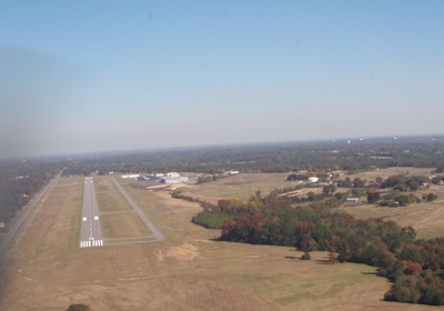
| Runway: 05 | Runway: 23 | ||
| Mag heading: | 50° | Mag heading: | 230° |
| Rwy Slope: | .48% Up | Rwy Slope: | -.48% Down |
| Approach: | Approach: | ||
| Pattern: | Left Traffic | Pattern: | Left Traffic |
| Markings: | NONPRECISION INSTRUMENT | Markings: | NONPRECISION INSTRUMENT |
| Marking Condition: | GOOD | Marking Condition: | GOOD |
| Arresting Dev: | Arresting Dev: | ||
| Lat & Long: | N3413.4 W08615.8 | Lat. & Long.: | N3414.1 W08614.9 |
| Elev: | 1002.7 ft. MSL | Elev: | 1032.3 ft. MSL |
| TCH: | 42 ft. AGL | TCH: | 42 ft. AGL |
| Visual Glide Path: | 3.00 degrees | Visual Glide Path: | 3.00 degrees |
| Displaced Threshold: | No | Displaced Threshold: | No |
| Touchdown Zone: | YES | Touchdown Zone: | YES |
| Touchdown Elev.: | 1015.1 feet | Touchdown Elev.: | 1032.3 feet |
| Visual Glide Slope: | 2-Light PAPI on LEFT side of Runway | Visual Glide Slope: | 2-Light PAPI on LEFT side of Runway |
| RVR Equipment: | RVR Equipment: | ||
| RVV Equipment: | NO | RVV Equipment: | NO |
| Approach Lights: | Approach Lights: | ||
| REIL: | NO | REIL: | YES |
| Centerline Lights: | NO | Centerline Lights: | NO |
| Touchdown lights: | NO | Touchdown lights: | NO |
| Runway Category: | Runway with a Non-precision Approach having visibility minimums greater than 3/4 mile | Runway Category: | Runway with a Non-precision Approach having visibility minimums greater than 3/4 mile |
| Declared Distances: | Declared Distances: | ||
| Obstructions: | TREES | Obstructions: | |
| Marked: | NOT Marked/Lighted | Marked: | |
| Clearance slope: | 22:1 | Clearance slope: | 34:1 |
| Obstruction height: | 57 feet AGL | Obstruction height: | |
| Dist. from runway: | 1506 feet | Dist. from runway: | |
| Centerline offset: | 316 left of centerline | Centerline offset: | |
| Comments: | Comments: |
Thanks for using FltPlan.com
all rights reserved © 1999-2025 by Flight Plan LLC