
| BLACKHAWK AIRFIELD MADISON WI |
| |
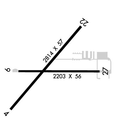
| Lat: N 4306.3 Long: W 08911.1 Elev: 920 Var: +03 Longest Runway: 2814 | ||
| CTAF: 122.7 | ||
| ||||||||||||||||||||||||||||||||
| ||||||||||||||||||||||||||||||||
| Rwy | Rwy | |||||||
| 2814x57 | 2814' | 2814x57 | 2554' | |||||
| 2203x56 | 2203' | 2203x56 | 1973' | |||||
| Runway ID | Single Wheel | Double Wheel | Double Tandem Wheel | Dual Double Wheel |
| 04/22 | N/A | N/A | N/A | N/A |
| 09/27 | N/A | N/A | N/A | N/A |
| These numbers are Advisory and are not limits. The Airport Manager should have more accurate Weight Limits | ||||
 Airport Diagram might not be current. | |
| Facility Name: | BLACKHAWK AIRFIELD |
| City Name: | MADISON |
| County: | DANE |
| State abbrev: | WI |
| State Name: | WISCONSIN |
| Ownership: | PRIVATELY OWNED |
| Use: | OPEN TO THE PUBLIC |
| Owner's Name: | BLACKHAWK AIRFIELD INC |
| Address: | 2534 S FISH HATCHERY ROAD |
| FITCHBURG, WI 53711 | |
| Owner's Phone: | (608) 334-4932 |
| Manager's Name: | CHERYL STRASSMAN |
| Address: | 2534 S FISH HATCHERY ROAD; EMAIL ADDRESS: STRASS32@AMERITECH.NET (ALL LOWER CASE) |
| FITCHBURG, WI 53711 | |
| Phone: | (608) 334-4932 |
| FAA Region: | GREAT LAKES |
| FAA Field Office: | CHI |
| Date | Sunrise | Sunset |
|---|---|---|
| 09/24/21 Friday | 6:46 | 18:51 |
| 09/25/21 Saturday | 6:47 | 18:49 |
| 09/26/21 Sunday | 6:48 | 18:47 |
| 09/27/21 Monday | 6:49 | 18:45 |
| 09/28/21 Tuesday | 6:50 | 18:44 |
| 09/29/21 Wednesday | 6:52 | 18:42 |
| 09/30/21 Thursday | 6:53 | 18:40 |
| 10/01/21 Friday | 6:54 | 18:38 |
| 10/02/21 Saturday | 6:55 | 18:37 |
| 10/03/21 Sunday | 6:56 | 18:35 |
| 10/04/21 Monday | 6:57 | 18:33 |
| 10/05/21 Tuesday | 6:58 | 18:31 |
| 10/06/21 Wednesday | 7:00 | 18:30 |
| 10/07/21 Thursday | 7:01 | 18:28 |
| Airport Attendance Schedule | UNATTND |
| Airport Status | OPERATIONAL (This Status can change at any time - please check NOTAMS) |
| Airport Lighting Schedule | SS-SR |
| Airport Storage Available | Tie Downs, Hanger |
| Extra Services Available | NONE |
| Wind Indicator | NONE |
| Control Tower | NO |
| CTAF Frequency | 122.700 |
| Unicom Frequency | 122.700 |
| Rotating Beacon Color | CLEAR-GREEN (Light Land Airport) |
| Segmented Circle | YES |
| Landing Fee | NO |
| Airport Inspected | STATE - performed by STATE AERONAUTICAL PERSONNEL |
| Inspection Date | 07/02/2019 |
| Type of Fuel Available | None |
| Airframe Repair Service | NONE |
| Power Plant Repair Service | NONE |
| Latitude | N4306.3 |
| Longitude | W08911.1 (ESTIMATED) |
| Arpt Elevation | 920ft (SURVEYED) |
| Magnetic Variation | 03W |
| 10 miles E | of MADISON |
| Traffic Pattern Altitude | |
| Sectional Chart | CHICAGO |
| Operations (Reported) | Yearly | Avg. Daily |
|---|---|---|
| General Aviation Transient | 1000 | 3 |
| General Aviation Local | 1000 | 3 |
| Air Taxi | 0 | 0 |
| Commerical | 0 | 0 |
| Commuter | 0 | 0 |
| Military | 0 | 0 |
| Aircraft based on Field | |
|---|---|
| General Aviation Singles | 34 |
| General Aviation Multi | 0 |
| Jet Aircraft | 0 |
| General Aviation Helicopters | 0 |
| Military Aircraft | 0 |
| Gliders | 0 |
| Ultralights | 0 |
| FSS on field | NO |
| FSS tie-in | GREEN BAY |
| FSS Phone | 1-800-WX-BRIEF |
| Who issues Notams | GRB |
| Notam D service at airport | YES |
| ARTCC Name | CHICAGO |
| Airport Certification | |
| Aircraft Rescue & Firefighting Index | None |
| Airport of Entry | No |
| Custom Landing Rights | No |
| Joint Civil/Military | No |
| Military Landing rights | No |
| RWY 09 AVOID OVERFLIGHT OF FARM 3/4 MI EAST. |
| DEER & TURKEYS ON & INVOF ARPT. |
| RWY ENDS OBSTD VISUALLY FM OTRS. |
| FOR CD CTC CHICAGO ARTCC AT 630-906-8921. |
| RWY 04/2 2 RY 4/22 CRACKS WITH 1 FT VEGETATION GROWING ON RY. |
| RWY 09/2 7 RWY 09/27 NSTD LIRL; RWY LGTS 2 FT TO 3 FT ABOVE RWY & NSTD SPACING. RWY 09/27 LGTD 1973 FT. |
Airport Communications & Frequencies:
| |||||||||||||||||
| Runway: 04 | Runway: 22 | ||
| Mag heading: | 43° | Mag heading: | 223° |
| Rwy Slope: | -.48% Down | Rwy Slope: | .48% Up |
| Approach: | Approach: | ||
| Pattern: | Right Traffic | Pattern: | Left Traffic |
| Markings: | BASIC | Markings: | BASIC |
| Marking Condition: | POOR; RY 4/22 MARKINGS FADED. | Marking Condition: | POOR |
| Arresting Dev: | Arresting Dev: | ||
| Lat & Long: | N4306.1 W08911.4 | Lat. & Long.: | N4306.5 W08911.0 |
| Elev: | 914.3 ft. MSL | Elev: | 900.7 ft. MSL |
| TCH: | TCH: | ||
| Visual Glide Path: | Visual Glide Path: | ||
| Displaced Threshold: | No | Displaced Threshold: | 260 feet |
| Touchdown Zone: | YES | Touchdown Zone: | YES |
| Touchdown Elev.: | 914.3 feet | Touchdown Elev.: | 914.3 feet |
| Visual Glide Slope: | Visual Glide Slope: | ||
| RVR Equipment: | RVR Equipment: | ||
| RVV Equipment: | NO | RVV Equipment: | NO |
| Approach Lights: | Approach Lights: | ||
| REIL: | NO | REIL: | NO |
| Centerline Lights: | NO | Centerline Lights: | NO |
| Touchdown lights: | NO | Touchdown lights: | NO |
| Runway Category: | Runway with a Visual Approach | Runway Category: | Runway with a Visual Approach |
| Declared Distances: | Declared Distances: | ||
| Obstructions: | TREES | Obstructions: | TREES |
| Marked: | NOT Marked/Lighted | Marked: | NOT Marked/Lighted |
| Clearance slope: | 4:1 | Clearance slope: | RWY 22 APCH RATIO 6:1 TO DSPLCD THR. |
| Obstruction height: | 33 feet AGL | Obstruction height: | 40 feet AGL |
| Dist. from runway: | 334 feet | Dist. from runway: | 210 feet |
| Centerline offset: | 15 right of centerline | Centerline offset: | 25 feet left of centerline |
| Comments: | RWY 04 15 FT BRUSH 10 FT FM THR. | Comments: | RWY 22 30 FT TREES 20 FT FM RWY END. |
| Runway: 09 | Runway: 27 | ||
| Mag heading: | 92° | Mag heading: | 273° |
| Rwy Slope: | -.68% Down | Rwy Slope: | .68% Up |
| Approach: | Approach: | ||
| Pattern: | Left Traffic | Pattern: | Right Traffic |
| Markings: | BASIC | Markings: | BASIC |
| Marking Condition: | POOR; RY 9/27 MARKINGS FADED. | Marking Condition: | POOR |
| Arresting Dev: | Arresting Dev: | ||
| Lat & Long: | N4306.3 W08911.3 | Lat. & Long.: | N4306.3 W08910.8 |
| Elev: | 920.0 ft. MSL | Elev: | 905.0 ft. MSL |
| TCH: | TCH: | ||
| Visual Glide Path: | Visual Glide Path: | ||
| Displaced Threshold: | No | Displaced Threshold: | 230 feet |
| Touchdown Zone: | YES | Touchdown Zone: | YES |
| Touchdown Elev.: | 920.0 feet | Touchdown Elev.: | 920.0 feet |
| Visual Glide Slope: | Visual Glide Slope: | ||
| RVR Equipment: | RVR Equipment: | ||
| RVV Equipment: | NO | RVV Equipment: | NO |
| Approach Lights: | Approach Lights: | ||
| REIL: | NO | REIL: | NO |
| Centerline Lights: | NO | Centerline Lights: | NO |
| Touchdown lights: | NO | Touchdown lights: | NO |
| Runway Category: | Runway with a Visual Approach | Runway Category: | Runway with a Visual Approach |
| Declared Distances: | Declared Distances: | ||
| Obstructions: | ROAD | Obstructions: | ROAD |
| Marked: | NOT Marked/Lighted | Marked: | NOT Marked/Lighted |
| Clearance slope: | Clearance slope: | 4:1; RWY 27 APCH RATIO 30:1 TO DSPLCD THR. | |
| Obstruction height: | 15 feet AGL | Obstruction height: | 16 feet AGL |
| Dist. from runway: | 210 feet | Dist. from runway: | 257 feet |
| Centerline offset: | Centerline offset: | ||
| Comments: | RWY 09 10 FT BRUSH 195 FT FM THR. | Comments: |
Thanks for using FltPlan.com
all rights reserved © 1999-2021 by Flight Plan LLC
