
| MACKINAC COUNTY ST IGNACE MI |
| |
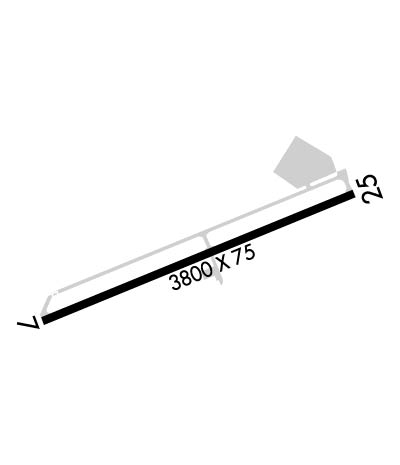
| Lat: N 4553.5 Long: W 08444.3 Elev: 624 Var: +06 Longest Runway: 3800 | ||
| CTAF: 122.7 | ||
| ||||||||||||||||||||||||||||||
| ||||||||||||||||||||||||||||||
| Rwy | Rwy | |||||||
| 3800x75 | 3800' | 3800x75 | 3800' | |||||
| Runway ID | Single Wheel | Double Wheel | Double Tandem Wheel | Dual Double Wheel |
| 07/25 | 24,000 | N/A | N/A | N/A |
| These numbers are Advisory and are not limits. The Airport Manager should have more accurate Weight Limits | ||||
 Airport Diagram might not be current. | |
| Facility Name: | MACKINAC COUNTY |
| City Name: | ST IGNACE |
| County: | MACKINAC |
| State abbrev: | MI |
| State Name: | MICHIGAN |
| Ownership: | PUBLICLY OWNED |
| Use: | OPEN TO THE PUBLIC |
| Owner's Name: | MACKINAC CO BOARD OF COMMISSIONERS |
| Address: | COURT HOUSE, 110 S MARLEY ST |
| SAINT IGNACE, MI 49781-1518 | |
| Owner's Phone: | 906-643-7300 |
| Manager's Name: | PAUL S FULLERTON |
| Address: | 1220 N STATE ST |
| SAINT IGNACE, MI 49781-1014 | |
| Phone: | 906-643-7327 |
| FAA Region: | GREAT LAKES |
| FAA Field Office: | DET |

| Date | Sunrise | Sunset |
|---|---|---|
| 06/08/26 Monday | 5:49 | 21:27 |
| 06/09/26 Tuesday | 5:49 | 21:28 |
| 06/10/26 Wednesday | 5:49 | 21:28 |
| 06/11/26 Thursday | 5:48 | 21:29 |
| 06/12/26 Friday | 5:48 | 21:30 |
| 06/13/26 Saturday | 5:48 | 21:30 |
| 06/14/26 Sunday | 5:48 | 21:31 |
| 06/15/26 Monday | 5:48 | 21:31 |
| 06/16/26 Tuesday | 5:48 | 21:31 |
| 06/17/26 Wednesday | 5:48 | 21:32 |
| 06/18/26 Thursday | 5:48 | 21:32 |
| 06/19/26 Friday | 5:48 | 21:32 |
| 06/20/26 Saturday | 5:48 | 21:33 |
| 06/21/26 Sunday | 5:48 | 21:33 |
| Airport Attendance Schedule | 7 Days A Week DAWN-DUSK; FOR SVC AFT HRS CALL AMGR RES AT 906-643-7161. |
| Airport Status | OPERATIONAL (This Status can change at any time - please check NOTAMS) |
| Airport Lighting Schedule | ACTVT REIL RWY 07 & 25; PAPI RWY 07 & 25; MIRL RWY 07/25; RAMP LGTS - CTAF. |
| Airport Storage Available | Tie Downs, Hanger |
| Extra Services Available | Charter |
| Wind Indicator | YES - (unlit) |
| Control Tower | NO |
| CTAF Frequency | 122.700 |
| Unicom Frequency | 122.700 |
| Rotating Beacon Color | WG |
| Segmented Circle | Y-L |
| Landing Fee | NO |
| Airport Inspected | STATE - performed by STATE AERONAUTICAL PERSONNEL |
| Inspection Date | 10/15/2025 |
| Type of Fuel Available | Grade 100LL, JET A |
| Airframe Repair Service | MAJOR |
| Power Plant Repair Service | MAJOR |
| Latitude | N4553.5 |
| Longitude | W08444.3 (ESTIMATED) |
| Arpt Elevation | 623ft (SURVEYED) |
| Magnetic Variation | 06W |
| 1 miles NNW | of ST IGNACE |
| Traffic Pattern Altitude | |
| Sectional Chart | LAKE HURON |
| Operations (Reported) | Yearly | Avg. Daily |
|---|---|---|
| General Aviation Transient | 0 | 0 |
| General Aviation Local | 0 | 0 |
| Air Taxi | 0 | 0 |
| Commerical | 0 | 0 |
| Commuter | 0 | 0 |
| Military | 0 | 0 |
| Aircraft based on Field | |
|---|---|
| General Aviation Singles | 0 |
| General Aviation Multi | 0 |
| Jet Aircraft | 0 |
| General Aviation Helicopters | 0 |
| Military Aircraft | 0 |
| Gliders | 0 |
| Ultralights | 0 |
| FSS on field | NO |
| FSS tie-in | GREEN BAY |
| FSS Phone | 1-800-WX-BRIEF |
| Who issues Notams | GRB |
| Notam D service at airport | YES |
| ARTCC Name | MINNEAPOLIS |
| Airport Certification | |
| Aircraft Rescue & Firefighting Index | None |
| Airport of Entry | No |
| Custom Landing Rights | No |
| Joint Civil/Military | No |
| Military Landing rights | YES |
| NATIONAL PLAN OF INTEGRATED AIRPORT SYSTEMS (NPIAS) |
| GRANT AGREEMENTS UNDER FAAP/ADAP/AIP |
| ASSURANCES PURSUANT TO TITLE VI, CIVIL RIGHTS ACT OF 1964 |
| DEER, BIRDS, & WILDLIFE ON & INVOF ARPT. |
| MCD AWOS FREQ CAN BE RCVD ON THE GND. |
| RADIO CALL "SAINT IGNACE." |
| FOR CD CTC MINNEAPOLIS ARTCC AT 651-463-5588. |
Airport Communications & Frequencies:
| |||||||||
| Runway: 07 | Runway: 25 | ||
| Mag heading: | 74° | Mag heading: | 254° |
| Rwy Slope: | -.37% Down | Rwy Slope: | .37% Up |
| Approach: | Approach: | ||
| Pattern: | Left Traffic | Pattern: | Left Traffic |
| Markings: | NONPRECISION INSTRUMENT | Markings: | NONPRECISION INSTRUMENT |
| Marking Condition: | GOOD | Marking Condition: | GOOD |
| Arresting Dev: | Arresting Dev: | ||
| Lat & Long: | N4553.4 W08444.7 | Lat. & Long.: | N4553.6 W08443.9 |
| Elev: | 622.4 ft. MSL | Elev: | 608.3 ft. MSL |
| TCH: | 31 ft. AGL | TCH: | 45 ft. AGL |
| Visual Glide Path: | 4.00 degrees | Visual Glide Path: | 3.04 degrees |
| Displaced Threshold: | No | Displaced Threshold: | No |
| Touchdown Zone: | YES | Touchdown Zone: | YES |
| Touchdown Elev.: | 623.5 feet | Touchdown Elev.: | 622.6 feet |
| Visual Glide Slope: | 4-Light PAPI on LEFT side of Runway | Visual Glide Slope: | 4-Light PAPI on LEFT side of Runway |
| RVR Equipment: | RVR Equipment: | ||
| RVV Equipment: | NO | RVV Equipment: | NO |
| Approach Lights: | Approach Lights: | ||
| REIL: | YES | REIL: | YES |
| Centerline Lights: | NO | Centerline Lights: | NO |
| Touchdown lights: | NO | Touchdown lights: | NO |
| Runway Category: | Runway with a Non-precision Approach | Runway Category: | Runway with a Non-precision Approach |
| Declared Distances: | Declared Distances: | ||
| Obstructions: | BRUSH | Obstructions: | |
| Marked: | NOT Marked/Lighted | Marked: | |
| Clearance slope: | 13:1 | Clearance slope: | 20:1 |
| Obstruction height: | 14 feet AGL | Obstruction height: | |
| Dist. from runway: | 387 feet | Dist. from runway: | |
| Centerline offset: | 209 right of centerline | Centerline offset: | |
| Comments: | 5-10 FT BRUSH, 150-199 FT DIST, 240 FT L. | Comments: |
Thanks for using FltPlan.com
all rights reserved © 1999-2026 by Flight Plan LLC


